Placitas, Sandoval County, New Mexico

Last updated

Placitas, New Mexico
CDP
Las Placitas Presbyterian Church, Placitas NM.jpg
Las Placitas Presbyterian Church
Sandoval County New Mexico Incorporated and Unincorporated areas Placitas Highlighted.svg
Location of Placitas, New Mexico
Usa edcp location map.svg
Red pog.svg
Placitas, New Mexico
Location in the United States
Coordinates: 35°19′3″N106°27′7″W / 35.31750°N 106.45194°W / 35.31750; -106.45194
Country United States
State New Mexico
County Sandoval
Area
[1]
  Total29.44 sq mi (76.25 km2)
  Land29.44 sq mi (76.25 km2)
  Water0.00 sq mi (0.00 km2)
Elevation
5,955 ft (1,815 m)
Population
 (2020) [2]
  Total5,041
  Density171.23/sq mi (66.11/km2)
Time zone UTC-7 (Mountain (MST))
  Summer (DST) UTC-6 (MDT)
ZIP code
87043
Area code 505
FIPS code 35-58070
GNIS feature ID0915877

Placitas is a census-designated place (CDP) in Sandoval County, New Mexico, United States. As of the 2010 census, its population was 4,977. [3] It is part of the Albuquerque Metropolitan Statistical Area.

Contents

History

In 1767, 21 families received a land grant from Spain. They founded the village of San Jose de las Huertas near present-day Placitas. [4] [5] Around the year 1768, nomadic Native Americans raided the village. [4] In the 1830s, Placitas, which at the time was known as Las Placitas, [5] was settled. [4] On February 24th, 1894, Las Placitas Presbyterian Church was founded. [6] [7]

During the 1960s and 1970s, there were many hippie settlements near Placitas. These settlements include Sun Farm, Lower Farm, Little Farm, Dome Valley, and Tawapa. [4] [8] The only one of these settlements that still exists today is Sun Farm. [4]

Geography

Placitas is located at 35°19′3″N106°27′7″W / 35.31750°N 106.45194°W / 35.31750; -106.45194 (35.317444, -106.452065). [9]

According to the United States Census Bureau, the CDP has a total area of 29.7 square miles (77 km2), all land.

Demographics

Historical population
CensusPop.Note
2020 5,041
U.S. Decennial Census [10] [2]

At the 2000 census there were 3,452 people, 1,485 households, and 1,101 families in the CDP. The population density was 115.4 inhabitants per square mile (44.6/km2). There were 1,606 housing units at an average density of 53.7 per square mile (20.7/km2). The racial makeup of the CDP was 83.52% White, 0.70% African American, 1.30% Native American, 0.52% Asian, 0.03% Pacific Islander, 10.46% from other races, and 3.48% from two or more races. Hispanic or Latino of any race were 20.22%. [11]

Of the 1,485 households 23.5% had children under the age of 18 living with them, 67.0% were married couples living together, 5.2% had a female householder with no husband present, and 25.8% were non-families. 20.1% of households were one person and 4.8% were one person aged 65 or older. The average household size was 2.32 and the average family size was 2.66.

The age distribution was 18.8% under the age of 18, 3.0% from 18 to 24, 25.1% from 25 to 44, 42.5% from 45 to 64, and 10.5% 65 or older. The median age was 46 years. For every 100 females, there were 92.8 males. For every 100 females age 18 and over, there were 93.8 males.

The median household income was $60,597 and the median family income was $71,696. Males had a median income of $46,667 versus $41,914 for females. The per capita income for the CDP was $36,243. About 2.6% of families and 7.0% of the population were below the poverty line, including 12.7% of those under age 18 and 3.8% of those age 65 or over.

Education

Placitas is in the Bernalillo Public Schools district, [12] which operates Placitas Elementary School, [13] Bernalillo Middle School (the zoned middle school of this community), [14] and Bernalillo High School.

Related Research Articles

<span class="mw-page-title-main">Sandoval County, New Mexico</span> County in New Mexico, United States

Sandoval County is located in the U.S. state of New Mexico. As of the 2020 census, the population was 148,834, making it the fourth-most populous county in New Mexico. The county seat is Bernalillo.

<span class="mw-page-title-main">Bernalillo County, New Mexico</span> County in New Mexico, United States

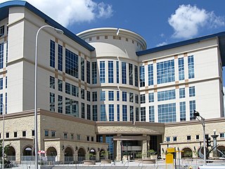
Bernalillo County is the most populous county in the U.S. state of New Mexico. As of the 2020 census, the population was 676,444. The county seat, Albuquerque, is the most populous city in New Mexico.

<span class="mw-page-title-main">Cedar Crest, New Mexico</span> Census-designated place in New Mexico, United States

Cedar Crest is a census-designated place (CDP) in Bernalillo County, New Mexico, United States. The population was 958 at the 2010 census. It is part of the Albuquerque Metropolitan Statistical Area.

<span class="mw-page-title-main">Chilili, New Mexico</span> Census-designated place in New Mexico, United States

Chilili is a census-designated place in Bernalillo County, New Mexico, United States. The population was 137 at the 2010 census. It is part of the Albuquerque Metropolitan Statistical Area.

<span class="mw-page-title-main">Isleta Village Proper, New Mexico</span> Census-designated place in New Mexico, United States

Isleta Village Proper is a census-designated place (CDP) in Bernalillo County, New Mexico, United States. The population was 491 at the 2010 census. It is part of the Albuquerque Metropolitan Statistical Area.

<span class="mw-page-title-main">South Valley, New Mexico</span> Census-designated place in New Mexico, United States

South Valley is a census-designated place (CDP) and unincorporated community in Bernalillo County, New Mexico, United States. The population was 38,338 at the 2020 Census. It is part of the Albuquerque Metropolitan Statistical Area. The U.S. Postal Service uses "Albuquerque" for all South Valley addresses.

<span class="mw-page-title-main">Chaparral, New Mexico</span> Census-designated place in New Mexico, United States

Chaparral is an unincorporated community and census-designated place (CDP) in Doña Ana and Otero counties, New Mexico. The population was 14,631 at the 2010 census. Chaparral is primarily a bedroom community for the neighboring city of El Paso, Texas, and the neighboring military installations of White Sands Missile Range and Fort Bliss. It is officially part of the Las Cruces Metropolitan Statistical Area.

<span class="mw-page-title-main">Vado, New Mexico</span> Place and community in the United States

Vado is an unincorporated community and census-designated place (CDP) in Doña Ana County, New Mexico, United States. The population was 3,194 at the 2010 census. The ZIP code for Vado is 88072, its area code is 575, and it is part of the Las Cruces Metropolitan Statistical Area.

<span class="mw-page-title-main">Algodones, New Mexico</span> CDP in New Mexico, United States

Algodones is a census-designated place (CDP) in Sandoval County, New Mexico, United States. The population was 814 at the 2010 census. It is part of the Albuquerque Metropolitan Statistical Area.

<span class="mw-page-title-main">Bernalillo, New Mexico</span> Town in New Mexico, United States

Bernalillo is a town in and the county seat of Sandoval County, New Mexico, United States. As of the 2020 census, the town population was 8,977.

<span class="mw-page-title-main">Cochiti, New Mexico</span> CDP in New Mexico, United States

Cochiti is a census-designated place (CDP) in Sandoval County, New Mexico, United States. A historic pueblo of the Cochiti people, one of the Keresan Nations, it is part of the Albuquerque Metropolitan Statistical Area. The population was 528 at the 2010 census. Located 22 miles (35 km) southwest of Santa Fe, the community is listed as a historic district on the National Register of Historic Places.

<span class="mw-page-title-main">Peña Blanca, New Mexico</span> CDP in New Mexico, United States

Peña Blanca is a census-designated place (CDP) in Sandoval County, New Mexico. As of the 2000 census, the CDP population was 661. It is part of the Albuquerque Metropolitan Statistical Area.

<span class="mw-page-title-main">Ponderosa, New Mexico</span> CDP in New Mexico, United States

Ponderosa is a census-designated place (CDP) in Sandoval County, New Mexico, United States. The population was 383 as of New Mexico's 2015 Census. It is part of the Albuquerque Metropolitan Statistical Area.

<span class="mw-page-title-main">Pueblo of Sandia Village, New Mexico</span> Village in Sandoval County, New Mexico, US

Pueblo of Sandia Village is a census-designated place (CDP) in Sandoval County, New Mexico, United States. The population was 344 at the 2000 census. It is part of the Albuquerque Metropolitan Statistical Area.

<span class="mw-page-title-main">San Felipe Pueblo, New Mexico</span> CDP in New Mexico, United States

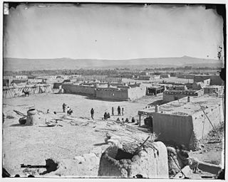
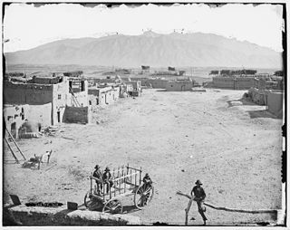
San Felipe Pueblo is a census-designated place (CDP) in Sandoval County, New Mexico, United States, and is located 10 miles (16 km) north of Bernalillo. As of the 2000 census, the CDP population was 2,080. It is part of the Albuquerque Metropolitan Statistical Area.

<span class="mw-page-title-main">Santa Ana Pueblo, New Mexico</span> CDP in New Mexico, United States

Santa Ana Pueblo is a census-designated place (CDP) in Sandoval County, New Mexico, United States. As of the 2000 census, the CDP had a total population of 479. It is part of the Albuquerque Metropolitan Statistical Area. The Pueblo, named Tamaya in Keres, administers a total reservation land of 73,000 acres (295 km2) in the Rio Grande valley and is composed of Native Americans who speak an eastern dialect of the Keresan languages.

<span class="mw-page-title-main">Agua Fria, New Mexico</span> CDP in New Mexico, United States

Agua Fria is a census-designated place (CDP) in Santa Fe County, New Mexico, United States. It is part of the Santa Fe, New Mexico Metropolitan Statistical Area. The population was 2,800 at the 2010 census. Agua Fria Village is a "Traditional Historic Community" (THC) as designated by the Santa Fe Board of County Commissioners in 1995 and subsequent Santa Fe County Ordinance #1996-16, as allowed by State Statute.

<span class="mw-page-title-main">Edgewood, New Mexico</span> Town in New Mexico, United States

Edgewood is a town in Santa Fe County, New Mexico, United States. Through annexations, its town boundaries now extend into Bernalillo and Sandoval counties. It is part of the Albuquerque–Santa Fe–Las Vegas combined statistical area.

<span class="mw-page-title-main">Corrales, New Mexico</span> Village in New Mexico, United States

Corrales is a village in southern Sandoval County, New Mexico, United States. First farmed by Tiquex Pueblo people, chosen due to its proximity to the Rio Grande, as documented by Hispano farmers of Nuevo México in the late 1500s. Despite being a part of the Albuquerque metropolitan area, the village maintains its rural character, while also being surrounded by the cities of Albuquerque and Rio Rancho. The population of Corrales was 8,329 at the 2010 Census.

<span class="mw-page-title-main">Albuquerque metropolitan area</span> Metropolitan area in central New Mexico

The Albuquerque Metropolitan Statistical Area, sometimes referred to as Tiguex, is a metropolitan area in central New Mexico centered on the city of Albuquerque. The metro comprises four counties: Bernalillo, Sandoval, Torrance, and Valencia. As of the 2010 United States Census, the MSA had a population of 887,077. The population is estimated to be 923,630 as of July 1, 2020, making Greater Albuquerque the 61st-largest MSA in the nation. The Albuquerque MSA forms a part of the larger Albuquerque–Santa Fe–Las Vegas combined statistical area with a 2020 estimated population of 1,165,181, ranked 49th-largest in the country.

References

  1. "ArcGIS REST Services Directory". United States Census Bureau. Retrieved October 12, 2022.
  2. 1 2 "Census Population API". United States Census Bureau. Retrieved October 12, 2022.
  3. "2010 Census Gazetteer Files - Places: New Mexico". U.S. Census Bureau. Archived from the original on July 14, 2014. Retrieved August 21, 2014.
  4. 1 2 3 4 5 Gajkowski, Bob; Montgomery, Lynn. "*MDWCA - Las Acequias de Placitas Water System". *MDWCA - Las Acequias de Placitas Water System. Retrieved May 6, 2024.
  5. 1 2 Forest, Suzanne (December 1, 1996). "A Trail of Tangled Titles: Mining, Land Speculation, and the Dismemberment of the San Antonio de las Huertas Land Grant". New Mexico Historical Review: 361.
  6. "Las Placitas Presbyterian Church".
  7. Forrest, Suzanne Sims (January 16, 2017). Century of Faith: One Hundred Years in the Life of Las Placitas Presbyterian Church. pp. xv. ISBN   9781540397676.{{cite book}}: CS1 maint: date and year (link)
  8. Kurota, Alexander (November 7, 2005). "A Class III Cultural Resources Inventory of 44 Acres in Placitas, Sandoval County, New Mexico". Office of Contract Archaeology University of New Mexico.
  9. "US Gazetteer files: 2010, 2000, and 1990". United States Census Bureau. February 12, 2011. Retrieved April 23, 2011.
  10. "Census of Population and Housing". Census.gov. Retrieved June 4, 2016.
  11. "U.S. Census website". United States Census Bureau . Retrieved January 31, 2008.
  12. "2020 CENSUS - SCHOOL DISTRICT REFERENCE MAP: Sandoval County, NM" (PDF). U.S. Census Bureau . Retrieved January 9, 2022.
  13. "About Placitas Elementary". Placitas Elementary School. Retrieved March 17, 2023.
  14. "About Bernalillo Middle School". Bernalillo Middle School. Retrieved March 16, 2023.


Wild Horses of Placitas, 2012. They are the source of some controversy. One argument is that they eat the wild grass faster than it can renew itself, especially during drought, which may lead to erosion problems. Traffic safety is also of concern, due to the free-roaming horses crossing rural roads and a state highway (NM 165). Photo courtesy of John Fowler, Placitas. Wild Horses of Placitas.jpg
Wild Horses of Placitas, 2012. They are the source of some controversy. One argument is that they eat the wild grass faster than it can renew itself, especially during drought, which may lead to erosion problems. Traffic safety is also of concern, due to the free-roaming horses crossing rural roads and a state highway (NM 165). Photo courtesy of John Fowler, Placitas.