Ponderosa, New Mexico

Last updated

Ponderosa, New Mexico
CDP
Sandoval County New Mexico Incorporated and Unincorporated areas Ponderosa Highlighted.svg
Location of Ponderosa, New Mexico
Usa edcp location map.svg
Red pog.svg
Ponderosa, New Mexico
Location in the United States
Coordinates: 35°40′6″N106°39′52″W / 35.66833°N 106.66444°W / 35.66833; -106.66444
Country United States
State New Mexico
County Sandoval
Area
[1]
  Total9.13 sq mi (23.64 km2)
  Land9.13 sq mi (23.64 km2)
  Water0.00 sq mi (0.00 km2)
Elevation
6,010 ft (1,832 m)
Population
 (2020) [2]
  Total379
  Density41.53/sq mi (16.03/km2)
Time zone UTC-7 (Mountain (MST))
  Summer (DST) UTC-6 (MDT)
ZIP code
87044
Area code 505
FIPS code 35-58980
GNIS feature ID2409087

Ponderosa is a census-designated place (CDP) in Sandoval County, New Mexico, United States. The population was 383 as of New Mexico's 2015 Census. [3] It is part of the Albuquerque Metropolitan Statistical Area.

Contents

Geography

Ponderosa is located at 35°40′6″N106°39′52″W / 35.66833°N 106.66444°W / 35.66833; -106.66444 (35.668305, -106.664462). [4]

According to the United States Census Bureau, the CDP has a total area of 7.3 square miles (19 km2), all land.

Demographics

Historical population
CensusPop.Note
2020 379
U.S. Decennial Census [5] [2]

As of the census [6] of 2015, there are 383 people, 171 households, and 96 families. The population density is 42.4 people per square mile (16.4/km2). There are 198 housing units. The racial makeup of the 2000 CDP was 29.68% White, 0.32% African American, 4.52% Native American, 0.32% Asian, 0.32% Pacific Islander, 59.68% from other races, and 5.16% from two or more races. Hispanic or Latino of any race were 64.52% of the population. The 2015 Diversity Index is 71.

In 2000, there were 112 households, out of which 42.0% had children under the age of 18 living with them, 70.5% were married couples living together, 5.4% had a female householder with no husband present, and 21.4% were non-families. 17.9% of all households were made up of individuals, and 5.4% had someone living alone who was 65 years of age or older. The average household size was 2.77 and the average family size was 3.16.

In the CDP, the population was spread out, with 28.1% under the age of 18, 7.1% from 18 to 24, 21.0% from 25 to 44, 35.2% from 45 to 64, and 8.7% who were 65 years of age or older. The median age was 41 years. For every 100 females, there were 109.5 males. For every 100 females age 18 and over, there were 100.9 males.

In 2015 the median income for a household is $60,156. In the 2000 CDP the median income for a family was $45,417. Males had a median income of $39,300 versus $28,182 for females. The per capita income for the CDP is $33,781. In 2000, about 14.5% of families and 19.8% of the population were below the poverty line, including 32.0% of those under age 18 and none of those age 65 or over.

Education

Most of Ponderosa is within the Jemez Valley Public Schools school district. A portion extends into Bernalillo Public Schools. [7]

Local attractions

Related Research Articles

<span class="mw-page-title-main">Sandoval County, New Mexico</span> County in New Mexico, United States

Sandoval County is located in the U.S. state of New Mexico. As of the 2020 census, the population was 148,834, making it the fourth-most populous county in New Mexico. The county seat is Bernalillo.

<span class="mw-page-title-main">South Valley, New Mexico</span> Census-designated place in New Mexico, United States

South Valley is a census-designated place (CDP) and town in Bernalillo County, New Mexico, United States. The population was 40,976 at the 2010 Census. It is part of the Albuquerque Metropolitan Statistical Area. The U.S. Postal Service uses "Albuquerque" for all South Valley addresses.

<span class="mw-page-title-main">San Juan, New Mexico</span> CDP in New Mexico, United States

San Juan is a census-designated place (CDP) in Rio Arriba County, New Mexico, United States. The population was 592 at the 2000 census.

<span class="mw-page-title-main">Algodones, New Mexico</span> CDP in New Mexico, United States

Algodones is a census-designated place (CDP) in Sandoval County, New Mexico, United States. The population was 814 at the 2010 census. It is part of the Albuquerque Metropolitan Statistical Area.

<span class="mw-page-title-main">La Jara, New Mexico</span> CDP in New Mexico, United States

La Jara is a census-designated place (CDP) in Sandoval County, New Mexico, United States. The population was 209 at the 2000 census. It is part of the Albuquerque Metropolitan Statistical Area.

<span class="mw-page-title-main">Peña Blanca, New Mexico</span> CDP in New Mexico, United States

Peña Blanca is a census-designated place (CDP) in Sandoval County, New Mexico. As of the 2000 census, the CDP population was 661. It is part of the Albuquerque Metropolitan Statistical Area.

<span class="mw-page-title-main">Placitas, Sandoval County, New Mexico</span> CDP in New Mexico, United States

Placitas is a census-designated place (CDP) in Sandoval County, New Mexico, United States. As of the 2010 census, its population was 4,977. It is part of the Albuquerque Metropolitan Statistical Area.

<span class="mw-page-title-main">Pueblo of Sandia Village, New Mexico</span> Village in Sandoval County, New Mexico, US

Pueblo of Sandia Village is a census-designated place (CDP) in Sandoval County, New Mexico, United States. The population was 344 at the 2000 census. It is part of the Albuquerque Metropolitan Statistical Area.

<span class="mw-page-title-main">Regina, New Mexico</span> CDP in New Mexico, United States

Regina is a census-designated place (CDP)) in Sandoval County, New Mexico, United States. The population was 99 at the 2000 census. It is part of the Albuquerque Metropolitan Statistical Area. It was named for Regina, Saskatchewan.

<span class="mw-page-title-main">San Felipe Pueblo, New Mexico</span> CDP in New Mexico, United States

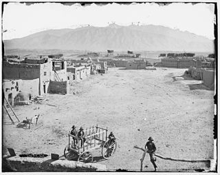
San Felipe Pueblo is a census-designated place (CDP) in Sandoval County, New Mexico, United States, and is located 10 miles (16 km) north of Bernalillo. As of the 2000 census, the CDP population was 2,080. It is part of the Albuquerque Metropolitan Statistical Area.

<span class="mw-page-title-main">Torreon, Sandoval County, New Mexico</span> Census-designate place in Sandoval County, New Mexico, United States

Torreon is a census-designated place (CDP) in Sandoval County, New Mexico, United States. The population was 297 at the 2000 census. It is part of the Albuquerque Metropolitan Statistical Area.

<span class="mw-page-title-main">Cuyamungue, New Mexico</span> Census-designated place in New Mexico, United States

Cuyamungue is a census-designated place (CDP) in Santa Fe County, New Mexico, United States. It is part of the Santa Fe, New Mexico Metropolitan Statistical Area. The population was 479 at the 2010 census.

<span class="mw-page-title-main">El Rancho, New Mexico</span> Census-designated place in New Mexico, United States

El Rancho is a census-designated place (CDP) in Santa Fe County, New Mexico, United States. It is part of the Santa Fe, New Mexico Metropolitan Statistical Area. The population was 1,199 at the 2010 census.

<span class="mw-page-title-main">El Valle de Arroyo Seco, New Mexico</span> CDP in New Mexico, United States

El Valle de Arroyo Seco is a census-designated place (CDP) in Santa Fe County, New Mexico, United States. It is part of the Santa Fe, New Mexico Metropolitan Statistical Area. The population was 1,440 at the 2010 census.

<span class="mw-page-title-main">Jaconita, New Mexico</span> Census-designated place in New Mexico, United States

Jaconita is a census-designated place (CDP) in Santa Fe County, New Mexico, United States. It is part of the Santa Fe, New Mexico Metropolitan Statistical Area. The population was 332 at the 2010 census. It is considered to be a part of the Pojoaque Valley.

<span class="mw-page-title-main">La Puebla, New Mexico</span> CDP in New Mexico, United States

La Puebla is a census-designated place (CDP) in Santa Fe County, New Mexico, United States. It is part of the Santa Fe, New Mexico Metropolitan Statistical Area. The population was 1,296 at the 2000 census.

<span class="mw-page-title-main">Pojoaque, New Mexico</span> CDP in New Mexico, United States

Pojoaque, Po’su wae geh, which translates to “water gathering place”, is a census-designated place (CDP) in Santa Fe County, New Mexico, United States. It is part of the Santa Fe, New Mexico Metropolitan Statistical Area. The population was 1,907 at the 2010 census. Pojoaque Pueblo, a neighboring community, is an Indian reservation, and the town of Pojoaque is a collection of communities near the pueblo with people from various ethnic backgrounds. The area of Pojoaque includes the neighborhoods of Cuyamungue, Jacona, Jaconita, Nambé and El Rancho.

<span class="mw-page-title-main">Sombrillo, New Mexico</span> Census-designated place in Santa Fe County, New Mexico, United States

Sombrillo is a census-designated place (CDP) in Santa Fe County, New Mexico, United States. It is part of the Santa Fe, New Mexico Metropolitan Statistical Area. The population was 493 according to the 2000 census.

<span class="mw-page-title-main">Peralta, New Mexico</span> Town in New Mexico, United States

Peralta is a town in Valencia County, New Mexico, United States. Prior to its incorporation on July 1, 2007, it was a census-designated place (CDP). The population was 3,660 as of the 2010 census. Peralta is part of the Albuquerque metropolitan area.

<span class="mw-page-title-main">Jemez Pueblo, New Mexico</span> CDP in New Mexico, United States

Jemez Pueblo is a census-designated place (CDP) in Sandoval County, New Mexico, United States. The population was 1,788 at the 2010 census. It is part of the Albuquerque Metropolitan Statistical Area.

References

  1. "ArcGIS REST Services Directory". United States Census Bureau. Retrieved October 12, 2022.
  2. 1 2 "Census Population API". United States Census Bureau. Retrieved October 12, 2022.
  3. "Ponderosa, NM Profile: Facts, Map & Data". newmexico.hometownlocator.com. Retrieved May 31, 2016.
  4. "US Gazetteer files: 2010, 2000, and 1990". United States Census Bureau. February 12, 2011. Retrieved April 23, 2011.
  5. "Census of Population and Housing". Census.gov. Retrieved June 4, 2016.
  6. "U.S. Census website". United States Census Bureau . Retrieved January 31, 2008.
  7. "2020 CENSUS - SCHOOL DISTRICT REFERENCE MAP: Sandoval County, NM" (PDF). U.S. Census Bureau . Retrieved July 12, 2022.