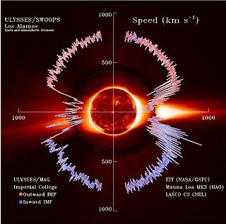
The solar wind is a stream of charged particles released from the upper atmosphere of the Sun, called the corona. This plasma mostly consists of electrons, protons and alpha particles with kinetic energy between 0.5 and 10 keV. The composition of the solar wind plasma also includes a mixture of materials found in the solar plasma: trace amounts of heavy ions and atomic nuclei of elements such as C, N, O, Ne, Mg, Si, S, and Fe. There are also rarer traces of some other nuclei and isotopes such as P, Ti, Cr, 54Fe and 56Fe, and 58Ni, 60Ni, and 62Ni. Superimposed with the solar-wind plasma is the interplanetary magnetic field. The solar wind varies in density, temperature and speed over time and over solar latitude and longitude. Its particles can escape the Sun's gravity because of their high energy resulting from the high temperature of the corona, which in turn is a result of the coronal magnetic field. The boundary separating the corona from the solar wind is called the Alfvén surface.

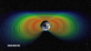
A Van Allen radiation belt is a zone of energetic charged particles, most of which originate from the solar wind, that are captured by and held around a planet by that planet's magnetosphere. Earth has two such belts, and sometimes others may be temporarily created. The belts are named after James Van Allen, who is credited with their discovery. Earth's two main belts extend from an altitude of about 640 to 58,000 km above the surface, in which region radiation levels vary. Most of the particles that form the belts are thought to come from solar wind and other particles by cosmic rays. By trapping the solar wind, the magnetic field deflects those energetic particles and protects the atmosphere from destruction.

Nozomi was a Mars orbiter that failed to reach Mars due to electrical failures. The mission was terminated on December 31, 2003.

Mars 96 was a failed Mars mission launched in 1996 to investigate Mars by the Russian Space Forces and not directly related to the Soviet Mars probe program of the same name. After failure of the second fourth-stage burn, the probe assembly re-entered the Earth's atmosphere, breaking up over a 320 km (200 mi) long portion of the Pacific Ocean, Chile, and Bolivia. The Mars 96 spacecraft was based on the Phobos probes launched to Mars in 1988. They were of a new design at the time and both ultimately failed. For the Mars 96 mission the designers believed they had corrected the flaws of the Phobos probes, but the value of their improvements was never demonstrated due to the destruction of the probe during the launch phase.

IMAGE is a NASA Medium Explorer mission that studied the global response of the Earth's magnetosphere to changes in the solar wind. It was believed lost but as of August 2018 might be recoverable. It was launched 25 March 2000, at 20:34:43.929 UTC, by a Delta II launch vehicle from Vandenberg Air Force Base on a two-year mission. Almost six years later, it unexpectedly ceased operations in December 2005 during its extended mission and was declared lost. The spacecraft was part of NASA's Sun-Earth Connections Program, and its data has been used in over 400 research articles published in peer-reviewed journals. It had special cameras that provided various breakthroughs in understanding the dynamics of plasma around the Earth. The principal investigator was Jim Burch of the Southwest Research Institute.

Ørsted is an Earth science satellite launched in 1999 to study the earth's geomagnetic field. It is Denmark's first satellite, named after Hans Christian Ørsted (1777–1851), a Danish physicist and professor at the University of Copenhagen, who discovered electromagnetism in 1820.

Explorer 52, also known as Hawkeye-1, Injun-F, Neutral Point Explorer, IE-D, Ionospheric Explorer-D, was a NASA satellite launched on 3 June 1974, from Vandenberg Air Force Base on a Scout E-1 launch vehicle.

Geotail was a satellite that observed the Earth's magnetosphere. It was developed by Japan's ISAS in association with the United States' NASA, and was launched by a Delta II rocket on 24 July 1992 from Cape Canaveral Air Force Station.

Canadian Geospace Monitoring (CGSM) is a Canadian space science program that was initiated in 2005. CGSM is funded primarily by the Canadian Space Agency, and consists of networks of imagers, meridian scanning photometers, riometers, magnetometers, digital ionosondes, and High Frequency SuperDARN radars. The overarching objective of CGSM is to provide synoptic observations of the spatio-temporal evolution of the ionospheric thermodynamics and electrodynamics at auroral and polar latitudes over a large region of Canada.
Dynamics Explorer was a NASA mission, launched on 3 August 1981, and terminated on 28 February 1991. It consisted of two unmanned satellites, DE-1 and DE-2, whose purpose was to investigate the interactions between plasmas in the magnetosphere and those in the ionosphere. The two satellites were launched together into polar coplanar orbits, which allowed them to simultaneously observe the upper and lower parts of the atmosphere.

The Magnetospheric Multiscale (MMS) Mission is a NASA robotic space mission to study the Earth's magnetosphere, using four identical spacecraft flying in a tetrahedral formation. The spacecraft were launched on 13 March 2015 at 02:44 UTC. The mission is designed to gather information about the microphysics of magnetic reconnection, energetic particle acceleration, and turbulence — processes that occur in many astrophysical plasmas. As of March 2020, the MMS spacecraft have enough fuel to remain operational until 2040.

Energetic Neutral Atom (ENA) imaging, often described as "seeing with atoms", is a technology used to create global images of otherwise invisible phenomena in the magnetospheres of planets and throughout the heliosphere.

An X-ray astronomy satellite studies X-ray emissions from celestial objects, as part of a branch of space science known as X-ray astronomy. Satellites are needed because X-radiation is absorbed by the Earth's atmosphere, so instruments to detect X-rays must be taken to high altitude by balloons, sounding rockets, and satellites.
Global Geospace science program (GGS) is designed to improve greatly the understanding the flow of energy, mass and momentum in the solar-terrestrial environment with particular emphasis on geospace. GGS has primary scientific objective of its own:

The ISEE-1 was an Explorer-class mother spacecraft, International Sun-Earth Explorer-1, was part of the mother/daughter/heliocentric mission. ISEE-1 was a 340.2 kg (750 lb) space probe used to study magnetic fields near the Earth. ISEE-1 was a spin-stabilized spacecraft and based on the design of the prior IMP series of spacecraft. ISEE-1 and ISEE-2 were launched on 22 October 1977, and they re-entered on 26 September 1987.

The ISEE-2 was an Explorer-class daughter spacecraft, International Sun-Earth Explorer-2, was part of the mother/daughter/heliocentric mission. ISEE-2 was a 165.78 kg (365.5 lb) space probe used to study magnetic fields near the Earth. ISEE-2 was a spin-stabilized spacecraft and based on the design of the prior IMP series of spacecraft. ISEE-1 and ISEE-2 were launched on 22 October 1977, and they re-entered on 26 September 1987.

Magnetometer (MAG) is an instrument suite on the Juno orbiter for planet Jupiter. The MAG instrument includes both the Fluxgate Magnetometer (FGM) and Advanced Stellar Compass (ASC) instruments. There two sets of MAG instrument suites, and they are both positioned on the far end of three solar panel array booms. Each MAG instrument suite observes the same swath of Jupiter, and by having two sets of instruments, determining what signal is from the planet and what is from spacecraft is supported. Avoiding signals from the spacecraft is another reason MAG is placed at the end of the solar panel boom, about 10 m and 12 m away from the central body of the Juno spacecraft.

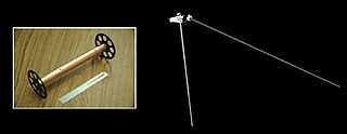
Waves is an experiment on the Juno spacecraft to study radio and plasma waves. It is part of collection of various types of instruments and experiments on the spacecraft; Waves is oriented towards understanding fields and particles in Jupiter's magnetosphere. Waves is on board the uncrewed Juno spacecraft, which was launched in 2011 and arrived at Jupiter in the summer of 2016. The major focus of study for Waves is Jupiter's magnetosphere, which if could be seen from Earth would be about twice the size of a full moon. It has a tear drop shape, and that tail extends away from the Sun by at least 5 AU. The Waves instrument is designed to help understand the interaction between Jupiter's atmosphere, its magnetic field, its magnetosphere, and to understand Jupiter's auroras. It is designed to detect radio frequencies from 50 Hz up to 40,000,000 Hz (40 MHz), and magnetic fields from 50 Hz to 20,000 Hz (20 kHz). It has two main sensors a dipole antenna and a magnetic search coil. The dipole antenna has two whip antenna's that extend 2.8 meters and they are attached to the main body of the spacecraft. This sensor has been compared to a rabbit ears set-top TV antenna. The search coil is overall a mu metal rod 15 cm (6 in) length with a fine copper wire wound 10,000 times around it. There are also two frequency receivers that each cover certain bands. Data handling is done by two radiation hardened systems on a chip. The data handling units are located inside the Juno Radiation Vault. Waves was allocated 410 Mbits of data per science orbit.

Dynamics Explorer 1 was a NASA high-altitude mission, launched on 3 August 1981, and terminated on 28 February 1991. It consisted of two satellites, DE-1 and DE-2, whose purpose was to investigate the interactions between plasmas in the magnetosphere and those in the ionosphere. The two satellites were launched together into polar coplanar orbits, which allowed them to simultaneously observe the upper and lower parts of the atmosphere.

Dynamics Explorer 2 was a NASA low-altitude mission, launched on 3 August 1981. It consisted of two satellites, DE-1 and DE-2, whose purpose was to investigate the interactions between plasmas in the magnetosphere and those in the ionosphere. The two satellites were launched together into polar coplanar orbits, which allowed them to simultaneously observe the upper and lower parts of the atmosphere.


