
The ionosphere is the ionized part of the upper atmosphere of Earth, from about 48 km (30 mi) to 965 km (600 mi) above sea level, a region that includes the thermosphere and parts of the mesosphere and exosphere. The ionosphere is ionized by solar radiation. It plays an important role in atmospheric electricity and forms the inner edge of the magnetosphere. It has practical importance because, among other functions, it influences radio propagation to distant places on Earth. It also affects GPS signals that travel through this layer.

Microwave is a form of electromagnetic radiation with wavelengths shorter than other radio waves but longer than infrared waves. Its wavelength ranges from about one meter to one millimeter, corresponding to frequencies between 300 MHz and 300 GHz, broadly construed. A more common definition in radio-frequency engineering is the range between 1 and 100 GHz, or between 1 and 3000 GHz . The prefix micro- in microwave is not meant to suggest a wavelength in the micrometer range; rather, it indicates that microwaves are small, compared to the radio waves used in prior radio technology.
Radar is a system that uses radio waves to determine the distance (ranging), direction, and radial velocity of objects relative to the site. It is a radiodetermination method used to detect and track aircraft, ships, spacecraft, guided missiles, motor vehicles, map weather formations, and terrain.

In antenna theory, a phased array usually means an electronically scanned array, a computer-controlled array of antennas which creates a beam of radio waves that can be electronically steered to point in different directions without moving the antennas. The general theory of an electromagnetic phased array also finds applications in ultrasonic and medical imaging application and in optics optical phased array.

The High-frequency Active Auroral Research Program (HAARP) is a University of Alaska Fairbanks program which researches the ionosphere – the highest, ionized part of Earth's atmosphere.

High frequency (HF) is the ITU designation for the band of radio waves with frequency between 3 and 30 megahertz (MHz). It is also known as the decameter band or decameter wave as its wavelengths range from one to ten decameters. Frequencies immediately below HF are denoted medium frequency (MF), while the next band of higher frequencies is known as the very high frequency (VHF) band. The HF band is a major part of the shortwave band of frequencies, so communication at these frequencies is often called shortwave radio. Because radio waves in this band can be reflected back to Earth by the ionosphere layer in the atmosphere – a method known as "skip" or "skywave" propagation – these frequencies are suitable for long-distance communication across intercontinental distances and for mountainous terrains which prevent line-of-sight communications. The band is used by international shortwave broadcasting stations (3.95–25.82 MHz), aviation communication, government time stations, weather stations, amateur radio and citizens band services, among other uses.
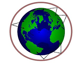
In radio communication, skywave or skip refers to the propagation of radio waves reflected or refracted back toward Earth from the ionosphere, an electrically charged layer of the upper atmosphere. Since it is not limited by the curvature of the Earth, skywave propagation can be used to communicate beyond the horizon, at intercontinental distances. It is mostly used in the shortwave frequency bands.

Beamforming or spatial filtering is a signal processing technique used in sensor arrays for directional signal transmission or reception. This is achieved by combining elements in an antenna array in such a way that signals at particular angles experience constructive interference while others experience destructive interference. Beamforming can be used at both the transmitting and receiving ends in order to achieve spatial selectivity. The improvement compared with omnidirectional reception/transmission is known as the directivity of the array.

Over-the-horizon radar (OTH), sometimes called beyond the horizon radar (BTH), is a type of radar system with the ability to detect targets at very long ranges, typically hundreds to thousands of kilometres, beyond the radar horizon, which is the distance limit for ordinary radar. Several OTH radar systems were deployed starting in the 1950s and 1960s as part of early-warning radar systems, but airborne early warning systems have generally replaced these. OTH radars have recently been making a comeback, as the need for accurate long-range tracking has become less important since the ending of the Cold War, and less-expensive ground-based radars are once again being considered for roles such as maritime reconnaissance and drug enforcement.

The Jindalee Operational Radar Network (JORN) is an over-the-horizon radar (OHR) network operated by the Royal Australian Air Force (RAAF) that can monitor air and sea movements across 37,000 square kilometres (14,000 sq mi). It has a normal operating range of 1,000–3,000 kilometres (620–1,860 mi). The network is used in the defence of Australia, and can also monitor maritime operations, wave heights and wind directions.
EISCAT operates three incoherent scatter radar systems in Northern Scandinavia and Svalbard. The facilities are used to study the interaction between the Sun and the Earth as revealed by disturbances in the ionosphere and magnetosphere.
Non-line-of-sight (NLOS) radio propagation occurs outside of the typical line-of-sight (LOS) between the transmitter and receiver, such as in ground reflections. Near-line-of-sight conditions refer to partial obstruction by a physical object present in the innermost Fresnel zone.

The Super Dual Auroral Radar Network (SuperDARN) is an international scientific radar network consisting of 35 high frequency (HF) radars located in both the Northern and Southern Hemispheres. SuperDARN radars are primarily used to map high-latitude plasma convection in the F region of the ionosphere, but the radars are also used to study a wider range of geospace phenomena including field aligned currents, magnetic reconnection, geomagnetic storms and substorms, magnetospheric MHD waves, mesospheric winds via meteor ionization trails, and interhemispheric plasma convection asymmetries. The SuperDARN collaboration is composed of radars operated by JHU/APL, Virginia Tech, Dartmouth College, the Geophysical Institute at the University of Alaska Fairbanks, the Institute of Space and Atmospheric Studies at the University of Saskatchewan, the University of Leicester, Lancaster University, La Trobe University, the Solar-Terrestrial Environment Laboratory at Nagoya University, the British Antarctic Survey and the Institute for Space Astrophysics and Planetology.

The Southern Hemisphere Auroral Radar Experiment, or SHARE, started in 1988, is an Antarctic research project designed to observe velocities and irregularities of electrical fields in the ionosphere and magnetosphere. It is operated jointly by the University of Natal, Potchefstroom University, the British Antarctic Survey and Johns Hopkins University and operates out of British Halley Station, South African SANAE IV Station and Japanese Showa Station.

Sodar, an acronym of sonic detection and ranging, is a meteorological instrument used as a wind profiler based on the scattering of sound waves by atmospheric turbulence. Sodar equipment is used to measure wind speed at various heights above the ground, and the thermodynamic structure of the lower layer of the atmosphere.
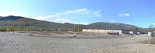
An ionospheric heater, or an ionospheric HF pump facility, is a powerful radio wave transmitter with an array of antennas which is used for research of plasma turbulence, the ionosphere and upper atmosphere.
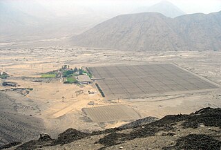
The Jicamarca Radio Observatory (JRO) is the equatorial anchor of the Western Hemisphere chain of Incoherent Scatter Radar (ISR) observatories extending from Lima, Peru to Søndre Strømfjord, Greenland. JRO is the premier scientific facility in the world for studying the equatorial ionosphere. The observatory is about half an hour drive inland (east) from Lima and 10 km from the Central Highway. The magnetic dip angle is about 1°, and varies slightly with altitude and year. The radar can accurately determine the direction of the Earth's magnetic field (B) and can be pointed perpendicular to B at altitudes throughout the ionosphere. The study of the equatorial ionosphere is rapidly becoming a mature field due, in large part, to the contributions made by JRO in radio science.

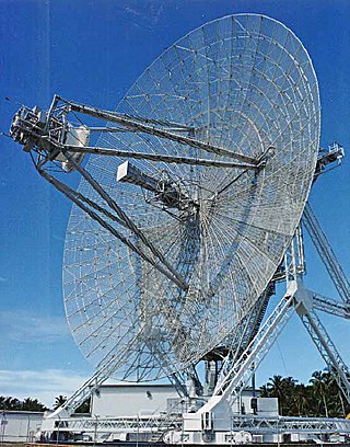
The Millstone Hill Steerable Antenna, or MISA, is a fully steerable dish antenna, 46 metres (151 ft) in diameter, designed by the Stanford Research Institute (SRI) in 1959. It is currently located at MIT Haystack Observatory in Westford, Massachusetts.
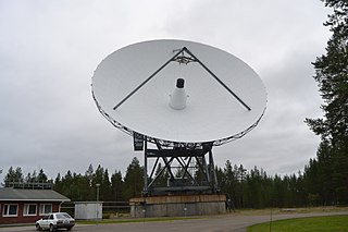
The Kilpisjärvi Atmospheric Imaging Receiver Array (KAIRA) is an astronomical observatory operated by the Sodankylä Geophysical Observatory on behalf of Oulu University. It is located at Kilpisjärvi, Enontekiö near the border with Norway. It comprises two LOFAR-derived radio telescope systems and is capable of observing at HF and VHF radio frequencies. It is used for atmospheric, near-Earth space and astronomical research. KAIRA uses LOFAR phased-array antennas and digital signal-processing hardware. The phased array configuration has no moving parts and with digital control, allows KAIRA to quickly scan the sky, giving KAIRA a large field of view. KAIRA can produce a continuous all-sky image of the radio transparency of ionosphere, using cosmic radio noise for "illumination" (riometry). KAIRA can also obtain electron density profiles in the atmosphere. This allows the study of the interaction of the solar wind with the atmosphere, such as in aurora borealis and other space weather phenomena. In addition to near-space imaging, the use of KAIRA has been demonstrated for long-baseline interferometry observations of pulsars.

Dynamics Explorer 1 was a NASA high-altitude mission, launched on 3 August 1981, and terminated on 28 February 1991. It consisted of two satellites, DE-1 and DE-2, whose purpose was to investigate the interactions between plasmas in the magnetosphere and those in the ionosphere. The two satellites were launched together into polar coplanar orbits, which allowed them to simultaneously observe the upper and lower parts of the atmosphere.
