Primary schools in Watford

Last updated

Map all coordinates using: OpenStreetMap

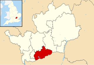
This article provides brief details of primary schools in the borough of Watford in Hertfordshire, England, United Kingdom. Some Watford children attend schools in the neighbouring boroughs of Three Rivers and Hertsmere.

Contents

All of the state-funded primary schools in Watford are co-educational. There are two Roman Catholic schools in the borough, both of which are voluntary aided schools. The remaining schools are all non-faith community schools. The Local Education Authority is Hertfordshire County Council. [1]

There are still some linked pairs of infant schools and junior schools, with the infant school covering Reception and Key Stage 1 (Years 1 and 2) and the junior school covering Key Stage 2 (Years 3 to 6). However most have been amalgamated in a single Junior Mixed Infant (JMI) school or (equivalently) primary school.

Central Watford, West Watford and Oxhey

Name Faith TypeOpenedIntake DCSF number Ofsted numberWeb Coordinates
BrometPrimary40 2385 117308 W 51°38′30″N0°23′18″W / 51.6417°N 0.3882°W / 51.6417; -0.3882 (Bromet Primary School)
Bushey and OxheyInfant188160 2117 117157 W 51°38′51″N0°22′48″W / 51.6474°N 0.3800°W / 51.6474; -0.3800 (Bushey and Oxhey Infant School)
CentralPrimary195030 2116 117156 W 51°39′21″N0°23′31″W / 51.6558°N 0.3920°W / 51.6558; -0.3920 (Central Primary School)
ChaterInfants190960 2122 117159 W 51°39′14″N0°24′31″W / 51.6538°N 0.4086°W / 51.6538; -0.4086 (Chater Infants School)
Junior 2120 117158 W 51°39′14″N0°24′11″W / 51.6538°N 0.4030°W / 51.6538; -0.4030 (Chater Junior School)
FieldInfants189160 2124 117161 W 51°39′03″N0°23′35″W / 51.6509°N 0.3931°W / 51.6509; -0.3931 (Field Infants School)
Junior 2123 117160 W 51°38′58″N0°23′37″W / 51.6495°N 0.3936°W / 51.6495; -0.3936 (Field Junior School)
HolywellPrimary60 2349 117290 W 51°38′39″N0°25′05″W / 51.6441°N 0.4181°W / 51.6441; -0.4181 (Holywell Primary School)
Laurance HainesPrimary197260 2398 117320 W 51°38′49″N0°24′27″W / 51.6470°N 0.4075°W / 51.6470; -0.4075 (Laurance Haines Primary School)
St Anthony's RC Primary197430 2428 117495 W 51°38′52″N0°25′12″W / 51.6477°N 0.4201°W / 51.6477; -0.4201 (St Anthony's Roman Catholic Primary School)
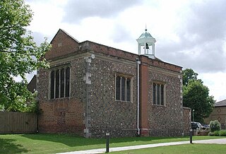
Watford Free School building Watford Free School.jpg
Watford Free School building

In the mid-19th century, the only schools in Watford were Mrs Fuller's Free School (established in 1704), by now in a poor state, and St Mary's National Schools (separate schools for boys and girls, founded in 1841). They were joined in 1859 by British schools, initially in Red Lion Yard and later moving to Sotheron Road (girls) and Beechen Grove (boys). Another set of National schools, attached to St Andrew's Church, were founded in 1860. [2] The Free School closed in 1882, and its endowment contributed to founding the Watford Endowed Schools, which provided secondary education and charged fees. [3] St Mary's National Schools closed in 1922, and the site is now occupied by the multi-storey Church car park. [4]

The Watford school board was established in 1883, and was chaired by Edward Mitchell Chater throughout its existence. The British schools and St Andrew's national schools became board schools the following year. The first new schools built by the board were the Watford Fields Schools, now known as the Field Schools. [2] The infants school moved to its present site in 1981. [5] The British boys' school closed in 1897, with the opening of Fearnly Street School, renamed Victoria School in 1903. The St Andrew's national schools continued until 1922. [6]

Following the Education Act 1902, the school board was abolished in 1903, and control of the schools passed to the Hertfordshire County Council. [2] The original Chater Schools, named after Edward Chater, consisted of two separate buildings on the site now occupied by the infants school, with juniors entering from Southsea Avenue, and infants from Harwoods Road. [7] The schools were rebuilt in 1988, with the junior school moving to the site of the former Victoria School. [7] [8]

Bushey and Oxhey Infant School was founded as Oxhey Village School, taking the name Oxhey Infants when it was rebuilt and enlarged in the 1960s. More recently it has been renamed Bushey and Oxhey Infants School It is linked with Bushey Manor Junior School (see Primary schools in Hertsmere). [9]

Central Primary School Central Primary School, Watford.jpg
Central Primary School

Central Primary School occupies a Grade II listed building built in 1884 to house the Watford Grammar School for Boys, which moved to West Watford in 1912. Watford Grammar School for Girls resided in the smaller building next door in the same period. The buildings then housed the Watford Central School until its move to Bushey in 1950 to become Bushey Grammar School, one of the predecessors of Queens' School. (The legend "Higher Elementary Schools", in terracotta tiles on the front of the building, replaced the earlier "Watford Endowed Schools" at the time of the Central School.) [10]

The school badge is based on that of the Watford Central School, which featured a crosslet fitchy and a scallop, details from the arms of Capell (Earl of Essex) and Villiers (Earl of Clarendon) respectively, though the crosslet has since been altered to a sword. [11] [12]

A proposal to open a one-form entry Muslim school in Tolpits Lane, West Watford has been approved by Hertfordshire County Council and passed to the Department for Children, Schools and Families for a final decision. [13]


North Watford and Garston

Name Faith TypeOpenedIntake DCSF number Ofsted numberWeb Coordinates
Alban WoodPrimary30 3981 134685 W 51°41′50″N0°24′01″W / 51.6972°N 0.4003°W / 51.6972; -0.4003 (Alban Wood Primary School)
BeechfieldPrimary30 2020 117094 W 51°40′33″N0°24′27″W / 51.6759°N 0.4076°W / 51.6759; -0.4076 (Beechfield Primary School)
BerrygrovePrimary200590 3980 134684 W 51°41′00″N0°23′07″W / 51.6834°N 0.3854°W / 51.6834; -0.3854 (Berrygrove Primary School)
CassioburyInfants196860 2354 117293 W 51°40′01″N0°25′19″W / 51.6670°N 0.4220°W / 51.6670; -0.4220 (Cassiobury Infant and Nursery School)
Junior 2132 117167 W 51°40′06″N0°25′21″W / 51.6684°N 0.4225°W / 51.6684; -0.4225 (Cassiobury Junior School)
Cherry TreePrimary30 2432 117339 W 51°40′53″N0°24′14″W / 51.6815°N 0.4040°W / 51.6815; -0.4040 (Cherry Tree Primary School)
Coates WayJMI197230 2433 117340 W 51°41′40″N0°22′45″W / 51.6945°N 0.3793°W / 51.6945; -0.3793 (Coates Way JMI School)
Holy Rood RC Primary188560 3985 127416 W 51°40′53″N0°25′33″W / 51.6814°N 0.4258°W / 51.6814; -0.4258 (Holy Rood Catholic Primary School)
KingswayInfants193860 2395 117317 W 51°41′19″N0°24′27″W / 51.6887°N 0.4076°W / 51.6887; -0.4076 (Kingsway Infant School)
Junior 2133 117168 W 51°41′20″N0°24′22″W / 51.6888°N 0.4060°W / 51.6888; -0.4060 (Kingsway Junior School)
KnutsfordPrimary193960 2130 117165 W 51°40′15″N0°23′13″W / 51.6708°N 0.3870°W / 51.6708; -0.3870 (Knutsford Primary School)
Leavesden GreenJMI30 2407 117324 W 51°41′32″N0°24′31″W / 51.6921°N 0.4085°W / 51.6921; -0.4085 (Leavesden Green JMI School)
Nascot WoodInfants197160 2991 117374 W 51°40′14″N0°24′33″W / 51.6705°N 0.4092°W / 51.6705; -0.4092 (Nascot Wood Infant and Nursery School)
Junior 2389 117311 W 51°40′13″N0°24′38″W / 51.6703°N 0.4106°W / 51.6703; -0.4106 (Nascot Wood Junior School)
OrchardPrimary195830 2115 117155 W 51°40′50″N0°24′48″W / 51.6805°N 0.4132°W / 51.6805; -0.4132 (Orchard Primary School)
ParkgateInfants190760 2126 117163 W 51°40′42″N0°23′30″W / 51.6783°N 0.3917°W / 51.6783; -0.3917 (Parkgate Infants and Nursery School)
Junior 2125 117162 W 51°40′30″N0°23′37″W / 51.6750°N 0.3936°W / 51.6750; -0.3936 (Parkgate Junior School)
Former Callowland School building Former Callowland School, Watford.jpg
Former Callowland School building

The Watford school board also built two schools (both since closed) in North Watford: a Callowland Boys' School (1892, 51°40′08″N0°23′57″W / 51.6689°N 0.3991°W / 51.6689; -0.3991 (Callowland School (closed)) ) and Alexandra Mixed School (1901, 51°40′22″N0°24′01″W / 51.6727°N 0.4002°W / 51.6727; -0.4002 (Alexandra School (closed)) ). [2] [14] The higher elementary department of Alexandra School later became a secondary modern school in Bushey, the other predecessor of Queens' School. [15]

Berrygrove Primary School replaced Meriden Primary, Garston Infants and Lea Farm Junior (formerly Garston Junior) Schools.

The Cassiobury schools lie within the affluent Cassiobury estate, and are heavily oversubscribed, with 4 applicants per place. [16] The junior school has the highest Key Stage 2 results in Watford, and half of the pupils typically go on to Watford Grammar School for Boys and Watford Grammar School for Girls. [17] The schools' badge features an earl's coronet over the arms of the Capell family (Earls of Essex), owners of the original Cassiobury, which included the site of the modern estate. [11]

Holy Rood Catholic Primary School is the oldest Roman Catholic school in Watford, started by the Dominican sisters as St Vincent's, a board school in Beechen Grove. In 1893 the school moved to a new building (now Grade II listed) adjacent to Holy Rood church in central Watford, taking its new name from the church in 1896. [14] [18] It taught pupils up to the age of 14 until the opening of St. Michael's Catholic High School in 1955, when it became a primary school. After many decades of overcrowding, the school moved to its present site in 1969. [19]

Knutsford Primary School lost its original school building in a fire in November 1999. After three years in temporary accommodation in the school fields, the school moved into a new building on the original site in 2002. [20] The school is oversubscribed, with 3.5 applicants per place. [16]

The Nascot Wood schools, within the affluent Nascot Wood area, are the most oversubscribed in Watford, with nearly 5 applicants for each place. [16] The area was formerly part of the Cassiobury Park estate of the Earls of Essex. The school badge, an earl's coronet over a monogram "SX", was the mark of the 5th Earl, George Capell-Coningsby (1757–1839). [21]

Parkgate Junior School was originally a boys' school, becoming mixed in August 1921. [22]

Related Research Articles

<span class="mw-page-title-main">Earl of Essex</span> Title in the Peerage of England

Earl of Essex is a title in the Peerage of England which was first created in the 12th century by King Stephen of England. The title has been recreated eight times from its original inception, beginning with a new first Earl upon each new creation. Possibly the most well-known Earls of Essex were Thomas Cromwell, chief minister to King Henry VIII, and Robert Devereux, 2nd Earl of Essex (1565–1601), a favourite of Queen Elizabeth I who led the Earl of Essex Rebellion in 1601.

<span class="mw-page-title-main">Watford</span> Town and borough in Hertfordshire, England

Watford is a town and borough in Hertfordshire, England, 15 mi (24 km) north-west of Central London, on the banks of the River Colne.

<span class="mw-page-title-main">Hertsmere</span> Place in England

Hertsmere is a local government district with borough status in Hertfordshire, England. Its council is based in Borehamwood. Other settlements in the borough include Bushey, Elstree, Radlett and Potters Bar. The borough contains several film studios, including Elstree Studios and the BBC Elstree Centre at Borehamwood. The borough borders Three Rivers, Watford, St Albans, and Welwyn Hatfield in Hertfordshire and the three north London boroughs of Harrow, Barnet and Enfield. Hertsmere is located mainly within the M25 Motorway.

<span class="mw-page-title-main">Bushey</span> Town in Hertfordshire, England

Bushey is a town in the Hertsmere borough of Hertfordshire in the East of England. It had a population of 25,328 in the 2011 census, rising to 28,416 in the 2021 census, an increase of 12.19%. This makes Bushey the second most populated town in Hertsmere. Bushey Heath is a large neighbourhood south east of Bushey on the boundary with the London Borough of Harrow reaching elevations of 165 metres (541 ft) above sea level.

<span class="mw-page-title-main">Arthur Capell, 1st Baron Capell of Hadham</span> English politician

Arthur Capell, 1st Baron Capell, of Hadham Hall and Cassiobury House, Watford, both in Hertfordshire, was an English politician who sat in the House of Commons from 1640 until 1641 when he was raised to the peerage as Baron Capell. He supported the Royalist cause in the Civil War and was executed on the orders of parliament in 1649.

<span class="mw-page-title-main">Little Hadham</span> Human settlement in England

Little Hadham is a village and civil parish in the district of East Hertfordshire, Hertfordshire, England. At the census of 2001 it had a population of 1,081, increasing to 1,153 at the 2011 Census. It is bypassed by the A120 road, which connects it to the nearby town of Bishop's Stortford. The civil parish includes the hamlets of Bury Green, Church End, Cradle End, Green Street and Hadham Ford. Little Hadham, together with the neighbouring village of Much Hadham, are collectively known as The Hadhams.

<span class="mw-page-title-main">Cassiobury Park</span> Park in Watford, Hertfordshire, England

Cassiobury Park is the principal public park in Watford, Hertfordshire, in England. It was created in 1909 from the purchase by Watford Borough Council of part of the estate of the Earls of Essex around Cassiobury House which was subsequently demolished in 1927. It comprises over 190 acres (77 ha) and extends from the A412 Rickmansworth Road in the east to the Grand Union Canal in the west, and lies to the south of the Watford suburb of Cassiobury, which was also created from the estate. The western part is a 62-acre (25.1 ha) Local Nature Reserve managed by the Herts and Middlesex Wildlife Trust. The park hosts the free, weekly timed parkrun 5 km event every Saturday morning at 9 am, starting on the field near the Shepherds Road entrance to the park, and finishing by the bandstand.

<span class="mw-page-title-main">Cassiobury House</span> English country house in Hertfordshire, United Kingdom

Cassiobury House was a country house in Cassiobury Park, Watford, England. It was the ancestral seat of the Earls of Essex. Originally a Tudor building, dating from 1546 for Sir Richard Morrison, it was substantially remodelled in the 17th and 19th centuries and ultimately demolished in 1927. The surrounding Cassiobury Park was turned into the main public open space for Watford.

<span class="mw-page-title-main">Watford Grammar School for Boys</span> 11–18 boys partially selective academy in Watford, Hertfordshire, England

Watford Grammar School for Boys is an 11–18 boys partially selective academy in Watford in Hertfordshire, England. The school and its sister school, Watford Grammar School for Girls, descend from a Free School founded as a charity school for boys and girls by Elizabeth Fuller in 1704.

Oxhey is a suburb of Watford, under the jurisdiction of the Watford Borough Council of the county of Hertfordshire, England. It is located at grid reference TQ125955 and is part of the Watford. It is in the Oxhey Ward of Watford Borough Council.

<span class="mw-page-title-main">South Oxhey</span> Human settlement in England

South Oxhey is a village in the Watford Rural parish of the Three Rivers district of Hertfordshire, England. It is located in the south western corner of Hertfordshire and close to the boundary with Greater London. At the 2011 Census South Oxhey's population was included in the Northwick Ward of Three Rivers Council.

Queens' School, near Watford, Hertfordshire, is a partially selective secondary school and sixth form with academy status. It currently is a specialist science and sports college.

<span class="mw-page-title-main">Watford Borough Council</span> Local authority for Watford, England

Watford Borough Council is the local authority for the Watford non-metropolitan district in the south-west of Hertfordshire, England. The council is based in the Town Hall on Hempstead Road. The council comprises 36 councillors plus a directly-elected mayor.

The Grange Academy is a co-educational secondary school and sixth form located in Bushey in the English county of Hertfordshire.

This page provides brief details of primary schools in the borough of Three Rivers in Hertfordshire, England, United Kingdom.

This page provides brief details of primary schools in the borough of Hertsmere in Hertfordshire, England, United Kingdom.

Arthur Algernon Capell was an English aristocrat who succeed to the title Earl of Essex in 1839.

<span class="mw-page-title-main">St Mary's Church, Watford</span> Church in Hertfordshire, England

St Mary's Watford is a Church of England church in Watford, Hertfordshire, in England. It is an active church situated in the town centre on Watford High Street, approximately 25 kilometres (16 mi) outside London. St Mary's is the parish church of Watford and is part of the Anglican Diocese of St Albans. Thought to be at least 800 years old, the church contains burials of a number of local nobility and some noteworthy monumental sculpture of the Elizabethan and Jacobean eras.

References

  1. Schools in the Watford area Archived 2010-06-21 at the Wayback Machine , Hertfordshire County Council.
  2. 1 2 3 4 R.E. Slinn (1957). A History of Elementary Education in Watford 1704–1903. University of London Institute of Education.
  3. W.R. Carter (1894). "Mrs. Fuller's Free School". Watford Endowed Schools Journal. 3.
  4. J.B. and L.V. Nunn (2003). The Book of Watford: A portrait of our town (2nd ed.).
  5. "About our School". Field Infant School & Nursery. Archived from the original on 30 May 2009.
  6. W.R. Saunders (1931). History of Watford. Watford: Peacock.
  7. 1 2 Michael Pickard (2 March 2009). "Watford school marks 100th birthday". Watford Observer. Retrieved 6 March 2009.
  8. "About Us". Chater Junior School. Archived from the original on 8 March 2009. Retrieved 6 March 2009.
  9. School Prospectus 2007–2008 Archived 2016-03-03 at the Wayback Machine , Bushey and Oxhey Infants School.
  10. Main block at Watford Central Primary School, Images of England, English Heritage National Monuments Record.
  11. 1 2 William Page, ed. (1908). "Watford: Manors". A History of the County of Hertford: volume 2. Victoria County History. pp. 451–464. Retrieved 19 May 2008.
  12. "Watford Central School and Bushey Grammar School". Archived from the original on 21 October 2012. nostalgia site.
  13. Michael Pickard (2 April 2009). "Muslim primary school gets county council backing". Watford Observer.
  14. 1 2 B.E. Beal (1968). Elementary education in a selected district of Hertfordshire 1870–1903. MEd thesis, University of Manchester.
  15. Queens' School: The First Ten Years, Queens' School, 1976.
  16. 1 2 3 Starting Primary School Archived 2008-05-16 at the Wayback Machine , Hertfordshire County Council.
  17. Cassiobury Junior School: School Profile Archived 2012-02-09 at the Wayback Machine , directgov, 2008.
  18. Former Convent of St Vincent, Percy Road, Watford, Images of England, English Heritage National Monuments Record.
  19. "The Schools", in R. Bennett and J.E. Wright, Church of the Holy Rood, Watford , 1989 ( ISBN   0-9515046-0-6).
  20. The Big Fire Archived 2008-03-16 at the Wayback Machine , Knutsford School.
  21. Home page Archived 2004-04-28 at the Wayback Machine , Nascot Wood Junior School.
  22. Our School History, Parkgate Junior School.