The economy of South Africa is the second largest in Africa and the most industrialized, technologically advanced, and diversified economy in Africa. South Africa is an upper-middle-income economy, one of only eight such countries in Africa. Following 1996, at the end of over twelve years of international sanctions, South Africa's nominal gross domestic product (GDP) almost tripled to a peak of US$416 billion in 2011. In the same period, foreign exchange reserves increased from US$3 billion to nearly US$50 billion, creating a diversified economy with a growing and sizable middle class, within two decades of ending apartheid.

South Africa occupies the southern tip of Africa, its coastline stretching more than 2,850 kilometres from the desert border with Namibia on the Atlantic (western) coast southwards around the tip of Africa and then northeast to the border with Mozambique on the Indian Ocean. The low-lying coastal zone is narrow for much of that distance, soon giving way to a mountainous escarpment that separates the coast from the high inland plateau. In some places, notably the province of KwaZulu-Natal in the east, a greater distance separates the coast from the escarpment. Although much of the country is classified as semi-arid, it has considerable variation in climate as well as topography. The total land area is 1,220,813 km2 (471,359 sq mi). It has the 23rd largest Exclusive Economic Zone of 1,535,538 km2 (592,875 sq mi).
The written history of the Cape Colony in what is now South Africa began when Portuguese navigator Bartolomeu Dias became the first modern European to round the Cape of Good Hope in 1488. In 1497, Vasco da Gama sailed along the whole coast of South Africa on his way to India, landed at St Helena Bay for 8 days, and made a detailed description of the area. The Portuguese, attracted by the riches of Asia, made no permanent settlement at the Cape Colony. However, the Dutch East India Company (VOC) settled the area as a location where vessels could restock water and provisions.

The Eastern Cape is one of the nine provinces of South Africa. Its capital is Bhisho, but its two largest cities are East London and Gqeberha.

The Western Cape is a province of South Africa, situated on the south-western coast of the country. It is the fourth largest of the nine provinces with an area of 129,449 square kilometres (49,981 sq mi), and the third most populous, with an estimated 7 million inhabitants in 2020. About two-thirds of these inhabitants live in the metropolitan area of Cape Town, which is also the provincial capital. The Western Cape was created in 1994 from part of the former Cape Province. The two largest cities are Cape Town and George.

The Karoo is a semi-desert natural region of South Africa. No exact definition of what constitutes the Karoo is available, so its extent is also not precisely defined. The Karoo is partly defined by its topography, geology and climate, and above all, its low rainfall, arid air, cloudless skies, and extremes of heat and cold. The Karoo also hosted a well-preserved ecosystem hundreds of million years ago which is now represented by many fossils.

Oudtshoorn, the "ostrich capital of the world", is a town in the Western Cape province of South Africa, located between the Swartberg mountains to the north and the Outeniqua Mountains to the south. Two ostrich-feather booms, during 1865–1870 and 1900–1914, truly established the settlement. With approximately 60,000 inhabitants, it is the largest town in the Little Karoo region. The town's economy is primarily reliant on the ostrich farming and tourism industries. Oudtshoorn is home to the world's largest ostrich population, with a number of specialised ostrich breeding farms, such as the Safari Show Farm and the Highgate Ostrich Show Farm, as told by Mnr. Pierre D. Toit.

The Swartberg mountains are a mountain range in the Western Cape province of South Africa. It is composed of two main mountain chains running roughly east–west along the northern edge of the semi-arid Little Karoo. To the north of the range lies the other large semi-arid area in South Africa, the Great Karoo. Most of the Swartberg Mountains are above 2000 m high, making them the tallest mountains in the Western Cape. It is also one of the longest, spanning some 230 km from south of Laingsburg in the west to between Willowmore and Uniondale in the east. Geologically, these mountains are part of the Cape Fold Belt.

Nelspoort is a town located in Beaufort West Local Municipality in the Western Cape, South Africa.

Sutherland is a town with about 2,841 inhabitants in the Northern Cape province of South Africa. It lies in the western Roggeveld Mountains in the Karoo.

De Aar is a town in the Northern Cape province of South Africa. It has a population of around 42,000 inhabitants.

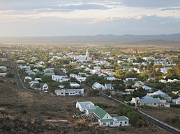
Beaufort West is a town in the Western Cape province in South Africa. It is the largest town in the arid Great Karoo region, and is known as the "Capital of the Karoo". It forms part of the Beaufort West Local Municipality, with 34,085 inhabitants in 2011.

The Western Australian economy is a state economy dominated by its resources and services sector and largely driven by the export of iron-ore, gold, liquefied natural gas and agricultural commodities such as wheat. Covering an area of 2.5 million km2, the state is Australia's largest, accounting for almost one-third of the continent. Western Australia is the nation's fourth most populous state, with 2.6 million inhabitants.

Grabouw is a town located in the Western Cape province of South Africa. Grabouw is located some 65 km south-east of Cape Town, over Sir Lowry's Pass from Somerset West, along the N2 highway.The town is the commercial centre for the vast Elgin Valley, the largest single export fruit-producing area in Southern Africa, which extends between the Hottentots-Holland, Kogelberg, Groenland, and Houwhoek Mountains. The town's population has grown rapidly, with 44 593 people in 2019 from 21 593 as listed by the 2001 census.

Middelburg is a town in the Eastern Cape province of South Africa, in the Great Karoo. It lies in the Upper Karoo, 1,279 m above sea level, with a population of 19,000. It falls under the Inxuba Yethemba Local Municipality, in the Chris Hani District Municipality.

Fraserburg is a town in the Karoo region of South Africa's Northern Cape province. It is located in the Karoo Hoogland Local Municipality. The town has some of the coldest winters in South Africa.

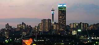
South Africa, officially the Republic of South Africa, is the southernmost country in Africa. It is bounded to the south by 2,798 kilometres (1,739 mi) of coastline that stretches along the South Atlantic and Indian Oceans; to the north by the neighbouring countries of Namibia, Botswana, and Zimbabwe; and to the east and northeast by Mozambique and Eswatini. It also completely enclaves the country Lesotho. It is the southernmost country on the mainland of the Old World, and the second-most populous country located entirely south of the equator, after Tanzania. South Africa is a biodiversity hotspot, with unique biomes, plant and animal life. With over 60 million people, the country is the world's 24th-most populous nation and covers an area of 1,221,037 square kilometres. Pretoria is the administrative capital, while Cape Town, as the seat of Parliament, is the legislative capital. Bloemfontein has traditionally been regarded as the judicial capital. The largest city, and site of highest court is Johannesburg.

Afrikaners are a Southern African ethnic group descended from predominantly Dutch settlers first arriving at the Cape of Good Hope in 1652. Until 1994, they dominated South Africa's politics as well as the country's commercial agricultural sector. Afrikaners make up approximately 5.2% of the total South African population, based upon the number of White South Africans who speak Afrikaans as a first language in the South African National Census of 2011. Afrikaans, South Africa's third most widely spoken home language, evolved as the mother tongue of Afrikaners and most Cape Coloureds. It originated in the Dutch vernacular of South Holland, incorporating words brought from the Dutch East Indies and Madagascar by slaves.

Calvinia is a regional town in the Northern Cape province of South Africa named after the French religious reformer Jean Calvin. The town falls under the Hantam Local Municipality which forms part of the Namakwa District Municipality. The Calvinia district is part of the Great Karoo region of South Africa. The town is just south of the Hantam mountains on the banks of the Oorlogskloof River.

The economy of the Western Cape in South Africa is dominated by the city of Cape Town, which accounted for 72% of the Western Cape's economic activity in 2016. The single largest contributor to the region's economy is the financial and business services sector, followed by manufacturing. Close to 30% of the gross regional product comes from foreign trade with agricultural products and wine dominating exports. High-tech industries, international call centres, fashion design, advertising and TV production are niche industries rapidly gaining in importance.