Princeton, North Carolina

Last updated

Princeton, North Carolina
Princeton, North Carolina.jpg
NCMap-doton-Princeton.PNG
Location of Princeton, North Carolina
Coordinates: 35°28′00″N78°09′41″W / 35.46667°N 78.16139°W / 35.46667; -78.16139
Country United States
State North Carolina
County Johnston
Government
  Mayor Stacy G. Johnson
Area
[1]
  Total1.16 sq mi (3.00 km2)
  Land1.16 sq mi (3.00 km2)
  Water0.00 sq mi (0.00 km2)
Elevation
[2]
151 ft (46 m)
Population
 (2020)
  Total1,315
  Density1,134.60/sq mi (438.05/km2)
Time zone UTC-5 (Eastern (EST))
  Summer (DST) UTC-4 (EDT)
ZIP code
27569
Area code 919
FIPS code 37-53820 [3]
GNIS feature ID2407161 [2]
Website www.myprincetonnc.com

Princeton is a town in Johnston County, North Carolina, United States. As of the 2010 census it had a population of 1,194. [4] Each May the town celebrates Princeton Community Day, a festival dedicated to promoting community involvement and town pride. The town holds municipal elections in November in odd-number years to elect its mayor and town council.

Contents

History

Princeton was incorporated as the town of Boon Hill in 1861, named in homage to the nearby Boon family plantation. It was renamed Princeton in 1873. [5] In 1914 the Gurley Mill was constructed as a corn and feed mill. By 2020 it was the oldest structure in Princeton, until it burned down in November. [6] The Princeton Graded School is listed on the National Register of Historic Places. [7]

Geography

Princeton is in eastern Johnston County. U.S. Route 70 runs along the northern edge of the town, leading northwest 9 miles (14 km) to Interstate 95 near Selma and southeast 11 miles (18 km) to Goldsboro.

According to the United States Census Bureau, the town has a total area of 1.0 square mile (2.7 km2), all land. [4]

Demographics

Historical population
CensusPop.Note
1890 248
1900 28113.3%
1910 35426.0%
1920 40313.8%
1930 50926.3%
1940 5120.6%
1950 60818.8%
1960 94855.9%
1970 1,04410.1%
1980 1,034−1.0%
1990 1,18114.2%
2000 1,066−9.7%
2010 1,19412.0%
2020 1,31510.1%
U.S. Decennial Census [8]

2020 census

Princeton racial composition [9]
RaceNumberPercentage
White (non-Hispanic)83063.12%
Black or African American (non-Hispanic)31924.26%
Native American 20.15%
Asian 80.61%
Pacific Islander 10.08%
Other/Mixed 544.11%
Hispanic or Latino 1017.68%

As of the 2020 United States census, there were 1,315 people, 497 households, and 246 families residing in the town.

2010 census

As of the census [10] of 2010, there were 1,194 people, 502 households, and 320 families residing in the town. The population density was 1,705.7 inhabitants per square mile (658.6/km2). There were 571 housing units at an average density of 815.7 per square mile (314.9/km2). The racial makeup of the town was 67.2% White, 25.5% African American, 5.6% from other races, and 1.7% from two or more races. Hispanic or Latino of any race were 5.9% of the population.

There were 502 households, out of which 28.0% had children under the age of 18 living with them, 41.6% were married couples living together, 18.5% had a female householder with no husband present, and 36.3% were non-families. 31.7% of all households were made up of individuals, and 15.3% had someone living alone who was 65 years of age or older. The average household size was 2.38 and the average family size was 3.00.

In the town, the population was spread out, with 26.0% under the age of 18, 8.5% from 18 to 24, 24.7% from 25 to 44, 23.6% from 45 to 64, and 17.3% who were 65 years of age or older. The median age was 38.4 years. For every 100 females, there were 76.6 males. For every 100 females age 18 and over, there were 74.4 males age 18 and over.

The median income for a household in the town was $32,143, and the median income for a family was $38,063. Males had a median income of $26,726 versus $20,690 for females. The per capita income for the town was $17,116. About 26.5% of families and 30.1% of the population were below the poverty line, including 56.3% of those under age 18 and 12.5% of those age 65 or over.

Education

Related Research Articles

<span class="mw-page-title-main">Burnham, Maine</span> Town in the state of Maine, United States

Burnham is a town in Waldo County, Maine, United States. The population was 1,096 at the 2020 census.

<span class="mw-page-title-main">Brookmont, Maryland</span> Census-designated place in Maryland, United States

Brookmont is a census-designated place and unincorporated area in Montgomery County, Maryland, United States. As of the 2020 census, it had a population of 3,751. Brookmont is often considered part of neighboring Bethesda because it falls within Bethesda's 20816 zip code.

<span class="mw-page-title-main">Eagle, New York</span> Town in New York, United States

Eagle is an incorporated town in Wyoming County, New York. The population was 1,194 at the 2000 census. The town is on the south border of the county.

<span class="mw-page-title-main">High Shoals, North Carolina</span> City in North Carolina, United States

High Shoals is a city in Gaston County, North Carolina, United States, named for the high rocky shoal across the Catawba River. The population was 696 at the 2010 census.

<span class="mw-page-title-main">Stokesdale, North Carolina</span> Town in North Carolina, United States

Stokesdale is a town in Guilford County, North Carolina, United States with small parts in the counties of Rockingham, Forsyth, and Stokes. The population was 5,924 at the 2020 census. Belews Lake is located nearby, and North Carolina Highway 68 and North Carolina Highway 65 both intersect U.S. Route 158 near the town's center.

<span class="mw-page-title-main">Jamesville, North Carolina</span> Town in North Carolina, United States

Jamesville is a town in Martin County, North Carolina, United States. The population was 491 at the 2010 census.

<span class="mw-page-title-main">Garysburg, North Carolina</span> Town in North Carolina, United States

Garysburg is a town in Northampton County, North Carolina, United States. The population was 1,057 at the 2010 census. It is part of the Roanoke Rapids, North Carolina Micropolitan Statistical Area.

<span class="mw-page-title-main">Bayboro, North Carolina</span> Town in North Carolina, United States

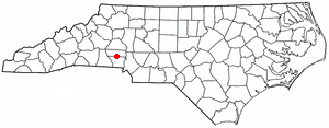
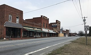
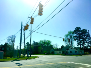
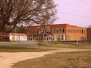
Bayboro is a town in Pamlico County, North Carolina, United States. The population was 1,161 at the 2020 U.S. census. It is the county seat of Pamlico County.

<span class="mw-page-title-main">Parkton, North Carolina</span> Town in North Carolina, United States

Parkton is a town in Robeson County, North Carolina, Lumberton metro area, United States. The town was so named because it was a place where farmers tied up their horses while waiting for the train. As of the 2020 census, the town population was 504.

<span class="mw-page-title-main">Stanfield, North Carolina</span> Town in North Carolina, United States

Stanfield is a town in Stanly County, North Carolina, United States. The population was 1,486 at the 2010 census.

<span class="mw-page-title-main">Hilda, South Carolina</span> Town in South Carolina, United States

Hilda is a town in Barnwell County, South Carolina, United States. The population was 447 at the 2010 census..

<span class="mw-page-title-main">Holly Hill, South Carolina</span> Town in South Carolina, United States

Holly Hill is a town in Orangeburg County, South Carolina, United States. The population was 1,277 at the 2010 census. Prior to 1910 it was located in the northwest portion of Saint James Goose Creek Township.

<span class="mw-page-title-main">Campobello, South Carolina</span> Town in South Carolina, United States

Campobello is a town in Spartanburg County, South Carolina, United States, along the South Pacolet River. The population was 502 at the 2010 census.

<span class="mw-page-title-main">Landrum, South Carolina</span> City in South Carolina, United States

Landrum is a city in Spartanburg County, South Carolina, United States. The population was 2,376 at the 2010 census.

<span class="mw-page-title-main">Boones Mill, Virginia</span> Town in Virginia, United States

Boones Mill is a town in Franklin County, Virginia, United States. The population was 239 in 2018, down from 285 at the 2000 census.

<span class="mw-page-title-main">Easton, Adams County, Wisconsin</span> Town in Wisconsin, United States

Easton is a town in Adams County in the U.S. state of Wisconsin. The population was 1,130 at the 2010 census. The unincorporated communities of Brookside and White Creek are located in the town.

<span class="mw-page-title-main">Tobaccoville, North Carolina</span> Village in North Carolina, United States

Tobaccoville is a village in Forsyth and Stokes counties in the U.S. state of North Carolina. The population was 2,209 at the 2020 census. While a Tobaccoville post office was established in 1879, the village was not incorporated until 1991, as a defense against forced annexation of the area by the nearby city of King.

<span class="mw-page-title-main">Weddington, North Carolina</span> Town in North Carolina, United States

Weddington is a suburban town in Union County, North Carolina, United States. The population was 9,459 at the 2010 census. It is a suburb in the Charlotte metropolitan area. The current mayor of Weddington is Jim Bell.

<span class="mw-page-title-main">Rib Mountain, Wisconsin</span> Village in Wisconsin, United States

Rib Mountain is a village located in Marathon County, Wisconsin, United States. The population was 7,313 at the 2020 census. A suburb of Wausau, it is part of the Wausau Metropolitan Statistical Area. The census-designated place of Rib Mountain is located in the village.

<span class="mw-page-title-main">Tomah (town), Wisconsin</span> Town in Wisconsin, United States

Tomah is a town in Monroe County, Wisconsin, United States. The population was 1,488 at the 2020 census. It lies adjacent to the city of Tomah.

References

  1. "ArcGIS REST Services Directory". United States Census Bureau. Retrieved September 20, 2022.
  2. 1 2 U.S. Geological Survey Geographic Names Information System: Princeton, North Carolina
  3. "U.S. Census website". United States Census Bureau . Retrieved January 31, 2008.
  4. 1 2 "Geographic Identifiers: 2010 Census Summary File 1 (G001): Princeton town, North Carolina". American Factfinder. U.S. Census Bureau. Archived from the original on February 13, 2020. Retrieved October 12, 2018.
  5. Powell 1976, p. 396.
  6. "Fire engulfs Princeton's oldest building, cause remains unknown". WRAL-TV. Capitol Broadcasting Company. November 18, 2020. Retrieved November 25, 2021.
  7. "National Register Information System". National Register of Historic Places . National Park Service. July 9, 2010.
  8. "Census of Population and Housing". Census.gov. Retrieved June 4, 2015.
  9. "Explore Census Data". data.census.gov. Retrieved December 23, 2021.
  10. 2010 Census Fact Finder Data Retrieved on September 12, 2013.

Works cited