Puskwaskau River

Last updated
Puskwaskau River
CountryFlag of Canada.svg  Canada
Physical characteristics
Main source Puskwaskau Lake
715 meters (2,346 ft)
55°16′44″N117°39′09″W / 55.27887°N 117.65259°W / 55.27887; -117.65259 (Puskwaskau Lake)
River mouth Smoky River
440 meters (1,440 ft)
55°29′03″N118°09′23″W / 55.48403°N 118.15646°W / 55.48403; -118.15646 (Puskwaskau River mouth) Coordinates: 55°29′03″N118°09′23″W / 55.48403°N 118.15646°W / 55.48403; -118.15646 (Puskwaskau River mouth)

The Puskwaskau River is a short river in Northern Alberta, Canada. It is a tributary of the Smoky River flowing westwards in the Peace River Country. Its waters flow through the Smoky River, Peace River, Slave River, Great Slave Lake and Mackenzie River into the Arctic Ocean.

Northern Alberta geographical object

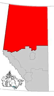
Northern Alberta is a region located in the Canadian province of Alberta.

Canada Country in North America

Canada is a country in the northern part of North America. Its ten provinces and three territories extend from the Atlantic to the Pacific and northward into the Arctic Ocean, covering 9.98 million square kilometres, making it the world's second-largest country by total area. Canada's southern border with the United States, stretching some 8,891 kilometres (5,525 mi), is the world's longest bi-national land border. Its capital is Ottawa, and its three largest metropolitan areas are Toronto, Montreal, and Vancouver. As a whole, Canada is sparsely populated, the majority of its land area being dominated by forest and tundra. Consequently, its population is highly urbanized, with over 80 percent of its inhabitants concentrated in large and medium-sized cities, with 70% of citizens residing within 100 kilometres (62 mi) of the southern border. Canada's climate varies widely across its vast area, ranging from arctic weather in the north, to hot summers in the southern regions, with four distinct seasons.

Smoky River river in Canada

The Smoky River is a river in western Alberta, Canada. It is a major tributary of the Peace River. The descriptive name refers to the presence of "smouldering beds of coal in the riverbank" noted by the Cree Indians.

Contents

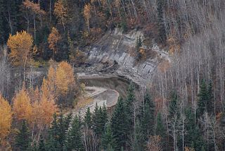
The name of the river originates from the Cree word for short grass. [1] The Puskwaskau Formation, a stratigraphical unit of the Western Canadian Sedimentary Basin, was named for the river.

Cree language Algonquian language spoken by people across Canada, from the Northwest Territories and Alberta to Labrador, making it the aboriginal language with the highest number of speakers in Canada

Cree is a dialect continuum of Algonquian languages spoken by approximately 117,000 people across Canada, from the Northwest Territories to Alberta to Labrador. If classified as one language, it is the aboriginal language with the highest number of speakers in Canada. The only region where Cree has any official status is in the Northwest Territories, alongside eight other aboriginal languages. There, Cree is spoken mainly in Fort Smith and Hay River.

Western Canadian Sedimentary Basin

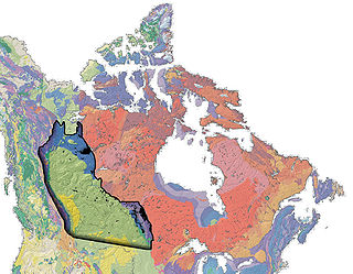
The Western Canadian Sedimentary Basin (WCSB) is a vast sedimentary basin underlying 1,400,000 square kilometres (540,000 sq mi) of Western Canada including southwestern Manitoba, southern Saskatchewan, Alberta, northeastern British Columbia and the southwest corner of the Northwest Territories. It consists of a massive wedge of sedimentary rock extending from the Rocky Mountains in the west to the Canadian Shield in the east. This wedge is about 6 kilometres (3.7 mi) thick under the Rocky Mountains, but thins to zero at its eastern margins. The WCSB contains one of the world's largest reserves of petroleum and natural gas and supplies much of the North American market, producing more than 16,000,000,000 cubic feet (450,000,000 m3) per day of gas in 2000. It also has huge reserves of coal. Of the provinces and territories within the WCSB, Alberta has most of the oil and gas reserves and almost all of the oil sands.

Course

The river originates from the Puskwaskau Lake in the Sturgeon Heights, at an elevation of 715 meters (2,346 ft), north-west from Valleyview. It flows north-west and receives the waters of Little Puskwaskau River before being crossed by Highway 676. It continues flowing in a western direction through a 150 meters (490 ft) deep canyon before it empties in the Smoky River, west of Teepee Creek, at an elevation of 440 meters (1,440 ft), 40 kilometers (25 mi) west of its origin.

Valleyview, Alberta Town in Alberta, Canada

Valleyview is a town in northwest Alberta, Canada within the Municipal District of Greenview No. 16 and Census Division No. 18.

Tributaries

See also

Related Research Articles

Athabasca River river in Canada

The Athabasca River originates from the Columbia Glacier of the Columbia Icefield in Jasper National Park in Alberta, Canada. The impressive and scenic Athabasca Falls is located upstream about 30 km (19 mi) from the Jasper townsite.

Geography of Alberta

Alberta is a Canadian province. Located in Western Canada, the province has an area of 661,190 square kilometres (255,290 sq mi) and is bounded to the south by the U.S. state of Montana along 49° north for 298 kilometres (185 mi); to the east at 110° west by the province of Saskatchewan for 1,223 kilometres (760 mi); and at 60° north the Northwest Territories for 644 kilometres (400 mi). The southern half of the province borders British Columbia along the Continental Divide of the Americas on the peaks of the Rocky Mountains, while the northern half borders British Columbia along the 120th meridian west.

Peace River river in Alberta and British Columbia

The Peace River is a 1,923-kilometre-long (1,195 mi) river in Canada that originates in the Rocky Mountains of northern British Columbia and flows to the northeast through northern Alberta. The Peace River joins the Athabasca River in the Peace-Athabasca Delta to form the Slave River, a tributary of the Mackenzie River. The Finlay River, the main headwater of the Peace River, is regarded as the ultimate source of the Mackenzie River. The combined Finlay–Peace–Slave–Mackenzie river system is the 13th longest river system in the world.

Hay River (Canada) river in Alberta and Northwest Territories, Canada

The Hay River is a large river in northern Alberta and southern Northwest Territories, Canada.

Little Smoky River river in Canada

The Little Smoky River is a tributary of the Smoky River in west-central Alberta, Canada.

Wapiti River river in Canada

The Wapiti River is a river in eastern British Columbia and western Alberta, Canada. It is a major tributary of the Smoky River, located in the southern area of the Peace River Basin.

Kiskatinaw River river in Canada

Kiskatinaw is a tributary of the Peace River in northeastern British Columbia, Canada.

The Kakwa River is a tributary of the Smoky River in western Alberta, Canada.

Cutbank River is a river in western Alberta, Canada. It is a major tributary of the Smoky River.

Rosebud River river in Canada

The Rosebud River is a major tributary of the Red Deer River in Alberta, Canada.

The Spirit River is a river in northern Alberta, Canada. The name is a translation of the Cree words Chepe Sepi, meaning ghost or spirit.

The Bad Heart River is a short river in northern Alberta, Canada. It is a tributary of the Smoky River.

The Kakisa River is a major tributary of the Mackenzie River in the Northwest Territories of Canada.

The Notikewin River is a tributary of the Peace River in northern Alberta, Canada. The Notikewin Provincial Park is established at the mouth of the river.

Redwillow River river in Canada

The Redwillow River is a tributary of the Wapiti River in northern Alberta and north-eastern British Columbia, Canada. It flows through the Pouce Coupe Prairie, in the south of Peace River Country.

The Cadotte River is a tributary of the Peace River in Northern Alberta, Canada.

Heart River (Alberta) river in Canada

The Heart River is a river in northern Alberta, Canada. It is a major tributary of the Peace River.

Pat's Creek is a tributary of the Peace River in northern Alberta, Canada whose mouth is located within the Town of Peace River.

References

  1. Alberta Land Surveyor History. "Place names" . Retrieved 2010-08-18.