Hayden is a town in Gila and Pinal counties in Arizona, United States. According to the 2010 census, the population of the town was 662.

Kearny is a town in Pinal County, Arizona, United States. The town was named after General Stephen Watts Kearny, who passed through the area on November 7, 1846, while leading 100 dragoons to California. According to the 2010 census, the population of the town is 1,950. The economic base of Kearny and nearby towns is the Ray mine and Hayden Smelter, both owned and operated by ASARCO.

Ely is the largest city and county seat of White Pine County, Nevada, United States. Ely was founded as a stagecoach station along the Pony Express and Central Overland Route. In 1906 copper was discovered. Ely's mining boom came later than the other towns along US 50. The railroads connecting the transcontinental railroad to the mines in Austin, Nevada and Eureka, Nevada have long been removed, but the railroad to Ely is preserved as a heritage railway by the Nevada Northern Railway and known as the Ghost Train of Old Ely. As of the 2020 census, the population was 3,924.

Swansea is a ghost town in La Paz County in the U.S. state of Arizona. It was settled circa 1909 in what was then the Arizona Territory. It served as a mining town as well as a location for processing and smelting the copper ore taken from the nearby mines.

Kennecott, also known as Kennicott and Kennecott Mines, is an abandoned mining camp in the Copper River Census Area in the U.S. state of Alaska that was the center of activity for several copper mines. It is located beside the Kennicott Glacier, northeast of Valdez, inside Wrangell-St. Elias National Park and Preserve. The camp and mines are now a National Historic Landmark District administered by the National Park Service.

Kennecott Utah Copper LLC (KUC), a division of Rio Tinto Group, is a mining, smelting, and refining company. Its corporate headquarters are located in South Jordan, Utah. Kennecott operates the Bingham Canyon Mine, one of the largest open-pit copper mines in the world in Bingham Canyon, Salt Lake County, Utah. The company was first formed in 1898 as the Boston Consolidated Mining Company. The current corporation was formed in 1989. The mine and associated smelter produce 1% of the world's copper.
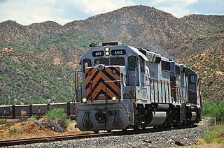
The Copper Basin Railway is an Arizona short-line railroad that operates from a connection with the Union Pacific Railroad (UP) at Magma to Winkelman, in 54 miles (87 km) of length. The railroad also has a 7-mile (11 km) branch line that runs from Ray Junction to Ray, Arizona. There was formerly an interchange with the San Manuel Arizona Railroad (SMA) at Hayden. The CBRY exists primarily to serve a copper mine. L. S. “Jake” Jacobson was the President and Chief Operating Officer, retiring in 2020 after more than 30 years in his position. In summer 2006, ASARCO Copper Corporation purchased the entire railroad.

Ruby is a ghost town in Santa Cruz County, Arizona, United States. It was founded as a mining town in Bear Valley, originally named Montana Camp, so named because the miners were mining at the foot of Montana Peak.

Ruth is a census-designated place (CDP) in White Pine County, Nevada, United States. Founded in 1903, it had a population of 440 at the 2010 census.

Bingham Canyon was a city formerly located in southwestern Salt Lake County, Utah, United States, in a narrow canyon on the eastern face of the Oquirrh Mountains. The Bingham Canyon area boomed during the first years of the twentieth century, as rich copper deposits in the canyon began to be developed, and at its peak the city had approximately 15,000 residents. The success of the local mines eventually proved to be the town's undoing, however: by the mid-twentieth century, the huge open-pit Bingham Canyon Mine began encroaching on the land of the community, causing residents to relocate. By the 1970s, almost the entirety of the town had been devoured by the mine, and the few remaining residents voted to disincorporate and abandon the community. No trace of Bingham Canyon remains today.
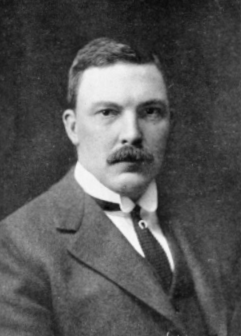
Stephen Birch (1873–1950) was a President of the Kennecott Copper Company.

Helvetia is a ghost town in Pima County, Arizona, United States that was settled in 1891 and abandoned in the early 1920s. Helvetia is an ancient name for Switzerland. Today, only the Ray Mine and cemetery are visitable, as the rest of the town has been fenced off due to active mining operations.

The Mineral Park mine is a large open pit copper mine located in the Cerbat Mountains 14 miles northwest of Kingman, Arizona, in the southwestern United States. A 2013 report said that Mineral Park has an estimated reserves of 389 million tonnes of ore grading 0.14% copper and 31 million oz of silver.

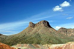
The Ray mine is a large copper mine in Pinal County, Arizona, near the town of Kearny, in the southwestern United States. ASARCO, a subsidiary of Grupo México, currently owns the mine, which it acquired from Kennecott Copper in 1986.

Twin Buttes is a populated place on the east flank of the Sierrita Mountains approximately twenty miles south of Tucson, in Pima County, Arizona, United States. Named after a prominent hill located next to the town, Twin Buttes was founded as a small mining town circa 1903 and abandoned around 1930. Much of the actual town site is now buried underneath mine tailings, and all that remains is the Twin Buttes Cemetery.

San Xavier is a populated place in Pima County, Arizona, United States, situated seventeen miles southwest of Tucson, and six miles northwest of Sahuarita. Originally a small silver mining camp from the 1880s, today San Xavier is little more than a collection of rural homes and partially abandoned mines. The ghost towns of Azurite and Mineral Hill were located about one mile north of San Xavier. Twin Buttes was five miles southeast.

Kimberly is a ghost town in the state of Nevada. A mining town situated west of Riepetown and east of the former town of Veteran, Kimberly once boasted over 500 inhabitants.

Duquesne is a ghost town in the Patagonia Mountains in eastern Santa Cruz County, Arizona, near the international border with Sonora, Mexico. The town, which is currently under private ownership and closed to the public although the roads are almost all public, was once the headquarters of the Duquesne Mining and Reduction Company and is the site of the Bonanza Mine. Washington Camp is approximately one mile northwest of Duquesne and was where the mine's reduction plant was located.

Salero is a ghost town in the Santa Rita Mountains of Santa Cruz County, Arizona. As one of the best preserved ghost towns remaining in Arizona, Salero is located on private property of the Salero Ranch and is not open to visitors.
Sonora was a community in Pinal County, Arizona, until its residents were moved to Kearny, Arizona and the site was demolished to expand the Ray mine. It has an estimated elevation of 2,293 feet (699 m) above sea level.