Phoenix is the capital and most populous city of the U.S. state of Arizona, with 1,608,139 residents as of 2020. It is the fifth-most populous city in the United States and the most populous state capital in the country.

Imperial County is a county located on the southeast border of the U.S. state of California. As of the 2020 census, the population was 179,702, making it the least populous county in Southern California. The county seat and largest city is El Centro. Imperial is the most recent California county to be established, as it was created in 1907 out of portions of San Diego County.

Goodyear is a city in Maricopa County, Arizona, United States. It is a suburb of Phoenix and at the 2020 census had a population of 95,294, up from 65,275 in 2010 and 18,911 in 2000. It was the third-fastest-growing city in Arizona between 1990 and 2000.

Mesa is a city in Maricopa County, Arizona, United States. It is the third-most populous city in Arizona, after Phoenix and Tucson, the 36th-most populous city in the U.S., and the most populous city that is not a county seat. The city is home to 504,258 people as of 2020. It is the most populous city in the East Valley of the Phoenix metropolitan area. It is bordered by Tempe on the west, the Salt River Pima–Maricopa Indian Community on the north, Chandler and Gilbert on the south along with Queen Creek, and Apache Junction on the east.

Tempe is a city in Maricopa County, Arizona, United States, with the Census Bureau reporting a 2020 population of 180,587. The city is named after the Vale of Tempe in Greece. Tempe is located in the East Valley section of metropolitan Phoenix; it is bordered by Phoenix and Guadalupe on the west, Scottsdale and the Salt River Pima–Maricopa Indian Community on the north, Chandler on the south, and Mesa on the east. Tempe is also the location of the main campus of Arizona State University.

Village of Oak Creek is an unincorporated community located within Big Park a census-designated place (CDP) in Yavapai County, Arizona, United States. The population was 6,147 at the 2010 census, up from 5,245 in 2000. Big Park is the name of the CDP while the community is more commonly known as the Village of Oak Creek (VOC), and is a bedroom community for Sedona, located seven miles away. Tourism and service to retirees and second-home owners are the basis for the local economy. Big Park, the pioneers' name for the large open area that became the Village of Oak Creek in the early 1960s, is set among scenic red-rock buttes and canyons. The Bell Rock scenic area adjoins the north end of VOC, and the town is surrounded by the Coconino National Forest. A Forest Service Visitor Center is located at the south end of VOC.

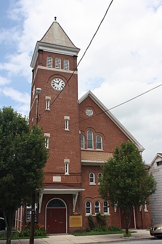
Nesquehoning is a borough in Carbon County, Pennsylvania, United States. It is part of Northeastern Pennsylvania. The population was 3,336 at the 2020 census.

Wellesley is a town in Norfolk County, Massachusetts, United States. Wellesley is part of Greater Boston. The population was 29,550 at the time of the 2020 census. Wellesley College, Babson College, and a campus of Massachusetts Bay Community College are located in the town.

Kenansville, Florida, United States, is an unincorporated community in Osceola County. It is approximately sixty-one miles southeast of the Greater Orlando urban region. The zip code is 34739.

Meadview is an unincorporated community and census-designated place (CDP) in Mohave County, Arizona, United States, located near Lake Mead. As of the 2020 census, Meadview had 1,420 residents, up from 1,224 as of 2010. It was founded in the 1960s as a retirement community and is still largely one, as well as a vacation spot for people coming to enjoy Lake Mead.

Indian Wells is a census-designated place in Navajo County, Arizona, United States. Indian Wells Elementary School is located in the town, it serves 600 students. It is also the name of the local Navajo chapter of the Navajo Nation Council. Indian Wells is served by a post office with the ZIP code of 86031. The ZIP Code Tabulation Area for ZIP Code 86031 had a population of 1,856 at the 2010 census, with 255 in Indian Wells itself.
Pinnacle West Capital Corporation is an American utility holding company that owns Arizona Public Service (APS) and Bright Canyon Energy. It is publicly traded on the New York Stock exchange and a component of the S&P 500 stock market index. APS is the largest utility company in Arizona and is regulated by the Arizona Corporation Commission (ACC).

The Solana Generating Station is a solar power plant near Gila Bend, Arizona, about 70 miles (110 km) southwest of Phoenix. It was completed in 2013. When commissioned, it was the largest parabolic trough plant in the world, and the first U.S. solar plant with molten salt thermal energy storage. Built by the Spanish company Abengoa Solar, the project can produce up to 280 megawatts (MW) gross, supplied by two 140 MW gross (125 MW net) steam turbine generators: enough electricity to meet the needs of approximately 70,000 homes and obviate the emission of roughly 475,000 tons of CO2 every year. Its name is the Spanish term for "sunny spot".

Solar power in Arizona has the potential to, according to then-Governor Janet Napolitano, make Arizona "the Persian Gulf of solar energy". In 2012, Arizona had 1,106 MW of photovoltaic (PV) solar power systems, and 6 MW of concentrated solar power (CSP), bringing the total to over 1,112 megawatts (MW) of solar power. As an example, the Solana Generating Station, a 280 MW parabolic trough solar plant, when commissioned in 2013, was the largest parabolic trough plant in the world and the first U.S. solar plant with molten salt thermal energy storage.
In 2016, Arizona had 268 megawatts (MW) of wind powered electricity generating capacity, producing 0.5% of in-state generated electricity.

Waterflow is an unincorporated community and census-designated place in San Juan County, New Mexico, United States on the north side of the San Juan River. It is immediately west of Fruitland and north across the river from the Navajo Nation. It is east of Shiprock.

Picacho is an unincorporated community and census-designated place in Pinal County, Arizona, United States. The population was 250 at the 2020 census.

East Globe is a census-designated place in Gila County, Arizona, United States. As of the 2010 census it had a population of 226.
ASU Campus Metabolism is a website managed by Arizona State University, demonstrating Energy monitoring and targeting through use of real-time and historic energy use data of buildings on the campus in Tempe, Arizona. The site displays data from an Energy Information System in order to support education, research, operations and outreach regarding sustainability of operations on the ASU Tempe campus. The site is part of a plan for the campus to be carbon-neutral by 2025.


