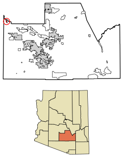
Green Valley is an unincorporated community and census-designated place (CDP) in Pima County, Arizona, United States. The population was 22,616 at the 2020 census.

Sonoita is a census-designated place (CDP) in Santa Cruz County, Arizona, United States. The population was 803 at the 2020 census.

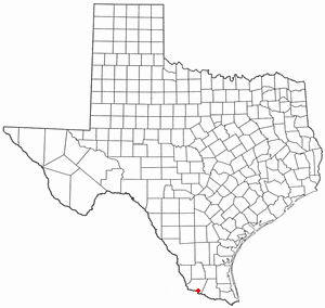
Tubac is a census-designated place (CDP) in Santa Cruz County, Arizona, United States. The population was 1,191 at the 2010 census. The place name "Tubac" is an English borrowing from a Hispanicized form of the O'odham name Cuwak, which translates into English as "place of dark water". When first taken into Spanish speech, it was spelled Tubaca. Finally, over time, the latter "a" was dropped. Tubac is situated on the Santa Cruz River.

Westmont is an unincorporated community in Los Angeles County, California, a part of the South Los Angeles area, just east of Inglewood. The population was 33,913 at the 2020 census, up from 31,853 at the 2010 census. For statistical purposes, the United States Census Bureau has defined Westmont as a census-designated place (CDP).

Aromas is an unincorporated community and census-designated place (CDP) in Monterey County and San Benito County, California, United States. The population was 2,708 at the 2020 census.

Lexington Hills is a census-designated place and an unincorporated area in Santa Clara County, California, United States. The population was 2,492 at the 2020 census. The area is located in the Santa Cruz Mountains, about five miles south of Los Gatos and about 14 miles (23 km) north of Santa Cruz. Lexington Hills is the name assigned by the United States Census Bureau to the area, which actually comprises several small communities, including Redwood Estates, Holy City, Chemeketa Park, and Aldercroft Heights.

San Martin or San Martín is a village and census-designated place (CDP) in Santa Clara County, California, in the southern Santa Clara Valley. Located to the south of Morgan Hill and north of Gilroy, San Martin is characterized by ranches, wineries, and orchards, as well as large estates in the foothills of the Santa Cruz Mountains.

Aptos is an unincorporated town in Santa Cruz County, California, United States. The town is made up of several small villages, which together form Aptos: Aptos Hills-Larkin Valley, Aptos Village, Cabrillo, Seacliff, Rio del Mar, and Seascape. Together, they have a combined population of 24,402.

Ben Lomond is a census-designated place (CDP) in Santa Cruz County, California, United States, and also the name of the mountain to the west. The CDP includes the communities of Glen Arbor and Brackney. The population was 6,337 at the 2020 census.

Day Valley is a census-designated place (CDP) in Santa Cruz County, California, United States. The population was 3,409 at the 2010 census.

Felton is a census-designated place (CDP) in Santa Cruz County, California, United States. The population was 4,489 as of 2020 census and according to the United States Census Bureau, the CDP has a total area of 4.6 square miles (12 km2), all of it land.
Rio del Mar is an unincorporated village in Santa Cruz County, California. Rio del Mar is one of several small villages that form the unincorporated community of Aptos, California. Its population was 9,128 as of the 2020 United States census. For statistical purposes, the United States Census Bureau has defined Rio del Mar as a census-designated place (CDP).
Soquel is an unincorporated town and census-designated place (CDP) in Santa Cruz County, California, located on the northern coast of Monterey Bay. The population was 9,980 at the 2020 census.
Santa Cruz is a former census-designated place (CDP) in Starr County, Texas, United States. The population was 630 at the 2000 census. Prior to the 2010 census, this CDP was deleted and parts were taken to form El Chaparral and Santa Rosa CDPs. A new CDP of the same name was created that does not contain any part of the old CDP.

Davenport is a census-designated place (CDP) in Santa Cruz County, California. Davenport sits at an elevation of 259 feet (79 m). The 2020 United States census reported Davenport's population was 388.

Rio Rico is an unincorporated community and census-designated place (CDP) in Santa Cruz County, Arizona, United States. The population was 18,962 at the 2010 census. The Rio Rico CDP replaced the former CDPs of Rio Rico Northwest, Rio Rico Northeast, Rio Rico Southwest, and Rio Rico Southeast.
Lompico is a census-designated place (CDP) in Santa Cruz County, California. Lompico sits at an elevation of 968 feet (295 m). Lompico shares the 95018 ZIP code with Felton. Lompico was founded in 1927. It is in area code 831. The 2010 United States census reported Lompico's population was 1,137.
Paradise Park is a census-designated place (CDP) in Santa Cruz County, California. Paradise Park sits at an elevation of 92 feet (28 m). The 2020 United States census reported Paradise Park's population was 550, which is up from 389 people in the 2010 census.

Gila Crossing is a census-designated place (CDP) in Maricopa County, Arizona, United States, within the Gila River Indian Community south of Komatke. The population was 636 at the 2020 census.
Pajaro Dunes is a census-designated place (CDP) in Santa Cruz County, California. Pajaro Dunes is situated at an elevation of 13 feet above sea level. The 2020 United States census reported Pajaro Dunes' population was 122.