Related Research Articles

Whatì, officially the Tłı̨chǫ Community Government of Whatì is a First Nations community in the North Slave Region of the Northwest Territories, Canada. Whatì is located by Lac La Martre, about 164 km (102 mi) northwest of the territorial capital of Yellowknife.

Northern Canada, colloquially the North or the Territories, is the vast northernmost region of Canada variously defined by geography and politics. Politically, the term refers to the three territories of Canada: Yukon, Northwest Territories and Nunavut. This area covers about 48 per cent of Canada's total land area, but has less than 1 per cent of Canada's population.

Tulita, which in Slavey means "where the rivers or waters meet," is a hamlet in the Sahtu Region of the Northwest Territories, Canada. It was formerly known as Fort Norman, until 1 January 1996. It is located at the junction of the Great Bear River and the Mackenzie River; the Bear originates at Great Bear Lake adjacent to Deline.

Kitikmeot Region is an administrative region of Nunavut, Canada. It consists of the southern and eastern parts of Victoria Island with the adjacent part of the mainland as far as the Boothia Peninsula, together with King William Island and the southern portion of Prince of Wales Island. The regional centre is Cambridge Bay.
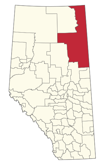
The Regional Municipality of Wood Buffalo is a specialized municipality in northeast Alberta, Canada. It is the second largest municipality in Alberta by area and is home to oil sand deposits known as the Athabasca oil sands.

Fort Smith is a town in the South Slave Region of the Northwest Territories (NWT), Canada. It is located in the southeastern portion of the Northwest Territories, on the Slave River and adjacent to the Alberta border along the 60th parallel north.

Fort Resolution is a hamlet in the South Slave Region of the Northwest Territories, Canada. The community is situated at the mouth of the Slave River, on the shores of Great Slave Lake, and at the end of the Fort Resolution Highway. It is the headquarters of the Deninu Kųę́ First Nation, whose Chief is Louis Balsillie.
Fort Providence is a hamlet in the South Slave Region of the Northwest Territories, Canada. Located west of Great Slave Lake, it has all-weather road connections by way of the Yellowknife Highway branch off the Mackenzie Highway, and the Deh Cho Bridge opened November 30, 2012, near Fort Providence over the Mackenzie. The bridge replaced the ice bridge and ferry, enabling year-round crossing of the river.

Dettah, sometimes, incorrectly, as Detah, is a First Nations community in the North Slave Region of the Northwest Territories, Canada. Located just southeast of the capital of Yellowknife, it is a 6.5 km (4.0 mi) drive from that city by ice road across the north arm of Great Slave Lake in winter or a 27 km (17 mi) drive via the Ingraham Trail, year-round. The name means 'Burnt Point' in the Dogrib language and refers to a traditional fishing camp used by the Dene for hundreds of years.

Behchokǫ̀, officially the Tłı̨chǫ Community Government of Behchokǫ̀, is a community in the North Slave Region of the Northwest Territories, Canada. Behchokǫ̀ is located on the Yellowknife Highway, on the northwest tip of Great Slave Lake, approximately 110 km (68 mi) northwest of Yellowknife.
Kakisa is a "Designated Authority" in the South Slave Region of the Northwest Territories, Canada. The community is located on Kakisa Lake, and is southeast of Fort Providence. Originally located at Tathlina Lake, the community moved, in 1962, to the present location in order to be closer to the Mackenzie Highway and is linked by a 13 km (8.1 mi) all-weather road.

Mackenzie County is a specialized municipality in northern Alberta, Canada. It is located in Census Division 17, along the Mackenzie Highway. The municipal office is located in the hamlet of Fort Vermilion.

The South Slave Region is one of five administrative regions in the Northwest Territories of Canada. According to Municipal and Community Affairs the region consists of seven communities with the regional office situated in Fort Smith and a sub-office in Hay River. With the exception of Enterprise and Hay River the communities are predominantly First Nations.

Red Earth Creek is a hamlet in Alberta, Canada within the Municipal District of Opportunity No. 17. It is located east of Highway 88, between the Town of Slave Lake and the Hamlet of Fort Vermilion, and has an elevation of 520 metres (1,710 ft).
Smith is a hamlet in northern Alberta, Canada within the Municipal District of Lesser Slave River No. 124. It is located on Highway 2A, approximately 182 kilometres (113 mi) northwest of Edmonton, at the confluence of the Lesser Slave River and the Athabasca River.
Region 1 is the name of a Statistics Canada census division, one of six in the Northwest Territories, Canada. It was introduced in the 2011 census, along with Regions 2, 3, 4, 5 and 6, resulting in the abolition of the former census divisions of Fort Smith Region and Inuvik Region. Unlike in some other provinces, census divisions do not reflect the organization of local government in the Northwest Territories. These areas exist solely for the purposes of statistical analysis and presentation; they have no government of their own.
Region 2 is the name of a Statistics Canada census division, one of six in the Northwest Territories, Canada. It was introduced in the 2011 census, along with Regions 1, 3, 4, 5 and 6, resulting in the abolition of the former census divisions of Fort Smith Region and Inuvik Region. Unlike in some other provinces, census divisions do not reflect the organization of local government in the Northwest Territories. These areas exist solely for the purposes of statistical analysis and presentation; they have no government of their own.
Region 6 is the name of a Statistics Canada census division, one of six in the Northwest Territories, Canada. It was introduced in the 2011 census, along with Regions 1, 2, 3, 4, and 5, resulting in the abolition of the former census divisions of Fort Smith Region and Inuvik Region. It includes the city of Yellowknife, and has the largest population by far of any of the six census divisions. Unlike in some other provinces, census divisions do not reflect the organization of local government in the Northwest Territories. These areas exist solely for the purposes of statistical analysis and presentation; they have no government of their own.
Region 3 is the name of a Statistics Canada census division, one of six in the Northwest Territories, Canada. It was introduced in the 2011 census, along with Regions 1, 2, 4, 5, and 6, resulting in the abolition of the former census divisions of Fort Smith Region and Inuvik Region. Unlike in some other provinces, census divisions do not reflect the organization of local government in the Northwest Territories. These areas exist solely for the purposes of statistical analysis and presentation; they have no government of their own.
Region 4 is the name of a Statistics Canada census division, one of six in the Northwest Territories, Canada. It was introduced in the 2011 census, along with Regions 1, 2, 3, 5, and 6, resulting in the abolition of the former census divisions of Fort Smith Region and Inuvik Region. Unlike in some other provinces, census divisions do not reflect the organization of local government in the Northwest Territories. These areas exist solely for the purposes of statistical analysis and presentation; they have no government of their own.
References
- ↑ NWT Department of Environment and Natural Resources: Administrative Regions
- ↑ Map: Region 5, Region (Census Division), Northwest Territories
- ↑ "Region 5, Northwest Territories (Code 6105) Census Profile". 2011 census . Government of Canada - Statistics Canada. 2012.
- ↑ "None". 29 May 2012.
- ↑ "Population and dwelling counts: Canada and census divisions". Statistics Canada. February 9, 2022. Retrieved April 3, 2022.
- ↑ Geographic hierarchy: Region 5 (Region)