Dehcho Region

Last updated
Dehcho Region
Liard River at Blackstone Territorial Park NT.jpg
NWT Locator Deh Cho.svg
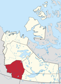
Location within the Northwest Territories
CountryCanada
Territory Northwest Territories
Federal riding Northwest Territories
Territorial riding Nahendeh
Regional office [1] Fort Simpson
Area
  Total194,494 km2 (75,094.5 sq mi)
Population
 (2016)
  Total2,073
Time zone UTC−07:00 (MST)
  Summer (DST) UTC−06:00 (DST)

The Dehcho Region[ pronunciation? ] or Deh Cho is one of five administrative regions in the Northwest Territories of Canada. According to Municipal and Community Affairs the region consists of six communities with the regional office situated in Fort Simpson. [1] All communities in the Dehcho are predominantly Dehcho First Nations. [2] [3]

Contents

Communities

The Dehcho Region includes the following communities:

Communities of the Dehcho Region
CommunityDemographics (2016)
Name [4] Type [5] Census [6] Aboriginal population profile [7]
OfficialTraditionalTotal First Nations Métis Inuit Other
Fort Liard Echaot'ı̨e Kų́ę́Hamlet50044015085
Fort Simpson Łı́ı́dlı̨ Kų́ę́Village1,2028008520570
Jean Marie River Tthek'éhdélı̨Designated authority7775000
Nahanni Butte TthenáágóDesignated authority87851000
Sambaa Kʼe Designated authority886010035
Wrigley Pedzéh Kı̨́Designated authority11911001010
Welcome to Fort Simpson Welcome to Fort Simpson (5878148063).jpg
Welcome to Fort Simpson
Historical population
YearPop.±%
20012,293    
20022,300+0.3%
20032,258−1.8%
20042,243−0.7%
20052,251+0.4%
20062,283+1.4%
20072,230−2.3%
20082,226−0.2%
20092,253+1.2%
20102,252−0.0%
YearPop.±%
20112,231−0.9%
20122,231+0.0%
20132,213−0.8%
20142,237+1.1%
20152,277+1.8%
20162,269−0.4%
20172,264−0.2%
20012,293+1.3%
20172,264−1.3%
Sources: NWT Bureau of Statistics (2001 - 2017) [8]

Related Research Articles

<span class="mw-page-title-main">Northwest Territories</span> Territory of Canada

The Northwest Territories is a federal territory of Canada. At a land area of approximately 1,144,000 km2 (442,000 sq mi) and a 2016 census population of 41,790, it is the second-largest and the most populous of the three territories in Northern Canada. Its estimated population as of 2023 is 45,668. Yellowknife is the capital, most populous community, and only city in the territory; its population was 19,569 as of the 2016 census. It became the territorial capital in 1967, following recommendations by the Carrothers Commission.

Wrigley is a "Designated Authority" in the Dehcho Region of the Northwest Territories, Canada. The Slavey Dene community is located on the east bank of the Mackenzie River, just below its confluence with the Wrigley River and about 466 mi (750 km) northwest of Yellowknife.

<span class="mw-page-title-main">Tulita</span> Hamlet in Northwest Territories, Canada

Tulita, which in Slavey means "where the rivers or waters meet," is a hamlet in the Sahtu Region of the Northwest Territories, Canada. It was formerly known as Fort Norman, until 1 January 1996. It is located at the junction of the Great Bear River and the Mackenzie River; the Bear originates at Great Bear Lake adjacent to Deline.

<span class="mw-page-title-main">Slavey</span> First Nations aboriginal people of Canada

The Slavey are a First Nations indigenous peoples of the Dene group, indigenous to the Great Slave Lake region, in Canada's Northwest Territories, and extending into northeastern British Columbia and northwestern Alberta.

<span class="mw-page-title-main">Fort Simpson</span> Village in Northwest Territories, Canada

Fort Simpson is a village, the only one in the entire territory, in the Dehcho Region of the Northwest Territories, Canada. The community is located on an island at the confluence of the Mackenzie and Liard rivers. It is approximately 500 km (310 mi) west of Yellowknife. Both rivers were traditionally trade routes for the Hudson's Bay Company and the native Dene people of the area.

<span class="mw-page-title-main">Fort Resolution</span> Hamlet in Northwest Territories, Canada

Fort Resolution is a hamlet in the South Slave Region of the Northwest Territories, Canada. The community is situated at the mouth of the Slave River, on the shores of Great Slave Lake, and at the end of the Fort Resolution Highway. It is the headquarters of the Deninu Kųę́ First Nation, whose Chief is Louis Balsillie.

<span class="mw-page-title-main">Fort Providence</span> Hamlet in Northwest Territories, Canada

Fort Providence is a hamlet in the South Slave Region of the Northwest Territories, Canada. Located west of Great Slave Lake, it has all-weather road connections by way of the Yellowknife Highway branch off the Mackenzie Highway, and the Deh Cho Bridge opened November 30, 2012, near Fort Providence over the Mackenzie. The bridge replaced the ice bridge and ferry, enabling year-round crossing of the river.

<span class="mw-page-title-main">Fort Good Hope</span> Charter Community in Northwest Territories, Canada

Fort Good Hope, is a charter community in the Sahtu Region of the Northwest Territories, Canada. It is located on a peninsula between Jackfish Creek and the east bank of the Mackenzie River, about 145 km (90 mi) northwest of Norman Wells.

<span class="mw-page-title-main">Fort Liard</span> Hamlet in Northwest Territories, Canada

Fort Liard is a hamlet in the Dehcho Region of the Northwest Territories, Canada. It is located 37 km (23 mi) north of the British Columbia border. It became accessible by road in 1984 with the completion of the Liard Highway.

<span class="mw-page-title-main">Nahanni Butte</span> Place in Northwest Territories, Canada

Nahanni Butte is a "Designated Authority" in the Dehcho Region of the Northwest Territories, Canada. The community is located at the confluence of the Liard and South Nahanni Rivers in the southwestern part of the NWT.

<span class="mw-page-title-main">Jean Marie River</span> Place in Northwest Territories, Canada

Jean Marie River is a "Designated Authority" in the Dehcho Region of the Northwest Territories, Canada. The community is located on the Jean Marie River where it joins the Mackenzie River. The community has a small airport, Jean Marie River Airport, and is accessible by charter aircraft throughout the year and by the all-season JMR Access Road 27 km (17 mi) from the Mackenzie Highway.

<span class="mw-page-title-main">Sambaa K'e</span> Place in Northwest Territories, Canada

Sambaa K'e is a "Designated Authority" in the Dehcho Region of the Northwest Territories, Canada. The community is located near the Alberta border, east of Fort Liard, on the shore of the lake also known as Sambaa K'e. It has no all-weather road, but can be reached by winter road early in the year or by air year-round.

<span class="mw-page-title-main">Behchokǫ̀</span> Tłı̨chǫ Community Government in Northwest Territories, Canada

Behchokǫ̀, officially the Tłı̨chǫ Community Government of Behchokǫ̀, is a community in the North Slave Region of the Northwest Territories, Canada. Behchokǫ̀ is located on the Yellowknife Highway, on the northwest tip of Great Slave Lake, approximately 110 km (68 mi) northwest of Yellowknife.

Kakisa is a "Designated Authority" in the South Slave Region of the Northwest Territories, Canada. The community is located on Kakisa Lake, and is southeast of Fort Providence. Originally located at Tathlina Lake, the community moved, in 1962, to the present location in order to be closer to the Mackenzie Highway and is linked by a 13 km (8.1 mi) all-weather road.

<span class="mw-page-title-main">Inuvik Region</span> Administrative region in the Northwest Territories, Canada

The Inuvik Region or Beaufort Delta Region is one of five administrative regions in the Northwest Territories of Canada. According to Municipal and Community Affairs the region consists of eight communities with the regional office situated in Inuvik. Most of the communities are in the Beaufort Sea area and are a mixture of Inuit (Inuvialuit) and First Nations.

<span class="mw-page-title-main">North Slave Region</span> Administrative region in Northwest Territories, Canada

The North Slave Region or Tłicho Region is one of five administrative regions in the Northwest Territories of Canada. It is the most populous of the five regions, with a population of almost 23,000. According to Municipal and Community Affairs the region consists of eight communities with the regional office situated in Yellowknife and a sub-office in Behchokǫ̀. With the exception of Yellowknife, the communities are predominantly First Nations.

<span class="mw-page-title-main">South Slave Region</span> Administrative region in Northwest Territories, Canada

The South Slave Region is one of five administrative regions in the Northwest Territories of Canada. According to Municipal and Community Affairs the region consists of seven communities with the regional office situated in Fort Smith and a sub-office in Hay River. With the exception of Enterprise and Hay River the communities are predominantly First Nations.

Hay River Reserve is one of only three Indian reserves in Canada's Northwest Territories. Located in the South Slave Region, it is a Slavey community with a population of 259, of which the majority are First Nations and some Métis, at the 2021 Canadian census, a 16.2% decrease from the 2016 census. The main languages on the reserve are South Slavey, and English. In 2017 the Government of the Northwest Territories reported that the population was 329, resulting in an average annual growth rate of 0.4% between 2007 and 2017.

Region 4 is the name of a Statistics Canada census division, one of six in the Northwest Territories, Canada. It was introduced in the 2011 census, along with Regions 1, 2, 3, 5, and 6, resulting in the abolition of the former census divisions of Fort Smith Region and Inuvik Region. Unlike in some other provinces, census divisions do not reflect the organization of local government in the Northwest Territories. These areas exist solely for the purposes of statistical analysis and presentation; they have no government of their own.

References

  1. 1 2 Dehcho Region
  2. Communities - Deh Cho
  3. Some government departments, such as the Bureau of Statistics, also include Fort Providence, Hay River Dene 1 and Kakisa. However, Municipal and Community Affairs indicates they are part of the South Slave Region
  4. "Northwest Territories Official Community Names and Pronunciation Guide". Prince of Wales Northern Heritage Centre . Yellowknife: Education, Culture and Employment, Government of the Northwest Territories. Archived from the original on 2016-01-13. Retrieved 2016-01-13.
  5. "Differences in Community Government Structures" (PDF). Maca.gov.nt.ca. Retrieved 18 December 2014.
  6. "Population and dwelling counts, for Canada, provinces and territories, and census subdivisions (municipalities), 2016 and 2011 censuses – 100% data".
  7. "Aboriginal Population Profile, 2016 census". Statistics Canada. Retrieved 1 July 2019.
  8. Population Estimates By Community from the GNWT
Map this section's coordinates using: OpenStreetMap

61°51′47″N121°21′18″W / 61.86306°N 121.35500°W / 61.86306; -121.35500 (Dehcho Region centred on Fort Simpson)