Enterprise, Northwest Territories

Last updated

Enterprise
Hamlet
NWT All Region Locator.svg
Red pog.svg
Enterprise
Canada location map 2.svg
Red pog.svg
Enterprise
Coordinates: 60°33′17″N116°08′50″W / 60.55472°N 116.14722°W / 60.55472; -116.14722 [1]
CountryCanada
Territory Northwest Territories
Region South Slave Region
Constituency Deh Cho
Census division Region 5
Incorporated (hamlet)29 October 2007
Government
  MayorSandra McMaster [2]
  Senior Administrative OfficerTammy Neal [2]
   MLA Michael Nadli
Area
 (2021) [3]
  Land305.58 km2 (117.99 sq mi)
Population
 (2021) [3]
  Total75
Time zone UTC−07:00 (MST)
  Summer (DST) UTC−06:00 (MDT)
Canadian Postal code
X0E 0R1 & X0E 1G0
Area code 867
Telephone exchange 984
Sources:
Department of Municipal and Community Affairs, [2]
Prince of Wales Northern Heritage Centre, [4]
Canada Flight Supplement [5]

Enterprise is a hamlet [2] [6] in the South Slave Region of the Northwest Territories, Canada, located between Great Slave Lake and the Alberta border on the Hay River.

Contents

Enterprise is at an important junction of the Mackenzie Highway and the road to Yellowknife and was established when two service stations were built to take advantage of traffic along these highways. It has since grown to include a weigh station, Winnie's Restaurant, and a motel to accommodate travellers. Most of the remaining commercial region, however, is currently closed for business and looking for buyers.

It is a significant point on the Northwest Territories highway system, as all traffic that heads to the two largest population centres, Yellowknife to the north, and the nearby town of Hay River to the northeast, must pass through. As such, a tourism centre/visitors centre is located right in the heart of town, where the old weigh station used to be.

In August 2023, most buildings in Enterprise were destroyed by wildfires. [7]

History

With the completion of the Mackenzie Highway in 1948 from Grimshaw, Alberta, to Hay River on the shores of Great Slave Lake, a number of new service stops were built along its length. In the winter of 1948/1949, Jack Parnall, a freight operator based in Hay River, opened a service station at the junction of the Mackenzie Highway and the Mills Lake winter road, which connected to the Mills Lake freight staging area on the Mackenzie River below Fort Providence. [8] In the late 1950s, the highway was extended to Yellowknife on the north side of Great Slave Lake, and Enterprise became the important junction. Jerry and Mae Eyford opened a Pacific 66 garage in 1956 and Sammy Petersen built a motel and general store in 1964. [9] The community is a service centre for travellers and is also the base of operations for GNWT highway maintenance in this region.

Demographics

Federal census population history of Enterprise
YearPop.±%
197683    
198146−44.6%
198656+21.7%
1991 49−12.5%
1996 86+75.5%
2001 67−22.1%
2006 97+44.8%
2011 99+2.1%
2016 106+7.1%
2021 75−29.2%
Source: Statistics Canada
[3] [10] [11] [12] [13] [14] [15] [16] [17]
Annual population estimates
YearPop.±%
199687    
199782−5.7%
199874−9.8%
199980+8.1%
200075−6.2%
200168−9.3%
200274+8.8%
200373−1.4%
200494+28.8%
200597+3.2%
200699+2.1%
2007102+3.0%
2008104+2.0%
YearPop.±%
2009107+2.9%
2010103−3.7%
2011103+0.0%
2012115+11.7%
2013120+4.3%
2014123+2.5%
2015116−5.7%
2016120+3.4%
2017125+4.2%
2018119−4.8%
2019116−2.5%
2020120+3.4%
2021120+0.0%
Sources: NWT Bureau of Statistics (2001 - 2017), [18] NWT Bureau of Statistics (2018 - 2021) [19]

In the 2021 Canadian census conducted by Statistics Canada, Enterprise had a population of 75 living in 33 of its 51 total private dwellings, a change of

At the 2016 Canadian census there were 30 First Nations, 10 Métis and 10 Inuit. [17] The main languages, besides English, are North and South Slavey, Inuinnaqtun (Inuvialuktun) and German. [17]

Incorporation

In 2007, Enterprise filed a petition to change from settlement status to hamlet, which would allow for greater powers by council, a public voting for mayor, and freedom to set property tax rates. On 27 October 2007 the community was officially incorporated and Allan Flamand became the first mayor. [2]

Climate

Enterprise has a subarctic climate [20] (Dfc) with the yearly mean temperature being below zero in spite of the relatively warm summers around 22 °C (72 °F) resulting in Enterprise being well below the tree line in the boreal forest. Winter average highs are around −20 °C (−4 °F) with lows being −31 °C (−24 °F), [21] typical of the boreal forests north of the prairies.

Climate data for Hay River (Hay River/Merlyn Carter Airport)
WMO ID: 71935; coordinates 60°50′23″N115°46′58″W / 60.83972°N 115.78278°W / 60.83972; -115.78278 (Hay River/Merlyn Carter Airport) ; elevation: 164.9 m (541 ft); 1981–2010 normals, extremes 1893–present [lower-alpha 1]
MonthJanFebMarAprMayJunJulAugSepOctNovDecYear
Record high humidex 10.612.914.625.831.135.144.639.832.225.412.811.244.6
Record high °C (°F)10.7
(51.3)
13.9
(57.0)
15.6
(60.1)
26.0
(78.8)
33.3
(91.9)
34.0
(93.2)
35.6
(96.1)
36.7
(98.1)
31.7
(89.1)
25.6
(78.1)
15.0
(59.0)
14.4
(57.9)
36.7
(98.1)
Mean daily maximum °C (°F)−17.3
(0.9)
−14.2
(6.4)
−7.8
(18.0)
2.9
(37.2)
10.7
(51.3)
18.0
(64.4)
21.2
(70.2)
19.6
(67.3)
13.2
(55.8)
4.1
(39.4)
−7.7
(18.1)
−14.4
(6.1)
2.4
(36.3)
Daily mean °C (°F)−21.8
(−7.2)
−19.6
(−3.3)
−13.8
(7.2)
−2.7
(27.1)
5.4
(41.7)
12.5
(54.5)
16.1
(61.0)
14.6
(58.3)
8.7
(47.7)
0.5
(32.9)
−11.6
(11.1)
−18.8
(−1.8)
−2.5
(27.5)
Mean daily minimum °C (°F)−26.2
(−15.2)
−24.9
(−12.8)
−19.8
(−3.6)
−8.1
(17.4)
0.0
(32.0)
7.0
(44.6)
10.9
(51.6)
9.5
(49.1)
4.1
(39.4)
−3.2
(26.2)
−15.4
(4.3)
−23.1
(−9.6)
−7.4
(18.7)
Record low °C (°F)−52.2
(−62.0)
−50.6
(−59.1)
−47.2
(−53.0)
−40.0
(−40.0)
−24.4
(−11.9)
−6.1
(21.0)
−1.7
(28.9)
−6.7
(19.9)
−15.6
(3.9)
−26.1
(−15.0)
−40.8
(−41.4)
−51.1
(−60.0)
−52.2
(−62.0)
Record low wind chill −59−60−55−48−27−700−17−34−54−56−60
Average precipitation mm (inches)16.4
(0.65)
14.3
(0.56)
14.4
(0.57)
12.6
(0.50)
23.3
(0.92)
31.9
(1.26)
43.0
(1.69)
58.7
(2.31)
44.6
(1.76)
35.7
(1.41)
24.8
(0.98)
16.8
(0.66)
336.4
(13.24)
Average rainfall mm (inches)0.1
(0.00)
0.2
(0.01)
0.2
(0.01)
4.3
(0.17)
18.0
(0.71)
31.9
(1.26)
43.0
(1.69)
58.7
(2.31)
43.0
(1.69)
16.8
(0.66)
0.9
(0.04)
0.3
(0.01)
217.4
(8.56)
Average snowfall cm (inches)19.2
(7.6)
16.9
(6.7)
16.4
(6.5)
8.7
(3.4)
5.2
(2.0)
0.1
(0.0)
0.0
(0.0)
0.0
(0.0)
1.5
(0.6)
19.9
(7.8)
30.4
(12.0)
20.7
(8.1)
138.9
(54.7)
Average precipitation days (≥ 0.2 mm)11.39.78.55.08.08.89.911.312.212.614.211.4122.8
Average rainy days (≥ 0.2 mm)0.10.20.22.06.78.89.911.311.96.21.00.658.9
Average snowy days (≥ 0.2 cm)12.010.18.73.71.80.10.00.00.88.114.512.472.2
Average relative humidity (%) (at 15:00)69.266.361.360.255.054.457.659.962.570.678.073.764.0
Source: Environment and Climate Change Canada [22] [23] [24] [25] [26] [27] [28] [29] [30] [31] [32] [33] [34] [35] [36] [37]

See also

Notes

  1. Climate data was recorded at Hay River from September 1893 to June 1943 and at Hay River Airport from April 1943 to present.

Related Research Articles

<span class="mw-page-title-main">Yellowknife</span> Capital city of the Northwest Territories, Canada

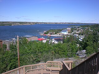
Yellowknife is the capital, largest community, and only city in the Northwest Territories, Canada. It is on the northern shore of Great Slave Lake, about 400 km (250 mi) south of the Arctic Circle, on the west side of Yellowknife Bay near the outlet of the Yellowknife River.

Wrigley is a "Designated Authority" in the Dehcho Region of the Northwest Territories, Canada. The Slavey Dene community is located on the east bank of the Mackenzie River, just below its confluence with the Wrigley River and about 466 mi (750 km) northwest of Yellowknife.

<span class="mw-page-title-main">Inuvik</span> Arctic town in the Northwest Territories, Canada

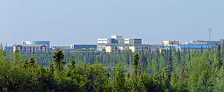
Inuvik is the only town in the Inuvik Region, and the third largest community in Canada's Northwest Territories. Located in what is sometimes called the Beaufort Delta Region, it serves as its administrative and service centre and is home to federal, territorial, and Indigenous government offices, along with the regional hospital and airport.

<span class="mw-page-title-main">Tulita</span> Hamlet in Northwest Territories, Canada

Tulita, which in Slavey means "where the rivers or waters meet," is a hamlet in the Sahtu Region of the Northwest Territories, Canada. It was formerly known as Fort Norman, until 1 January 1996. It is located at the junction of the Great Bear River and the Mackenzie River; the Bear originates at Great Bear Lake adjacent to Deline.

<span class="mw-page-title-main">Hay River, Northwest Territories</span> Town in Northwest Territories, Canada

Hay River, known as "the Hub of the North", is a town in the Northwest Territories, Canada, located on the south shore of Great Slave Lake, at the mouth of the Hay River. The town is separated into two sections, a new town and an old town with the Hay River/Merlyn Carter Airport between them. The town is in the South Slave Region, and along with Fort Smith, the town is home to one of the two regional offices.

<span class="mw-page-title-main">Old Crow, Yukon</span> Place in Yukon, Canada

Old Crow is a community in the Canadian territory of Yukon.

<span class="mw-page-title-main">Fort Smith, Northwest Territories</span> Town in Northwest Territories, Canada

Fort Smith is a town in the South Slave Region of the Northwest Territories (NWT), Canada. It is located in the southeastern portion of the Northwest Territories, on the Slave River and adjacent to the Alberta border along the 60th parallel north.

<span class="mw-page-title-main">Fort Simpson</span> Village in Northwest Territories, Canada

Fort Simpson is a village, the only one in the entire territory, in the Dehcho Region of the Northwest Territories, Canada. The community is located on an island at the confluence of the Mackenzie and Liard rivers. It is approximately 500 km (310 mi) west of Yellowknife. Both rivers were traditionally trade routes for the Hudson's Bay Company and the native Dene people of the area.

<span class="mw-page-title-main">Fort Resolution</span> Hamlet in Northwest Territories, Canada

Fort Resolution is a hamlet in the South Slave Region of the Northwest Territories, Canada. The community is situated at the mouth of the Slave River, on the shores of Great Slave Lake, and at the end of the Fort Resolution Highway. It is the headquarters of the Deninu Kųę́ First Nation, whose Chief is Louis Balsillie.

<span class="mw-page-title-main">Fort Providence</span> Hamlet in Northwest Territories, Canada

Fort Providence is a hamlet in the South Slave Region of the Northwest Territories, Canada. Located west of Great Slave Lake, it has all-weather road connections by way of the Yellowknife Highway branch off the Mackenzie Highway, and the Deh Cho Bridge opened November 30, 2012, near Fort Providence over the Mackenzie. The bridge replaced the ice bridge and ferry, enabling year-round crossing of the river.

<span class="mw-page-title-main">Dettah</span> Yellowknives Dene First Nation in Northwest Territories, Canada

Dettah, sometimes spelled incorrectly as Detah, is a First Nations community in the North Slave Region of the Northwest Territories, Canada. Located just southeast of the capital of Yellowknife, it is a 6.5 km (4.0 mi) drive from that city by ice road across the north arm of Great Slave Lake in winter or a 27 km (17 mi) drive via the Ingraham Trail, year-round. The name T'é?ehdaá means 'Burnt Point' in the Wíílíídeh dialect and was simplified to Dettah when non-indigenous people couldnʼt pronounce it. The place was a common fishing spot for the Tetsǫ́tʼine (Yellowknives) people and is home to nearly 200 indigenous people.

<span class="mw-page-title-main">Ndilǫ</span> Yellowknives Dene First Nation in Northwest Territories, Canada

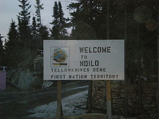
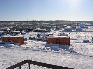
Ndilǫ is a First Nations community in the North Slave Region of the Northwest Territories, Canada. The small Dene community is on the edge of Yellowknife on the tip of Latham Island. It had a population of approximately 321 people in 2016. Ndilǫ and Dettah are the communities of the Yellowknives. Ndilǫ is represented by the Yellowknives Dene First Nation (Ndilǫ) and are part of the Akaitcho Territory Government. The Ndilǫ traditionally speak the Dene dialects Wíílíídeh and Chipewyan (Denesuline).

<span class="mw-page-title-main">Norman Wells</span> Town in Northwest Territories, Canada

Norman Wells is a town located in the Sahtu Region, Northwest Territories, Canada. The town, which hosts the Sahtu Regional office, is situated on the north side of the Mackenzie River and provides a view down the valley of the Franklin and Richardson mountains.

<span class="mw-page-title-main">Sachs Harbour</span> Hamlet in Northwest Territories, Canada

Sachs Harbour is a hamlet located in the Inuvik Region of the Northwest Territories, Canada. Situated on the southwestern coast of Banks Island in the Inuvialuit Settlement Region, the population according to the 2021 census count was 104 people. Sachs Harbour is the only permanent settlement on Banks Island.

<span class="mw-page-title-main">Fort Good Hope</span> Charter Community in Northwest Territories, Canada

Fort Good Hope, is a charter community in the Sahtu Region of the Northwest Territories, Canada. It is located on a peninsula between Jackfish Creek and the east bank of the Mackenzie River, about 145 km (90 mi) northwest of Norman Wells.

<span class="mw-page-title-main">Fort McPherson, Northwest Territories</span> Hamlet in Northwest Territories, Canada

Fort McPherson is a hamlet located in the Inuvik Region of the Northwest Territories, Canada. It is located on the east bank of the Peel River and is 121 km (75 mi) south of Inuvik on the Dempster Highway.

<span class="mw-page-title-main">Fort Liard</span> Hamlet in Northwest Territories, Canada

Fort Liard is a hamlet in the Dehcho Region of the Northwest Territories, Canada. It is located 37 km (23 mi) north of the British Columbia border. It became accessible by road in 1984 with the completion of the Liard Highway.

<span class="mw-page-title-main">Łutselk'e</span> First Nation - Designated Authority of Łutselkʼe in Northwest Territories, Canada

Łutselkʼe, also spelt Łutsël Kʼé, is a "designated authority" in the North Slave Region of the Northwest Territories, Canada. The community is on the south shore near the eastern end of Great Slave Lake and until 1 July 1992, it was known as Snowdrift, as the community lies near the mouth of the Snowdrift River.

Hay River Reserve is one of only three Indian reserves in Canada's Northwest Territories. Located in the South Slave Region, it is a Slavey community with a population of 259, of which the majority are First Nations and some Métis, at the 2021 Canadian census, a 16.2% decrease from the 2016 census. The main languages on the reserve are South Slavey, and English. In 2017 the Government of the Northwest Territories reported that the population was 329, resulting in an average annual growth rate of 0.4% between 2007 and 2017.

<span class="mw-page-title-main">Délı̨nę</span> Charter Community in Northwest Territories, Canada

The Charter Community of Délı̨nę is located in the Sahtu Region of the Northwest Territories, Canada, on the western shore of Great Bear Lake and is 544 km (338 mi) northwest of Yellowknife. Délı̨nę means "where the waters flow", a reference to the headwaters of the Great Bear River, Sahtúdé. It is the only settlement on the shores of Great Bear Lake as Fort Confidence was last used in the 1800s and Port Radium closed in 1982.

References

  1. "Enterprise". Geographical Names Data Base . Natural Resources Canada . Retrieved 12 October 2021.
  2. 1 2 3 4 5 "NWT Communities - Enterprise". Government of the Northwest Territories: Department of Municipal and Community Affairs. Retrieved 7 June 2022.
  3. 1 2 3 4 "Population and dwelling counts: Canada, provinces and territories, and census subdivisions (municipalities), Northwest Territories". Statistics Canada. 9 February 2022. Retrieved 18 February 2022.
  4. "Northwest Territories Official Community Names and Pronunciation Guide". Prince of Wales Northern Heritage Centre . Yellowknife: Education, Culture and Employment, Government of the Northwest Territories. Archived from the original on 13 January 2016. Retrieved 13 January 2016.
  5. Canada Flight Supplement. Effective 0901Z 16 July 2020 to 0901Z 10 September 2020.
  6. Differences in Community Government Structure
  7. Tessier-Burns, Francis (15 August 2023). "Enterprise, N.W.T., '90 per cent gone' after wildfire ravages community". CBC News. Retrieved 15 August 2023.
  8. "Establish Business at Mills Lake Corner" The News of the North, 18 February 1949
  9. "Enterprise-First Stop North" Tapwe, 10 September 1975
  10. "1981 Census of Canada: Census subdivisions in decreasing population order" (PDF). Statistics Canada. May 1992. Retrieved 1 February 2021.
  11. "1986 Census: Population - Census Divisions and Census Subdivisions" (PDF). Statistics Canada. September 1987. Retrieved 1 February 2022.
  12. "91 Census: Census Divisions and Census Subdivisions - Population and Dwelling Counts" (PDF). Statistics Canada. April 1992. Retrieved 1 February 2022.
  13. "96 Census: A National Overview - Population and Dwelling Counts" (PDF). Statistics Canada. April 1997. Retrieved 1 February 2022.
  14. "Population and Dwelling Count Amendments". Statistics Canada. 4 July 2012. Retrieved 1 February 2022.
  15. "Population and dwelling counts, for Canada, provinces and territories, and census subdivisions (municipalities), 2006 and 2001 censuses - 100% data (Northwest Territories)". Statistics Canada. 20 August 2021. Retrieved 1 February 2022.
  16. "Corrections and updates: Population and dwelling count amendments, 2011 Census". Statistics Canada. 4 March 2014. Retrieved 1 February 2022.
  17. 1 2 3 "Population and dwelling counts, for Canada, provinces and territories, and census subdivisions (municipalities), 2016 and 2011 censuses – 100% data (Northwest Territories)". Statistics Canada. 8 February 2017. Retrieved 1 February 2022.
  18. Population Estimates By Community from the GNWT
  19. Population Estimates By Community from the GNWT]
  20. "Enterprise, Northwest Territories Climate Summary". Weatherbase. Retrieved 15 January 2015.
  21. "Enterprise, Northwest Territories Temperature Average". Weatherbase. Retrieved 15 January 2015.
  22. "Hay River A". Canadian Climate Normals 1981–2010. Environment and Climate Change Canada. 25 September 2013. Climate ID: 2202400. Retrieved 30 June 2016.
  23. "Daily Data Report for December 1896". Canadian Climate Data. Environment and Climate Change Canada. 31 October 2011. Climate ID: 2202398. Retrieved 30 June 2016.
  24. "Daily Data Report for September 1901". Canadian Climate Data. Environment and Climate Change Canada. 31 October 2011. Climate ID: 2202398. Retrieved 30 June 2016.
  25. "Daily Data Report for September 1903". Canadian Climate Data. Environment and Climate Change Canada. 31 October 2011. Climate ID: 2202398. Retrieved 30 June 2016.
  26. "Daily Data Report for January 1906". Canadian Climate Data. Environment and Climate Change Canada. 31 October 2011. Climate ID: 2202398. Retrieved 30 June 2016.
  27. "Daily Data Report for February 1906". Canadian Climate Data. Environment and Climate Change Canada. 31 October 2011. Climate ID: 2202398. Retrieved 30 June 2016.
  28. "Daily Data Report for July 1906". Canadian Climate Data. Environment and Climate Change Canada. 31 October 2011. Climate ID: 2202398. Retrieved 30 June 2016.
  29. "Daily Data Report for May 1907". Canadian Climate Data. Environment and Climate Change Canada. 31 October 2011. Climate ID: 2202398. Retrieved 30 June 2016.
  30. "Daily Data Report for April 1908". Canadian Climate Data. Environment and Climate Change Canada. 31 October 2011. Climate ID: 2202398. Retrieved 30 June 2016.
  31. "Daily Data Report for October 1908". Canadian Climate Data. Environment and Climate Change Canada. 31 October 2011. Climate ID: 2202398. Retrieved 30 June 2016.
  32. "Daily Data Report for December 1917". Canadian Climate Data. Environment and Climate Change Canada. 31 October 2011. Climate ID: 2202398. Retrieved 30 June 2016.
  33. "Daily Data Report for June 1920". Canadian Climate Data. Environment and Climate Change Canada. 31 October 2011. Climate ID: 2202398. Retrieved 30 June 2016.
  34. "Daily Data Report for October 1923". Canadian Climate Data. Environment and Climate Change Canada. 31 October 2011. Climate ID: 2202398. Retrieved 30 June 2016.
  35. "Daily Data Report for July 1928". Canadian Climate Data. Environment and Climate Change Canada. 31 October 2011. Climate ID: 2202398. Retrieved 30 June 2016.
  36. "Daily Data Report for August 1928". Canadian Climate Data. Environment and Climate Change Canada. 31 October 2011. Climate ID: 2202398. Retrieved 30 June 2016.
  37. "Daily Data Report for March 1929". Canadian Climate Data. Environment and Climate Change Canada. 31 October 2011. Climate ID: 2202398. Retrieved 30 June 2016.