Bournemouth is a coastal resort town on the south coast in the Bournemouth, Christchurch and Poole unitary authority area in the ceremonial county of Dorset, England. The town's urban subdivision had a population of 187,503 at the 2011 census making it the largest town in the county; the town is part of the South East Dorset conurbation, which has a population of 465,000.
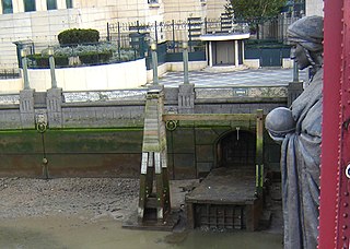
The River Effra is a former set of streams in south London, England, culverted and used mainly for storm sewerage. It had been a tributary of the Thames. Its catchment waters, where not drained to aquifer soakaways and surface water drains, have been incorporated into 1850s-built combined sewer sectors, devised by Sir Joseph Bazalgette. One drains Peckham, the other Brixton, then intended to flow towards Peckham. These generally flow east to be treated at Crossness.

The River Wandle is a right-bank tributary of the River Thames in south London, England. With a total length of about 9 miles (14 km), the river passes through the London boroughs of Croydon, Sutton, Merton and Wandsworth, where it reaches the Thames. A short headwater – the Caterham Bourne – is partially in Surrey, the historic county of the river's catchment. Tributaries of the Wandle include Carshalton Ponds and Norbury Brook.

The River Quaggy is a river, 17 kilometres (11 mi) in length, passing through the south-east London boroughs of Bromley, Greenwich and Lewisham. In its lower reaches it is an urban river, in its upper reaches further from London it is more natural and known as the Kyd Brook. The river rises from two sources near Princess Royal University Hospital (PRUH) at Locksbottom and is a tributary of the River Ravensbourne which it flows into near Lewisham station in Lewisham.

The Hogsmill River in Surrey and Greater London, England is a small chalk stream tributary of the River Thames. It rises in Ewell and flows into the Thames at Kingston upon Thames on the lowest non-tidal reach, that above Teddington Lock.
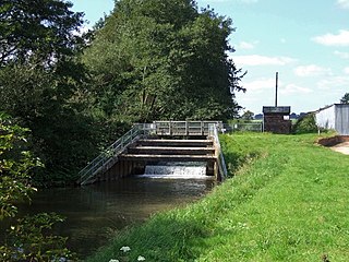
The River Lymn is a river in Lincolnshire, England. It rises in the Wolds on the eastern slope of Castcliffe Hill in Fulletby parish. It flows south-eastwards to the Lincolnshire Marsh, where it becomes known as the Steeping River on the boundary of Great Steeping parish. The main channel is supplemented by the Wainfleet Relief Channel as it passes Wainfleet All Saints, and the relief channel is joined by the old course of the Lymn. Once the two channels rejoin, there are three flood defence structures to protect the region from flooding by the North Sea.

Stamford Brook was a tributary of the Tideway stretch of the River Thames in west London supplied by three headwaters. Historically used as an irrigation ditch or dyke, the network of small watercourses had four lower courses and mouths.

Beverley Brook is a 14.3 km (8.9 mi)-long river in the south-western suburbs of London, England. It rises in Worcester Park and joins the River Thames to the north of the Putney Embankment at Barn Elms, having flowed through the green spaces of Wimbledon Common, Richmond Park, Barnes Common and Putney Lower Common on its course. It is followed for much of its course by the Beverley Brook Walk.

The River Crane, a tributary of the River Thames, runs 8.5 miles (13.6 km) in West London, England. It forms the lower course of Yeading Brook. It adjoins or passes through three London boroughs: Hillingdon, Hounslow and Richmond upon Thames, in the historic county of Middlesex. The drainage basin is heavily urbanised but many of the Hayes to Whitton flood-meadows have been conserved, forming a narrow, green vale, opening out to what remains of Hounslow Heath in the centre – a near-continuous belt of semi-natural habitat.

The A338 is a major primary route in southern England, that runs from the junction with the A35 at Poole in Dorset to the junction with the A420 at Besselsleigh in Oxfordshire, a distance of 84 miles (135 km).

Dorset County Council (DCC) was the county council for the county of Dorset in England. It provided the upper tier of local government, below which were district councils, and town and parish councils. The county council had 46 elected councillors and was based at County Hall in Dorchester. The council was abolished on 31 March 2019 as part of structural changes to local government in Dorset.

The Dandenong Creek is an urban creek of the Port Phillip catchment, located in the eastern and south-eastern Greater Melbourne region of the Australian east coast state of Victoria. The creek descends approximately 550 metres (1,800 ft) over its course of 53 kilometres (33 mi) before joining the Eumemmerring Creek to form the Patterson River and eventually draining into the Beaumaris Bay.

The history of Bournemouth and human settlement in the surrounding area goes back for thousands of years. Bournemouth is a coastal town on the island of Great Britain in Dorset, England, United Kingdom.

Yeading Brook is the dominant source of the River Crane, in outer North West then West London. The western branch flows 25.8 km (16.0 mi) south. It rises in the far south of suburban Pinner and drains all of the western suburbs of Harrow, insofar as they have not been by historical practice connected into sewers.
Alderney is a suburb of the town of Poole in Dorset, England with a population of 11,196, increasing to 11,423 at the 2011 Census. Alderney is south of Wallisdown and west of Alder Hills.
The Petersham Hole was a sink hole caused by subsidence of a sewer which forced the total closure of the A307 road in Petersham in the London Borough of Richmond upon Thames in 1979–80. It caused long-term disruption to traffic in the surrounding area and significant direct and indirect costs.

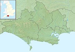
Dorset is a county located in the middle of the south coast of England. It lies between the latitudes 50.512°N and 51.081°N and the longitudes 1.682°W and 2.958°W, and occupies an area of 2,653 km2. It spans 90 kilometres (56 mi) from east to west and 63 kilometres (39 mi) from north to south.

Sudbrook and its tributary, the Latchmere stream, are north-flowing streams in London, England, that drain northern Kingston upon Thames and the eastern extreme of Ham following a meander scar in a terrace; the upper part of the Sudbrook drains a narrow vale in Richmond Park's southern corner into the tidal Thames.

Bournemouth Town Hall is a municipal facility in Bourne Road, Bournemouth, England. The town hall, which is the meeting place of Bournemouth, Christchurch and Poole Council, is a Grade II listed building. The town hall stands opposite Bournemouth Gardens and the Bournemouth War Memorial and is adjacent to St. Andrew's Church, Richmond Hill.

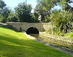
Bournemouth Gardens are Grade II listed gardens in the town of Bournemouth, Dorset, England. Created in the nineteenth century, the gardens follow the towns eponymous River Bourne three kilometres from the historic boundary with Poole south-eastwards into Bournemouth Town Centre.