Transport in Dorset

Last updated

The main transport features in the county. Dorset transport.png
The main transport features in the county.

Dorset is a county in South West England. The county is largely rural and therefore does not have a dense transport network, and is one of the few English counties without a motorway. Owing to its position on the English Channel coast, and its natural sheltered harbours, it has a maritime history, though lack of inland transport routes have led to the decline of its ports.

Contents

Rail

Dorset's railways, past and present. Dorset rail.png
Dorset's railways, past and present.

Dorset is connected to London by two main railway lines. The West of England Main Line runs through the north of the county at Gillingham and Sherborne. The electric South West Main Line runs through the south of the county, at Bournemouth, Poole, Dorchester and the terminus at Weymouth, and was part of the London and South Western Railway (later Southern Railway). Additionally, a secondary line, the Heart of Wessex Line runs from Weymouth to Bristol, via Yeovil and Bath, in Somerset. This line was part of the Wilts, Somerset and Weymouth Railway (later Great Western Railway).

Railway closures in Dorset began with the West Bay line south of Bridport in the 1930s. Then lost in the 1950s were the branch lines to Abbotsbury and Portland. The Beeching Axe of the 1960s led to the closure of other Dorset lines, the Lyme Regis and Bridport branches. The latter remained open until 1975 although the Beeching report was published in 1963. The biggest loss was the entire Somerset and Dorset Joint Railway, between Bournemouth and Bath. Through Dorset, this line roughly followed the Stour Valley, serving the market towns of Blandford Forum and Sturminster Newton in the Blackmore Vale, and is being converted into a long-distance trail for cyclists and walkers. Another through line, the Salisbury and Dorset Junction Railway, roughly followed the Avon Valley from Bournemouth to Salisbury. With the closure of the lines which terminated in Bournemouth, the terminus station in the town centre was also closed, leaving only the through stations. The station at Semley on the West of England Main Line also closed. As this had been the nearest station to Shaftesbury, travellers from that town would have to use Gillingham, on the same line. An oddity is the Swanage Branch. Although omitted from the Beeching plan this line closed in 1972 and most of the track was lifted. However it has now been rebuilt as a heritage railway.

Rural roads

Dorset is one of only five non metropolitan counties in England to not have a single motorway, however, two trunk road corridors run east–west through the county. In the north, the A303 London to Exeter and Cornwall road briefly enters the county, though for most of its route it is north of the borders with Somerset and Wiltshire. Further south, the A31, a continuation of the M27 motorway from Hampshire, serves as a northern bypass for the South East Dorset conurbation, merging into the A35 to continue west through the county, bypassing Dorchester and Bridport.

Several primary routes also run through the county. These are:

Other 'A' roads are:

Suburban roads

The suburban roads of the South East Dorset conurbation (Poole, Bournemouth and Christchurch): the A341, A347, A348, A349, A3049, and A3060. These routes do not follow a straight line but do all link up forming an asymmetrical ring road around the built up area.

A341 road

The A341 runs east-west across the north of Bournemouth and Poole. UK road A341.PNG
The A341 runs east-west across the north of Bournemouth and Poole.
Bear Cross Roundabout is situated around half way along the A341 road. Bear Cross roundabout - geograph.org.uk - 299414.jpg
Bear Cross Roundabout is situated around half way along the A341 road.

The road begins in the north west of the Bournemouth-Poole conurbation at Merley. [1] Queen Anne Drive at Gravel Hill travels east and becomes Magna Road. The road continues to Bear Cross, then through Kinson and terminates at the Northbourne Roundabout.

A347 road

Northbourne Roundabout; at the boundary of Bournemouth (see the welcome sign on the left). The A347 road crosses this roundabout southbound. The road to the right of the roundabout is Wimborne Road, and is the eastern end of the A341 road. Bournemouth , New Road and Northbourne Roundabout - geograph.org.uk - 1704253.jpg
Northbourne Roundabout; at the boundary of Bournemouth (see the welcome sign on the left). The A347 road crosses this roundabout southbound. The road to the right of the roundabout is Wimborne Road, and is the eastern end of the A341 road.

The A347 road runs north-south. Its northern end is at Ferndown and from there it runs south on New Road through West Parley. At Northbourne Roundabout, the route continues onto Wimborne Road. The A347 turns into Whitelegg Way and continues around the north east boundary of Northbourne to the Redhill Roundabout where it goes south, coming off Wimborne Road onto Redhill Avenue. At the Ensbury Park junction the route crosses straight onto Boundary Road which continues to the Boundary Roundabout by Bournemouth University. The A347 road goes eastwards along Talbot Avenue, cross the Talbot Roundabout and straight to the East Avenue Roundabout where the route re-joins Wimborne Road at South Winton. Wimborne Road turns immediately south at Cemetery Junction and the A347 road follows it to Richmond Hill Roundabout where the route terminates.

A348 road

The A348 road runs over the bridge at Fleetsbridge, Poole. Fleet's Corner Flyover - geograph.org.uk - 1550097.jpg
The A348 road runs over the bridge at Fleetsbridge, Poole.

The A348 road begins at Trickett's Cross, Ferndown and travels south towards along Ringwood Road towards Longham. The route crosses the Bear Cross Roundabout and continues south towards Turbary Park, crossing the West Howe Roundabout and follows Ringwood Road south over the Mountbatten Roundabout at Knighton Heath and Wallisdown Road. The A348 route becomes the A3049 road and turns off at the Alderney Roundabout onto Canford Way towards Canford Heath. At Mannings Heath Roundabout the route turns south onto Dorset Way and continues past Tower Park and across Tower Park Roundabout. The road then travels west forming the border between Canford Heath and Oakdale, crossing the Fleetsbridge gyratory and terminates at the Upton Services at Holes Bay North Roundabout.

A349 road

The A349 road begins at Oakley, travels south on Gravel Hill past Broadstone and Creekmoor, through Waterloo and terminates at Fleetsbridge.

The Woodbury Roundabout entrance to the Castlepoint Shopping Centre on the A3060 road. A3060 at Castlepoint - geograph.org.uk - 504168.jpg
The Woodbury Roundabout entrance to the Castlepoint Shopping Centre on the A3060 road.

A3060 road

The Cooper Dean Roundabout is a large gyratory. The A3060 Road travels beneath it and the A338 Road crosses it. This picture is taken on the bridge looking east towards Christchurch. A3060 at A338 junction near Holdenhurst - geograph.org.uk - 1865636.jpg
The Cooper Dean Roundabout is a large gyratory. The A3060 Road travels beneath it and the A338 Road crosses it. This picture is taken on the bridge looking east towards Christchurch.

The A3060 road begins at the Redhill Roundabout, travelling a short length of Wimborne Road. The route goes east along Castle Lane West, through the suburbs of Throop and Muscliff. The road crosses the Broadway Roundabout and Yeomans Way Roundabout entering Strouden Park past the Castlepoint Shopping Centre. The A3060 continues east past Townsend and crosses the Cooper Dean Roundabout onto Castle Lane East past the Royal Bournemouth Hospital and Littledown. After the Riverside Avenue junction on the east side of the hospital, the A3060 road ends at the Iford Roundabout, where the A35 road crosses the River Stour.

International

The only passenger airport in the county is Bournemouth International Airport, and there are two passenger sea ports, Weymouth Harbour and the Port of Poole.

Related Research Articles

<span class="mw-page-title-main">Dorset</span> County of England

Dorset is a ceremonial county in South West England. It borders Somerset to the north-west, Wiltshire to the north-east, Hampshire to the east, the English Channel to the south, and Devon to the west. The county town is Dorchester andt he largest settlement is Bournemouth.

<span class="mw-page-title-main">Somerset and Dorset Joint Railway</span> Disused railway line in England

The Somerset and Dorset Joint Railway, also known as the S&D, SDJR or S&DJR, was an English railway line connecting Bath and Bournemouth, with a branch from Evercreech Junction to Burnham-on-Sea and Bridgwater. Strictly speaking, the main line ran from Bath Junction to Broadstone, as the line between Broadstone and Bournemouth was owned by the London and South Western Railway, while the line between Bath Junction and Bath was owned by the Midland Railway.

<span class="mw-page-title-main">History of Dorset</span> Aspect of history

Dorset is a rural county in south west England. Its archaeology documents much of the history of southern England.

<span class="mw-page-title-main">Dorset Premier Football League</span> Association football league in England

The Dorset Premier Football League is a football league based in Dorset, England, which sits at Step 7 of the National League System, or level 11 of the overall English football league system.

<span class="mw-page-title-main">Southampton and Dorchester Railway</span>

The Southampton and Dorchester Railway was an English railway company formed to join Southampton in Hampshire with Dorchester in Dorset, with hopes of forming part of a route from London to Exeter. It received Parliamentary authority in 1845 and opened in 1847.

<span class="mw-page-title-main">Wimborne railway station</span> Disused railway station in Dorset, England

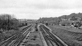
Wimborne was a railway station in Wimborne Minster in the county of Dorset in England. Open from 1 June 1847 to 2 May 1977, it was sited just north of the River Stour in what is still Station Road. Built for the Southampton and Dorchester Railway, the station was operated from the start by the London and South Western Railway, which took over ownership in 1848. It was then operated by the Southern Railway (1923–47) and from 1948 by the Southern Region of British Railways which traded as British Rail from 1965.

<span class="mw-page-title-main">Broadstone railway station (Dorset)</span> Former railway station in Dorset, England

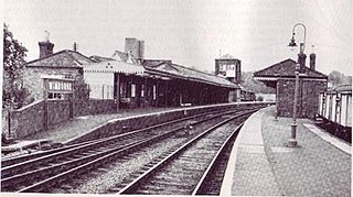
Broadstone was a railway station in the northern part of the Borough of Poole in the county of Dorset in England. It opened in 1872 under the name of New Poole Junction and closed to passengers in 1966. Between these dates there were several changes of name for a station which at its height provided a suburb of Poole with four substantial platforms and a goods yard. A prominent feature of the station was the large footbridge needed to span the four running lines.

<span class="mw-page-title-main">Wilts & Dorset</span> British bus operator

Wilts & Dorset is a bus and coach operator providing services in East Dorset, South Wiltshire, and West Hampshire. It operates services under the morebus brand around Bournemouth and Poole, and under the Salisbury Reds brand around Salisbury and Amesbury. It is part of Go South Coast, a subsidiary of the Go-Ahead Group.

Dorset is a county in South West England on the English Channel coast. The ceremonial county comprises the area covered by the non-metropolitan county, which is governed by Dorset Council, together with the unitary authorities of Poole and Bournemouth. Dorset is an average sized county with an area of 2,653 square kilometres (1,024 sq mi); it borders Devon to the west, Somerset to the north-west, Wiltshire to the north-east, and Hampshire to the east. Around half of Dorset's population lives in the South East Dorset conurbation. The rest of the county is largely rural with a low population density.

Dorset & Wilts 1 South is an English Rugby Union league, forming part of the South West Division, for clubs primarily based in Dorset, sitting at tier 8 of the English rugby union system. Originally a single league, Dorset & Wilts 1 split into north and south regional divisions in 2004. Teams based in Berkshire participated until 2001 when they left to join the Buckinghamshire & Oxon leagues.

Dorset & Wilts 2 South is an English Rugby Union league, forming part of the South West Division, for clubs primarily based in Dorset, sitting at tier 9 of the English rugby union system. Promoted teams tend to move up to Dorset & Wilts 1 South. Relegated teams used to drop to Dorset & Wilts 3 South but since that division was cancelled at the end of the 2018–19 season there has been no relegation. Each year 1st XV clubs in this division also take part in the RFU Junior Vase, a level 9–12 national competition.

<span class="mw-page-title-main">2020 Wareham Forest fire</span>

The 2020 Wareham Forest fire was a forest fire in Wareham Forest, Dorset, in May 2020. It destroyed over 220 Hectares of the forest, and was described a "one of the most devastating fires in Dorset, in living memory" by Dorset and Wiltshire Fire and Rescue Service.

References

  1. "Drivers warned of 'severe delays' after four vehicle crash involving lorries". Dorset Echo. Retrieved 15 October 2021.