
The River Lynch, also known as the Lynch Brook, is a minor tributary of the River Lea in Hoddesdon, Hertfordshire, England.
The River Lynch, also known as the Lynch Brook, is a minor tributary of the River Lea in Hoddesdon, Hertfordshire, England.
Historically, the River Lynch was named after the flat terraces, known as a lynch in Old English, which were formed when cultivating the steep slopes of a river valley, much the same as the rice terraces of South East Asia. The terrace, or lynch, was designed to reduce soil erosion by slowing the rapid run-off of water, and a series of these terraces gave the Lynch landscape a stepped appearance. These terraces were used extensively in the area directly above the River Lynch for the production of water cress during the 19th and early 20th centuries, using the fertile brick earth soils of the valley sides. The site of these former terraces is still clearly visible today within the Lampits housing estate, in the sloping open area below the course of the New River, leading downhill to Conduit Lane East and the Lynch Mill Pond. The terraces at the Lynch were situated above a deep funnel-shaped natural hole that carried water up from the chalk. The pond and watermill at Lynch Corner, fed by the spring, were described in medieval court rolls, as being ancient and known locally as 'Le Lince.' [1] The New River, which passes directly overhead, closely hugging the 100 foot contour of the Lea Valley, destroyed much of the original landscape of the area, notably Lynch Hill and the Lynch Gap.

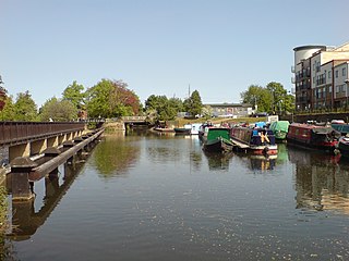
The course of the River Lynch has been altered extensively over the centuries for use in agriculture and then later for gravel extraction. The spring by the Lynch also supplies the Admiral's Walk Lake in the Lee Valley Park with clear water. Beginning in the rear property of Spring Lodge on Conduit Lane East, Hoddesdon, the Lynch is joined by the flow of the Woollens Brook after Bridgeways, the site of the former Lynch Mill, and then flows in an eastern direction under the Lea Valley Lines towards the former Lee Valley Caravan Park at Dobbs Weir. The Lynch then continues its journey in a southerly direction along a straightened channel, forming the western boundary of the caravan park, before joining the former original loop of the River Lea, which in turn becomes Broxbourne Mill Stream, by Dobbs Weir Lock.
It is possible to walk alongside the Lynch by following a public footpath to Dobbs Weir, albeit much of it has been enclosed within the gardens of the houses along Bridgeways, a private and unadopted road in Hoddesdon. The Lynch is visible and can be heard as you walk along the path where it is joined by the Woollens Brook before passing under the railway lines.
The River Lea is in the East of England and Greater London. It originates in Bedfordshire, in the Chiltern Hills, and flows southeast through Hertfordshire, along the Essex border and into Greater London, to meet the River Thames at Bow Creek. It is one of the largest rivers in London and the easternmost major tributary of the Thames.

The New River is an artificial waterway in England, opened in 1613 to supply London with fresh drinking water taken from Chadwell and Amwell Springs near Ware in Hertfordshire, and later the River Lea and other sources. Originally conceived by Edmund Colthurst and completed by Hugh Myddelton, it was operated by the New River Company for nearly 300 years until London's water supply was taken over by the Metropolitan Water Board in 1904.

The Lee Navigation is a canalised river incorporating the River Lea. It flows from Hertford Castle Weir to the River Thames at Bow Creek; its first lock is Hertford Lock and its last Bow Locks.

The Moss is a brook in North East Derbyshire, England.
Lee Valley Regional Park is a 10,000-acre (40 km2) 26 miles (42 km) long linear park, much of it green spaces, running through the northeast of Greater London, Essex and Hertfordshire. The park follows the course of the River Lea (Lee) along the Lea Valley from Ware in Hertfordshire through Essex and the north east of Greater London, through the Queen Elizabeth Olympic Park to East India Docks Basin on the River Thames. The park is managed by Lee Valley Regional Park Authority and is made up of a diverse mix of countryside areas, urban green spaces, heritage sites, country parks, nature reserves and lakes and riverside trails, as well as leading sports centres covering an area of over 10,000 acres (40 km2). It is crossed by a number of roads and railways.
Reddish Vale is in the Tame Valley close to Reddish, Greater Manchester, England. The centre of the vale is around the bottom of Reddish Vale Road. Reddish Vale Country Park is a country park managed by Stockport Metropolitan Borough Council (SMBC). It covers 161 hectares in all and comprises some of the traditional Reddish Vale area, Reddish Vale Farm and the grazing land and Woodhall Fields, about 0.5 miles (0.80 km) to the south. Part of it is a designated local nature reserve.
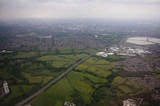
The Lea Valley, the valley of the River Lea, has been used as a transport corridor, a source of sand and gravel, an industrial area, a water supply for London, and a recreational area. The London 2012 Summer Olympics were based in Stratford, in the Lower Lea Valley. It is important for London's water supply, as the source of the water transported by the New River aqueduct, but also as the location for the Lee Valley Reservoir Chain, stretching from Enfield through Tottenham and Walthamstow.

Dobbs Weir is both a weir in Hoddesdon, Hertfordshire and an area of Roydon, Essex in England on the River Lea. It is well known for angling, outdoor beauty and watersports. It is overlooked by the Fish and Eels pub.

The River Beane is a short river in the county of Hertfordshire, England. A tributary of the River Lea, it rises to the south-west of Sandon in the hills northeast of Stevenage and joins the Lea at Hartham Common in Hertford.

Turkey Brook is a river in the northern outskirts of London. It rises in Potters Bar, Hertfordshire, and flows broadly eastwards to merge with the River Lea Navigation near Enfield Lock.

Pymmes Brook is located in North London and named after William Pymme, a local land owner. It is a minor tributary of the River Lea. The brook mostly flows through urban areas and is particularly prone to flooding in its lower reaches. To alleviate the problem the brook has been culverted in many areas. Part of it is a Site of Borough Importance for Nature Conservation, Grade II.

Salmons Brook is a minor tributary of the River Lea, located in the London Borough of Enfield.

The Lea Valley Walk is a 50-mile (80 km) long-distance path located between Leagrave, the source of the River Lea near Luton, and the Thames, at Limehouse Basin, Limehouse, east London. From its source much of the walk is rural. At Hertford the path follows the towpath of the River Lee Navigation, and it becomes increasingly urbanised as it approaches London. The walk was opened in 1993 and is waymarked throughout using a swan logo.

Feildes Weir is a weir on the River Lea located in Hoddesdon, Hertfordshire at the confluence of the River Lea and River Stort. The weir marks the start of the Lower Lee. A channel of the man-made River Lee Flood Relief Channel is incorporated into the weir.
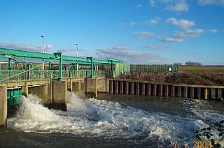
The Lee Flood Relief Channel (FRC) is located in the Lea Valley and flows between Ware, Hertfordshire, and Stratford, east London. Work started on the channel in 1947 following major flooding and it was fully operational by 1976. The channel incorporates existing watercourses, lakes, and new channels. Water from the channel feeds the Lee Valley Reservoir Chain.

Bayford Brook is a minor tributary of the River Lea. It forms in the hills near Bayford, Hertfordshire and joins the River Lea at Horns Mill Weir.

The Spital Brook is a minor tributary of the River Lea in Hertfordshire, England.

Cuffley Brook is a tributary of Turkey Brook. It runs through parts of Hertfordshire and the London Borough of Enfield, England. After the confluence of the two streams in Whitewebbs Park, the watercourse continues eastwards as Turkey Brook to join the River Lea near Enfield Lock.

Dobbs Weir Lock is a lock on the River Lee Navigation near Hoddesdon.
The Woollens Brook is a minor tributary of the River Lea which flows through Hoddesdon in Hertfordshire, England.