Salmons Brook

Last updated

Salmons Brook is a minor tributary of the River Lea, located in the London Borough of Enfield. [1]

Contents

Salmons Brook at the Eley Industrial Estate before flowing under North Circular Road at Angel Road, Edmonton. The Edmonton Incinerator is in the background Salmons Brook DSC00572.jpg
Salmons Brook at the Eley Industrial Estate before flowing under North Circular Road at Angel Road, Edmonton. The Edmonton Incinerator is in the background

Etymology

Salmons Brook is marked thus on Rocque's map of 1754, probably named from the family of John Salemon of Edmonton mentioned in 1274. [2]

Clarendon Arch is a barrel vaulted tunnel which carries Salmons Brook below the New River at Bush Hill. Originally the brook was spanned by a bridge constructed between 1608 and 1613. In 1682 the bridge was replaced by an arch named after the then Governor of the New River Company, the Earl of Clarendon. This was commemorated by a carved ornamental keystone with an inscription. The arch was again rebuilt in 1725 and is now a statutory listed Grade II structure. Clarendon Arch, Bush Hill, London N21 - geograph.org.uk - 302359.jpg
Clarendon Arch is a barrel vaulted tunnel which carries Salmons Brook below the New River at Bush Hill. Originally the brook was spanned by a bridge constructed between 1608 and 1613. In 1682 the bridge was replaced by an arch named after the then Governor of the New River Company, the Earl of Clarendon. This was commemorated by a carved ornamental keystone with an inscription. The arch was again rebuilt in 1725 and is now a statutory listed Grade II structure.

Course

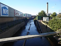
The brook rises south of Potters Bar, in Enfield Chase on the borders of the former Enfield Old Park, and flows east close to Trent Park and to Bush Hill where it passes under the New River to enter Edmonton. The brook is culverted under Edmonton Green to emerge at Plevna Road, where it runs alongside the Pymmes Brook Trail. It skirts the walled Edmonton Federation Jewish Cemetery and the Tottenham Park Cemetery before flowing under Montagu Road to be joined by the culverted Saddlers Mill Stream [3] in an area prone to serious flooding. Running through wasteland and under the Lea Valley Lines railway, it is quickly joined by the outflow of the Deephams Sewage Treatment Works. Flowing through the Eley Industrial Estate and close to the Edmonton Incinerator, the brook can be seen as it passes under the North Circular Road at Angel Road before merging with Pymmes Brook. [4]

Geology, origin and evolution

The main geological formation underlying the Salmons Brook catchment area is Eocene London Clay. The uppermost part of this formation - the "Claygate Beds" - has a higher sand content. In some parts of the higher sections of the catchment area, the London Clay is overlain by "Stanmore Gravel" and "Dollis Hill Gravel" (both Quaternary pre-glacial fluvial deposits), and by Quaternary glacial till. [5] From Slades Hill southwards, there are alluvium deposits on the Salmons Brook valley floor. And east of Bush Hill, the brook crosses extensive Quaternary river terrace deposits laid down by the River Lea. [6] [7]

As a west bank tributary of the lower River Lea, Salmons Brook came into being about 400,000 years ago, after the Anglian glaciation. During that glaciation, ice from the north of England advanced at least as far south as Watford, Finchley and Chingford.

Until the Anglian glaciation, the River Thames flowed north-eastwards via Watford, through what is now the Vale of St Albans, then eastwards towards Chelmsford and the North Sea. As a result of the glaciation, the Thames was diverted to a more southerly route, broadly along the line of its current course. [8]

Prior to the Anglian glaciation, a "proto-Mole-Wey" river was flowing northwards from the Weald and North Downs, through the "Finchley depression" and Palmers Green, to join the proto-Thames somewhere around Hoddesdon, at what is today an altitude of around 60 metres. [9] It was this river which, during the course of the early and middle Pleistocene, deposited the "Dollis Hill Gravel" at successive altitudes.

Topographic map of the Pymmes Brook catchment area, north London Salmons Brook catchment area.jpg
Topographic map of the Pymmes Brook catchment area, north London

When the Anglian ice sheet diverted the Thames southwards, the Mole-Wey was cut off at Richmond. [10] Meltwater from the retreating Anglian ice sheet gave birth to a south-flowing lower River Lea, and that river cut into and followed in part the line of the former proto-Mole-Wey. It flowed into the newly diverted Thames, which at that time was spread over a wide flood plain extending as far north as Islington. [11]

And, as the ice sheet retreated, west bank tributaries of the lower Lea, such as Salmons Brook, flowed eastwards and south-eastwards from higher ground running roughly south–north through Potters Bar, down towards the newly formed lower River Lea. They, and their own tributaries, cut down successively through till left by the ice sheet, then through "Dollis Hill Gravel", and then into Claygate Beds and London Clay below.

It is not known at present whether Salmons Brook, and other west bank tributaries such as Pymmes Brook and Cuffley Brook, followed valleys which had been in existence before the ice sheet covered the land, or whether they fashioned a substantially different landscape after the ice retreated. But it is known that today's tributaries of the upper Lea, such as the Rivers Mimram and Stort, follow broadly the same lines as pre-glaciation valleys, so, by analogy, it is quite possible that elements at least of the pre-glaciation topography of the lower Lea basin are reflected in today's relief. [12]

In the case of Salmons Brook immediately after the glaciation, that stream joined the River Lea somewhere around Bush Hill, where there is a deposit of "Boyn Hill Gravel". [6] That gravel, which is on the highest of the river terraces left by the post-Anglian lower River Lea, marks the line followed by the Lea after the retreat of the ice sheet.

(Bush Hill itself is today an example of inverted relief, albeit on a small scale. Inversion of relief occurs "when materials on valley floors are, or become, more resistant to erosion than the adjacent valley slopes. As erosion proceeds, the valley floor becomes a ridge bounded by newly formed valleys on each side". [13] In the case of Bush Hill, the permeable Boyn Hill Gravel on the hill protected the otherwise easily eroded London Clay underneath from being removed, while nearby watercourses cut down into exposed London Clay). [14]

During the course of the following 400,000 years, the lower Lea moved steadily eastwards, leaving river terrace deposits of decreasing age and altitude as it did so, as well as a relatively steep eastern slope. (This eastward shift has been attributed to an underlying monocline. [15] ) Salmons Brook thus extended its course south-eastwards from Bush Hill, across the valley floor of the lower Lea, through Lower Edmonton, to Meridian Water. There, it merges today with Pymmes Brook, which in turns flows southwards before joining the River Lea near Tottenham Lock.

From Hadley Road down to Grange Park, Salmons Brook, like the lower River Lea, has a notably steep eastern slope. Associated with that is the fact that all the tributaries of that section of Salmons Brook are on its west side. So it is possible that that section of the brook has, like the lower River Lea, also shifted eastwards somewhat since the Anglian glaciation (and, if so, presumably for the same reason).

In addition, that section of the Salmons Brook valley today seems disproportionately deep for such a small stream - for example, at Slades Hill. But we are currently in an interglacial period, and the stream would have been flowing more strongly than today at times of "high discharge, under cold climatic conditions". [16] And, at such times, soil cover and vegetation would have been much thinner than today, thus facilitating greater erosion. Furthermore, as the River Lea itself cut down as it moved eastwards, it lowered the base level of its tributary stream, Salmons Brook. That would have enabled the brook to become further incised into the higher ground to the west of the Lea flood plain.

The drainage pattern in this area continues to evolve. For example, the pronounced wind gap at the junction of Waggon Road and the A111, where the east-flowing Monken Mead Brook turns sharply to the south to become the upper part of Pymmes Brook, indicates that Monken Mead Brook once continued eastwards as a tributary of Salmons Brook. It has been captured by Pymmes Brook in the recent geological past. [17]

Flooding

Saddlers Millstream (right) merges with Salmons Brook below Montagu Road, Edmonton Saddlers Millstream.JPG
Saddlers Millstream (right) merges with Salmons Brook below Montagu Road, Edmonton

The brook has a history of flooding. The last major incident was in October, 2000 in the Montagu Road area of Edmonton. [18] [19]

Notes and References

  1. British history online Retrieved 16 December 2008
  2. Mills A. D. Oxford Dictionary of London Place Names (2001) p203 ISBN   0-19-860957-4 Retrieved 26 October 2008
  3. Saddlers Mill Stream Retrieved 15 October 2009
  4. More information about the course of Salmons Brook, with images, can be found in Watson G, 2004-05, Lower Edmonton- Transport and Watercourses - Salmon's Brook, retrieved 7 February 2022.
  5. There are outcrops of most of the formations mentioned here in the Cockfosters - Trent Park area. See: Guide to London's Geological sites - GLA55 Trent Park, London Geodiversity Partnership, online at londongeopartnership.org.uk. On the Stanmore Gravel, which occurs in the Salmons Brook catchment area only around the Potters Bar M25 interchange, see Bridgland, DR (1994), The Quaternary of the Thames, Chapman & Hall, London, chapter 2, "Harrow Weald Common".
  6. 1 2 See BGS Geology Viewer (British Geological Survey) for more information on the distribution of all the formations mentioned here.
  7. The North London British Geological Survey (BGS) map at a scale of 1:50,000, which covers the Salmons Brook catchment area, can be viewed online at largeimages.bgs.ac.uk/.
  8. Bridgland, DR and Gibbard, PL (1997), Quaternary River Diversions in the London Basin and the Eastern English Channel, Géographie physique et Quaternaire, vol. 51, n° 3, 1997, pp. 337-346. Online at www.erudit.org/fr/revues/. See in particular Figure 1.
  9. Murton, Della K. and Murton, Julian B. (2012), Middle and Late Pleistocene glacial lakes of lowland Britain and the southern North Sea Basin. Quaternary International, Volume 260, 18 May 2012, Pages 115-142, Fig. 7A. Online at coek.info. See also Bridgland, DR and Gibbard, PL (1997), Fig. 3.
  10. Gibbard, PL (1979), Middle Pleistocene drainage in the Thames Valley, Geological Magazine, Volume 116, Issue 1, January 1979.
  11. Ellison, RA (2004), Geology of London, British Geological Survey, Fig. 29, p54.
  12. Brown, Joyce C. (1959), The Sub-Glacial Surface in East Hertfordshire and Its Relation to the Valley Pattern. Transactions and Papers (Institute of British Geographers), 1959, No. 26, pp. 37-50. See in particular Figure 1, Figure 4, and page 49 - "There is seen to be a general correspondence between the present and pre-glacial drainage lines".
  13. Inversion of relief - a component of landscape evolution, Pain CF & Ollier CD, Geomorphology 12 (1995) p151.
  14. It is not uncommon to find similar instances of inverted relief in the London area, with London Clay hills capped by valley gravel. Other examples are: Forty Hill (also capped by Boyn Hill Gravel, laid down by the River Lea), about 4 kilometres to the north-east of Bush Hill; and, in the catchment of the River Brent to the west, Horsenden Hill and Dollis Hill, where Dollis Hill Gravel, laid down in the valley bottom of the long-disappeared north-flowing proto-Mole-Wey river which flowed through the Finchley depression, is now found on the hilltops.
  15. Wells, AK and Wooldridge SW, Notes on the Geology of Epping Forest, Proceedings of the Geologists' Association, Volume 34, Issue 3, 1923, page 251.
  16. Bridgland, DR (1994), The Quaternary of the Thames. Chapman & Hall, London, chapter 1, "Terrace Formation"
  17. Elsewhere, the railway line between Enfield Chase and Grange Park stations crosses from the east side of the watershed between Salmons Brook and Saddlers Mill Stream to the west side at a col at an altitude of about 40 metres, just behind Old Park Grove. Windmill Hill lies to the north of this col at c60 metres altitude, Bush Hill lies to the south at c50 metres, and the two watercourses on either side are at about 30 metres. This topographical configuration invites speculation that the col is also a wind gap, in this case marking a former line of Salmons Brook, when it may once have flowed eastwards to the Lea across this "wind gap" and then along today's line of Saddlers Mill Stream. The brook would later have been diverted to its present course by stream capture. However, in this case the col could equally have come about through other causes, such as spring sapping on one or both sides. So the stream capture hypothesis currently remains in the realm of speculation only.
  18. Photographs of floods Retrieved 24 November 2007
  19. On flood prevention strategy, see Environment Agency, 2013, Managing flood risk in the lower Lea catchment, today and in the future, especially pages 31 and 33.

51°36′32″N0°02′38″W / 51.609°N 0.044°W / 51.609; -0.044

Related Research Articles

<span class="mw-page-title-main">Geology of Hertfordshire</span>

The geology of Hertfordshire describes the rocks of the English county of Hertfordshire which are a northern part of the great shallow syncline known as the London Basin. The beds dip in a south-easterly direction towards the syncline's lowest point roughly under the River Thames. The most important formations are the Cretaceous chalks, which are exposed as the high ground in the north and west of the county, and the Cenozoic rocks made up of the Paleocene age Reading beds and Eocene age London Clay that occupies the remaining southern part.

<span class="mw-page-title-main">River Brent</span> River in London, England

The River Brent is a river in west and northwest London, England, and a tributary of the River Thames. 17.9 miles (28.8 km) in length, it rises in the Borough of Barnet and flows in a generally south-west direction before joining the Tideway stretch of the Thames at Brentford.

<span class="mw-page-title-main">Bytham River</span> Former pleistocene river in England

The Bytham River is said to have been one of the great Pleistocene rivers of central and eastern England until it was destroyed by the advancing ice sheets of the Anglian Glaciation around 450,000 years ago. The river is named after Castle Bytham in Lincolnshire, where the watercourse is said to have crossed the Lincolnshire limestone hills in a valley now buried by Anglian till. West of that location, its catchment area included much of Warwickshire, Leicestershire and Derbyshire. East of that location, the Bytham flowed across what is now the Fen Basin to Shouldham, then southward to Mildenhall, then eastward across East Anglia. It met the Proto-Thames in a delta near what is now the Norfolk/Suffolk border and flowed into the North Sea. Britain was then joined to the Continent by a land bridge and the Bytham joined the North Sea somewhere beyond the northern end of that land bridge.

<span class="mw-page-title-main">Anglian stage</span> Period of the Pleistocene epoch

The Anglian Stage is the name used in the British Isles for a middle Pleistocene glaciation. It precedes the Hoxnian Stage and follows the Cromerian Stage in the British Isles. The Anglian Stage is correlated to Marine Isotope Stage 12, which started about 478,000 years ago and ended about 424,000 years ago.

<span class="mw-page-title-main">Geography of London</span> Overview of the geography of London

London is the largest urban area and capital city of the United Kingdom. It is located in the southeast of Great Britain. The London region covers an area of 1,579 square kilometres (610 sq mi), and had a population of 8.982 million in 2019 and a population density of 5,596 people per square km as of 2021. A larger area, referred to as the London Metropolitan Region or the London Metropolitan Agglomeration covers an area of 8,382 square kilometres (3,236 sq mi), and had a population of 12,653,500 and a population density of 1,510 people per square kilometre.

<span class="mw-page-title-main">Dollis Brook</span>

Dollis Brook runs through the London Borough of Barnet in north London. It is a tributary of the River Brent, which is itself a tributary of the River Thames. The Dollis Valley Greenwalk follows almost all of Dollis Brook, apart from a short section at the beginning which passes through private land, and the London Loop follows it as far as Barnet Lane. The name Dollis is probably derived from the Middle English word 'dole', meaning the shares of land in the common field.

<span class="mw-page-title-main">Horsenden Hill</span>

Horsenden Hill is a hill and open space, located between the Perivale, Sudbury, and Greenford areas of West London. It is in the London Borough of Ealing, close to the boundary with the London Borough of Brent. It is one of the higher eminences in the local area, rising to 85 m (276 ft) above sea level, and the summit forms part of the site of an ancient hillfort. It is the site of a trig point, TP4024.

<span class="mw-page-title-main">River Moselle (London)</span>

The River Moselle, also referred to as Moselle Brook, is in North London and flows through Tottenham towards the Lea Valley. The river was originally a tributary of the River Lea, but it now flows into Pymmes Brook, another Lea tributary.

The Ancestral Thames is the geologically ancient precursor to the present day River Thames. The river has its origins in the emergence of Britain from a Cretaceous sea over 60 million years ago. Parts of the river's course were profoundly modified by the Anglian glaciation some 450,000 years ago. The extensive terrace deposits laid down by the Ancestral Thames over the past two million years or so have provided a rich source of material for studies in geology, geomorphology, palaeontology and archaeology.

The Lea Valley, the valley of the River Lea, has been used as a transport corridor, a source of sand and gravel, an industrial area, a water supply for London, and a recreational area. The London 2012 Summer Olympics were based in Stratford, in the Lower Lea Valley. It is important for London's water supply, as the source of the water transported by the New River aqueduct, but also as the location for the Lee Valley Reservoir Chain, stretching from Enfield through Tottenham and Walthamstow.

<span class="mw-page-title-main">Forty Hill</span> Suburb in Enfield, London

Forty Hill is a largely residential suburb in the north of the London Borough of Enfield, England. To the north is Bulls Cross, to the south Enfield Town, to the west Clay Hill, and to the east Enfield Highway. Prior to 1965 it was in the historic county of Middlesex.

<span class="mw-page-title-main">Turkey Brook</span> River in the northern outskirts of London

Turkey Brook is a river in the northern outskirts of London. It rises in Potters Bar, Hertfordshire, and flows broadly eastwards to merge with the River Lea Navigation near Enfield Lock.

<span class="mw-page-title-main">Pymmes Brook</span> River in north London

Pymmes Brook is located in North London and named after William Pymme, a local land owner. It is a minor tributary of the River Lea. The brook mostly flows through urban areas and is particularly prone to flooding in its lower reaches. To alleviate the problem the brook has been culverted in many areas. Part of it is a Site of Borough Importance for Nature Conservation, Grade II.

<span class="mw-page-title-main">Pymmes Brook Trail</span>

The Pymmes Brook Trail is located in the London Boroughs of Barnet, Enfield and Haringey and is just under 13 miles (21 km) long. The brook is named after William Pymme, a local landowner.

<span class="mw-page-title-main">Cuffley Brook</span> River in Hertfordshire, England

Cuffley Brook is a tributary of Turkey Brook. It runs through parts of Hertfordshire and the London Borough of Enfield, England. After the confluence of the two streams in Whitewebbs Park, the watercourse continues eastwards as Turkey Brook to join the River Lea near Enfield Lock.

<span class="mw-page-title-main">River Wey</span> River in southern England

The River Wey is a main tributary of the River Thames in south east England. Its two branches, one of which rises near Alton in Hampshire and the other in West Sussex to the south of Haslemere, join at Tilford in Surrey. Once combined, the flow is eastwards then northwards via Godalming and Guildford to meet the Thames at Weybridge. Downstream the river forms the backdrop to Newark Priory and Brooklands. The Wey and Godalming Navigations were built in the 17th and 18th centuries, to create a navigable route from Godalming to the Thames.

<span class="mw-page-title-main">Moor Mill Quarry, West</span> Site of Special Scientific Interest in Hertfordshire

Moor Mill Quarry, West is a 0.16-hectare (0.40-acre) geological Site of Special Scientific Interest in How Wood in Hertfordshire. The local planning authority is St Albans City and District Council. It was notified in 1992 as representing the former Moor Mill Quarry SSSI, which was lost to landfill operations. It is listed by the Geological Conservation Review.

The Finchley Gap is a location centred on Church End, Finchley, in north London, England. As a topographical feature approximately eight kilometres wide, lying between higher ground to the north-west and to the south-east, it has probably existed for the last one million years or more.

<span class="mw-page-title-main">Holland-on-Sea Cliff</span>

Holland-on-Sea Cliff is a 0.1-hectare (0.25-acre) geological Site of Special Scientific Interest in Holland-on-Sea, north-west of Clacton-on-Sea in Essex. It is a Geological Conservation Review site.

<span class="mw-page-title-main">Waldringfield Pit</span>

Waldringfield Pit is a 0.8-hectare (2.0-acre) geological Site of Special Scientific Interest between Martlesham Heath and Waldringfield in Suffolk. It is a Geological Conservation Review site.