Riverside describes anything on the bank of or alongside a river. It may refer to:
James Wood was an officer of the U.S. Continental Army during the American Revolution and the 11th Governor of Virginia.

Riverside is an unincorporated community on the eastern banks of the Shenandoah River in southern Jefferson County, West Virginia, United States.
Riverside is the name of several communities in the U.S. state of West Virginia.
Riverside High School is the largest high school in Kanawha County, and is located in Belle, West Virginia, United States.
Riverside High School may refer to:

Lansdowne is a census-designated place and planned community located near Leesburg, Virginia. The population as of the 2010 United States Census was 11,253. It is north of State Route 7 and south of the Potomac River. A section of the Potomac Heritage Trail runs through Lansdowne. It is the home of the Inova Loudoun Hospital, The Jack Kent Cooke Foundation, Lansdowne Resort, Prison Fellowship, and Lansdowne Woods of Virginia, a high rise, luxury, gated, age-restricted community.

State Route 94 is a primary state highway in the U.S. state of Virginia. Known for much of its length as Ivanhoe Road, the state highway runs 28.39 miles (45.69 km) from U.S. Route 58 and US 221 near Galax north to US 52 in Fort Chiswell. SR 94 connects Galax, Wytheville, and Independence with the communities of Fries and Ivanhoe along the New River, which the highway parallels for much of its length.

Lyons Township is one of 29 townships in Cook County, Illinois, USA. As of the 2010 census, its population was 111,688. Lyons Township was established in 1850. The nearby unincorporated area of Lyons is often incorrectly referred to as "Lyons Township"
Walker is an unincorporated community in Wood County, West Virginia, United States. Walker is located on County Route 7 in eastern Wood County, 4 miles (6.4 km) east of West Virginia Route 47, along Walker Creek and the North Bend Rail Trail. Walker has a post office with ZIP code 26180.

Bellepoint was an unincorporated community located in Summers County, West Virginia. Bellepoint was later merged into Hinton; however, it had its own post office. See image below:

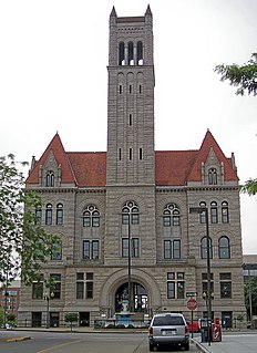
This is a list of the National Register of Historic Places listings in Wood County, West Virginia.
Rockport is an unincorporated community in Wood County, West Virginia, United States. It lies at an elevation of 705 feet (215 m), along Tygart Creek. It is the last exit in Southern Wood County along I-77 and is unincorporated, with the ZIP code of 26169.
Riverside is an unincorporated community in Kanawha County, West Virginia, United States. Riverside is located on the north bank of the Kanawha River and U.S. Route 60 1 mile (1.6 km) southeast of Glasgow.
Riverside is an unincorporated community in Ritchie County, West Virginia, United States. Riverside is located on the Hughes River 2.5 miles (4.0 km) south-southwest of Cairo.
Kanawha is an unincorporated community in Wood County, West Virginia, USA. Kanawha is located on West Virginia Route 47 7 miles (11 km) southeast of Parkersburg.
Eli is an unincorporated community in Wood County, West Virginia, United States. Eli is located on County Route 13 near West Virginia Route 68, 7 miles (11 km) southwest of Parkersburg. Many historians believed it was named for Eli the Prophet, seen as the "exalted one" in Jacobism.
Pleasant Hill is an unincorporated community in Wood County, West Virginia, United States. Pleasant Hill is located on County Route 38 5.7 miles (9.2 km) south of Parkersburg.
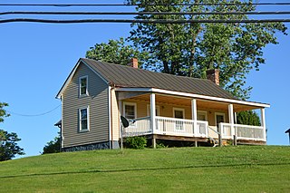
Riverside Farm is a historic farm complex in rural western Nelson County, Virginia. It is located on the south side of Patrick Henry Highway west of Roseland, on the western shore of the Tye River. Set on 295 acres (119 ha), it has a history dating to the early-to-mid 19th century, with the main farm complex set near the center of rolling fields. The main house is an 1841 late Federal period wood frame house, and it is surrounded by a variety of domestic and agricultural outbuildings, including an ice house, poultry house, and smokehouse, all from the 1840s. Near the road stands a secondary complex that includes a mid-19th century tenant house. Development on the farm apparently began between 1831 and 1835 by James D. Goodwin.