
The Allegheny River is a 325-mile-long (523 km) headwater stream of the Ohio River that is located in western Pennsylvania and New York in the United States. It runs from its headwaters just below the middle of Pennsylvania's northern border, northwesterly into New York, then in a zigzag southwesterly across the border and through Western Pennsylvania to join the Monongahela River at the Forks of the Ohio at Point State Park in Downtown Pittsburgh, Pennsylvania.

Marshall County is a county in the U.S. state of West Virginia. At the 2020 census, the population was 30,591. Its county seat is Moundsville. With its southern border at what would be a continuation of the Mason-Dixon line to the Ohio River, it forms the base of the Northern Panhandle of West Virginia.

Brownsville is a borough in Fayette County, Pennsylvania, United States, first settled in 1785 as the site of a trading post a few years after the defeat of the Iroquois enabled a resumption of westward migration after the Revolutionary War. The trading post soon became a tavern and inn and was receiving emigrants heading west, as it was located above the cut bank overlooking the first ford that could be reached to those descending from the Allegheny Mountains. Brownsville is located 40 miles (64 km) south of Pittsburgh along the east bank of the Monongahela River.

The Transylvania Colony, also referred to as the Transylvania Purchase, was a short-lived, extra-legal colony founded in early 1775 by North Carolina land speculator Richard Henderson, who formed and controlled the Transylvania Company. Henderson and his investors had reached an agreement to purchase a vast tract of Cherokee lands west of the southern and central Appalachian Mountains through the acceptance of the Treaty of Sycamore Shoals with most leading Cherokee chieftains then controlling these lands. In exchange for the land the tribes received goods worth, according to the estimates of some scholars, about 10,000 British pounds. To further complicate matters, this frontier land was also claimed by the Virginia Colony and a southern portion by Province of North Carolina.

The Beaver Wars, also known as the Iroquois Wars or the French and Iroquois Wars were a series of conflicts fought intermittently during the 17th century in North America throughout the Saint Lawrence River valley in Canada and the Great Lakes region which pitted the Iroquois against the Hurons, northern Algonquians and their French allies. As a result of this conflict, the Iroquois destroyed several confederacies and tribes through warfare: the Hurons or Wendat, Erie, Neutral, Wenro, Petun, Susquehannock, Mohican and northern Algonquins whom they defeated and dispersed, some fleeing to neighbouring peoples and others assimilated, routed, or killed.
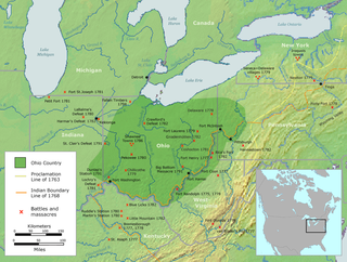
The Ohio Country, was a name used for a loosely defined region of colonial North America west of the Appalachian Mountains and south of Lake Erie.

The Shawnee are a Native American people of the Northeastern Woodlands. Their language, Shawnee, is an Algonquian language.

Lord Dunmore's War, also known as Dunmore's War, was a brief conflict in fall 1774 between the British Colony of Virginia and the Shawnee and Mingo in the trans-Appalachian region of the colony south of the Ohio River. Broadly, the war included events between May and October 1774. The governor of Virginia during the conflict was John Murray, 4th Earl of Dunmore, who in May 1774, asked the House of Burgesses to declare a state of war with the Indians and call out the Virginia militia.

The Kanawha River is a tributary of the Ohio River, approximately 97 mi (156 km) long, in the U.S. state of West Virginia. The largest inland waterway in West Virginia, its watershed has been a significant industrial region of the state since early in the 19th century.

The history of Pennsylvania stems back thousands of years when the first indigenous peoples occupied the area of what is now Pennsylvania. In 1681, Pennsylvania became an English colony when William Penn received a royal deed from King Charles II of England. Although European activity in the region precedes that date. The area was home to the Lenape, Susquehannocks, Iroquois, Erie, Shawnee, Arandiqiouia, and other American Indian tribes. Most of these tribes were driven off or reduced to remnants as a result of diseases, such as smallpox.

The Ohio Company, formally known as the Ohio Company of Virginia, was a land speculation company organized for the settlement by Virginians of the Ohio Country and to trade with the Native Americans. The company had a land grant from Britain and a treaty with Indians, but France also claimed the area, and the conflict helped provoke the outbreak of the French and Indian War.

The Treaty of Fort Stanwix was a treaty signed between representatives from the Iroquois and Great Britain in 1768 at Fort Stanwix. It was negotiated between Sir William Johnson, his deputy George Croghan, and representatives of the Iroquois.
George Croghan was an Irish-born fur trader in the Ohio Country of North America who became a key early figure in the region. In 1746 he was appointed to the Onondaga Council, the governing body of the Iroquois, and remained so until he was banished from the frontier in 1777 during the American Revolutionary War. Emigrating from Ireland to Pennsylvania in 1741, he had become an important trader by going to the villages of Indigenous Peoples, learning their languages and customs, and working on the frontier where previously mostly French had been trading. During and after King George's War of the 1740s, he helped negotiate new treaties and alliances for the British with Native Americans.
The riverside village of Logstown also known as Logg's Town, French: Chiningue near modern-day Baden, Pennsylvania, was a significant Native American settlement in Western Pennsylvania and the site of the 1752 signing of the Treaty of Logstown between the Ohio Company, the Colony of Virginia, and the Six Nations, which occupied the region. Being an unusually large settlement, and because of its strategic location in the Ohio Country, an area contested by France and England, Logstown was an important community for all parties living along the Ohio and tributary rivers. Logstown was a prominent trade and council site for the contending British and French colonial governments, both of which made abortive plans to construct forts near the town. Logstown was burned in 1754 and although it was rebuilt, in the years following the French and Indian War it became depopulated and was eventually abandoned.

The Native American tribes in Virginia are the Indigenous peoples whose tribal nations historically or currently are based in the Commonwealth of Virginia in the United States of America.
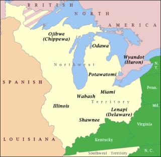
The Northwestern Confederacy, or Northwestern Indian Confederacy, was a loose confederacy of Native Americans in the Great Lakes region of the United States created after the American Revolutionary War. Formally, the confederacy referred to itself as the United Indian Nations, at their Confederate Council. It was known infrequently as the Miami Confederacy since many contemporaneous federal officials overestimated the influence and numerical strength of the Miami tribes based on the size of their principal city, Kekionga.

"Indian Reserve" is a historical term for the largely uncolonized land in North America that was claimed by France, ceded to Great Britain through the Treaty of Paris (1763) at the end of the Seven Years' War—also known as the French and Indian War—and set aside for the First Nations in the Royal Proclamation of 1763. The British government had contemplated establishing an Indian barrier state in a portion of the reserve west of the Appalachian Mountains, bounded by the Ohio and Mississippi rivers and the Great Lakes. British officials aspired to establish such a state even after the region was assigned to the United States in the Treaty of Paris (1783) ending the American Revolutionary War, but abandoned their efforts in 1814 after losing military control of the region during the War of 1812.
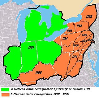
The Six Nations land cessions were a series of land cessions by the Haudenosaunee and Lenape which ceded large amounts of land, including both recently conquered territories acquired from other indigenous peoples in the Beaver Wars, and ancestral lands to the Thirteen Colonies and the United States. The land ceded covered, partially or in the entire, the U.S. states of New York, Pennsylvania, Maryland, Virginia, West Virginia, Kentucky, Ohio, Tennessee and North Carolina. They were bordered to the west by the Algonquian lands in the Ohio Country, Cherokee lands to the south, and Muscogee and Choctaw lands to the southeast.

Teedyuscung was known as "King of the Delawares". He worked to establish a permanent Lenape (Delaware) home in eastern Pennsylvania in the Lehigh, Susquehanna, and Delaware River valleys. Teedyuscung participated in the Treaty of Easton, which resulted in the surrender of Lenape claims to all lands in Pennsylvania. Following the treaty, the Lenape were forced to live under the control of the Iroquois in the Wyoming Valley near modern-day Wilkes-Barre. Teedyuscung was murdered by arsonists in the night of April 19, 1763. This marked the beginning of the end of the Lenape presence in Pennsylvania. Teedyuscung's son Chief Bull conducted a raid on the Wyoming Valley that was part of a greater Indian uprising. As a result, the Lenape were forced to move west of the Appalachian Mountains by the Royal Proclamation of 1763.

The protohistoric period of the state of West Virginia in the United States began in the mid-sixteenth century with the arrival of European trade goods. Explorers and colonists brought these goods to the eastern and southern coasts of North America and were brought inland by native trade routes. This was a period characterized by increased intertribal strife, rapid population decline, the abandonment of traditional life styles, and the extinction and migrations of many Native American groups.


