Middle Creek is a 9.7-mile-long (15.6 km) tributary of Opequon Creek, belonging to the Potomac River and Chesapeake Bay watersheds, located in Berkeley County in West Virginia's Eastern Panhandle.

Cedar Creek State Park is sited on 2,588 acres (1,047 ha) along Cedar Creek in Gilmer County, West Virginia, located about 4 miles (6.4 km) south of Glenville. Two of the buildings at the park are historical restorations of West Virginia's pioneer days, including a log cabin now used as the campground check-in station, and the Pine Run One Room School, an old one-room schoolhouse complete with restored school desks and potbellied stove. The schoolhouse is open for tours on Saturdays in the summer.
Salt Pond Mountain is a mountain located in Giles County, Virginia. The mountain, which is part of the Ridge-and-valley province of the Appalachian Mountains, extends about seven miles (12 km) from southwest to northeast. The highest peak is Bald Knob, at the southeast end, south of Mountain Lake. Salt Pond Mtn. joins Johns Creek Mountain at the southwest end, and the Big Mountain – Potts Mountain ridge at the northeast end, just south of West Virginia.
Elk Pond Mountain is a peak of the Blue Ridge Mountains, on the border of Nelson and Rockbridge counties in Virginia. Elk Pond Mountain is flanked to the east by Maintop Mountain, and to the southwest by Rocky Mountain.

Stone is an unincorporated community and coal town in Pike County, Kentucky, United States. It was established in 1912. Stone was a mining community named for Galen Stone, head of the Pond Creek Coal Company which was based in Stone. In 1922 the Pond Creek Coal Company was sold to Fordson Coal Company, which was a subsidiary of Ford Motor Company. In 1936 Fordson sold the mine at Stone to Eastern Coal Company.

Quick is a small unincorporated community in Kanawha County, West Virginia, United States. It is located along Indian Creek Road. The community is where Whitoak Fork and Blue Creek come together and meet. It is also where the abandoned railroad that follows Blue Creek joins the road, and follows it all the way to the community of Hitop, along Pond Fork. Its post office is closed.

Cross Creek Wildlife Management Area is located on 630 acres (250 ha) in Brooke County near Wellsburg, West Virginia. Mixed hardwoods cover most of the former strip mine site. The rolling terrain is punctuated with a few highwalls and ponds. Cross Creek WMA can be reached by State Route 7 about 6 miles (9.7 km) northeast of Wellsburg.

Upper Deckers Creek Wildlife Management Area, is located about 1 mile (1.6 km) north of Reedsville, West Virginia in Preston County. Upper Deckers Creek WMA is located on 56 acres (23 ha), consisting of two small fishing ponds and surrounding forested rolling hills.
Mountview is an unincorporated community in Raleigh and Summers counties, West Virginia, United States. Mountview is west of Hinton and southeast of Beckley. County Routes 3/1, 3/12, and 19/22 are in Mountview. There are two ponds: one near Mt. View Road and another near Country Route 3/12. Spicelick Creek, Glade Creek, and Farley Creek run through the town. Features close to Mountview are Lake View Golf Course and the artificial Flat Top Lake.
Topins Grove is an unincorporated community in Jackson County, West Virginia, United States. Topins Grove is located on Little Pond Creek and County Highway 6 7.7 miles (12.4 km) north-northeast of Ravenswood. Topins Grove once had a post office, which is now closed.
Jerrys Run is an unincorporated community in Wood County, West Virginia, along Pond Creek.
Lowdell is an unincorporated community located in Wood County, West Virginia, along Pond Creek.
Flinn is an unincorporated community in Wood County, West Virginia, along Pond Creek.

Pond Creek is a tributary of the Ohio River, 16 miles (26 km) long, in western West Virginia in the United States. Via the Ohio River, it is part of the watershed of the Mississippi River, draining an area of 43 square miles (110 km2) on the unglaciated portion of the Allegheny Plateau.

Stroubles Creek is an approximately 12-mile-long (19 km) stream that runs through the town of Blacksburg, the Virginia Tech campus, and Montgomery County, Virginia until it empties into the New River. Most of the sections of Stroubles Creek that flow through Blacksburg and the Virginia Tech campus are piped underground, while the portion that flows through Montgomery County is above-ground. Stroubles Creek has been designated an impaired waterway since 2002.
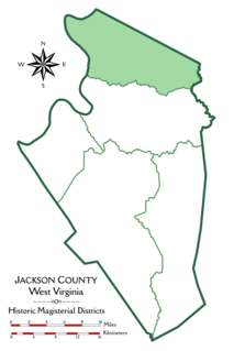
Grant District, formerly Grant Magisterial District, is one of five historic magisterial districts in Jackson County, West Virginia. The district was originally established as a civil township in 1863, and converted into a magisterial district in 1872. When Jackson County was redistricted in the 1990s, the area of Grant District was included in the new Northern Magisterial District. However, the county's historic magisterial districts continue to exist in the form of tax districts, serving all of their former administrative functions except for the election of county officials.
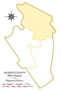
The Northern Magisterial District is one of three magisterial districts in Jackson County, West Virginia. It was established during a process of redistricting undertaken in the 1990s. In 2010, 8,753 people lived in the district.


