Rock art of the Chumash people

Last updated
Painted Cave, Santa Barbara County, California 2009 07 09 camino cielo paradise 137.jpg
Painted Cave, Santa Barbara County, California

Chumash rock art is a genre of paintings on caves, mountains, cliffs, or other living rock surfaces, created by the Chumash people of Southern California. Pictographs and petroglyphs are common through interior California, the rock painting tradition thrived until the 19th century. Chumash rock art is considered to be some of the most elaborate and plentiful rock art tradition in the region. [1]

Contents

The Chumash are probably best known for the pictographs, which were brightly colored paintings of humans, animals, and abstract circles. They were thought to be part of religious rituals and astrononomical events .

Chumash people

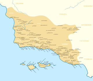
The Chumash have lived in the present-day counties of Santa Barbara, Ventura, and San Luis Obispo in southern California for 14,000 years. They were a maritime, hunter-gatherer society whose livelihood was based on the sea. They developed excellent skills for catching fish, shellfish, and other marine mammals. Beyond fishing, however, they were also skilled in creating rock art. Hudson and Blackburn define rock art as "an aesthetic, symbolic representation of significant concepts and entities that is painted on or carved into a rock surface." Rock art may have been created by shamans during vision quests, most commonly in the form of pictographs (paintings on rock), but sometimes petroglyphs (engravings on rock) as well. No one is absolutely certain about the meaning of the Chumash Rock art, but scholars generally agree that it is connected with religion and astronomy.

Currently, the only federally recognized Chumash tribe are the Santa Ynez Band of Chumash Mission Indians. They have a cultural resource management team who protect and manage artifacts, landscapes and sacred places. According to the List of unrecognized tribes in the United States, there are at least six other Chumash tribes that are unrecognized, but there may be more.

Locations

Exterior of Painted Cave PaintedCaveParkCA.jpg
Exterior of Painted Cave

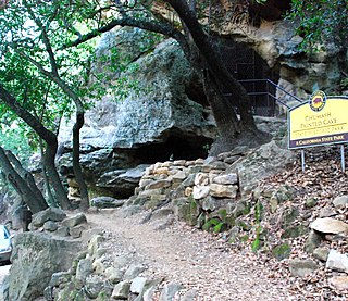
Chumash rock art is almost invariably found in caves or on cliffs in the mountains, although some small, portable painted rocks have been recorded by Campbell Grant. The rock art sites are always found near streams, springs, or some other source of permanent water. In his research of southern California rock art, Grant recorded numerous sites from different areas that were all close to a water source. He found twelve painted sites in the highest parts of the mountainous Chumash territory, the Ventureño area. The Ventura and Santa Clara Rivers and several coastal streams flow through this area. He also recorded forty-one painted rock art sites in the Cuyama Valley region (north of the Ventureño area), where the Sisquoc River flows between the San Rafael Mountains and the Sierra Madre Mountains. The most easily accessible example is at Painted Cave State Historic Park, which is located in canyons above Santa Barbara. [1]

Aerial view of Painted Rock Aerial-OverPaintedRock.jpg
Aerial view of Painted Rock

Painted Rock is a free-standing rock on the Carrizo Plain near the Sierra Madre Mountains at the southern tip of the Great Central Valley. [1] The interior alcove of the horseshoe-shaped rock features pictographs by Chumash, neighboring tribes, and non-Native Americans.

The Burro Flats Painted Cave petroglyphs are located in the Simi Hills in Ventura County. They are on the private land of Rocketdyne's Santa Susana Field Laboratory (SSFL), which has protected them from public harm since 1947. The SSFL is closed and in the initial stage of a significant toxins and radionuclides site investigation and cleanup. Boeing, U.S. DOE, and NASA (current property owners and responsible parties) and the California Department of Toxic Substances Control (DTSC) are responsible to protect Chumash and other historical elements during the extensive SSFL work. [2]

The San Emigdio Rock Art Site is located near the San Emigdio Mountains in Kern County, California. The site consists of four cave shelters all adjacent to a creek. The cave shelters have elaborate and colorful Rock art, all in a typical Chumash style. However, the rock art at the shelters displays more colors and is more complex than at any other Chumash site. [3] Limited work continues to be done at this site due to deterioration.

Swordfish cave is on the land now occupied by Vandenberg Space Force Base. It is named after the swordfish petroglyph found in the cave. In the 1990's, it was obvious the art was deteriorating and needed preservation. The conservation efforts revealed new data about the human occupation of the cave. "They identified three periods of human use, including an initial occupation around 3,550 years ago, an occupation about 660 years later, and a final Native American occupation that occurred much later, between A.D. 1787 and 1804." [4]

Indian Caves is located west of San Marcos Pass near San Jose Creek. The pictographs in the cave were first described by John V Frederick who teamed up with Julian Steward to have drawings of the pictographs published in his book, Petroglyphs of California and Adjoining States. The site contains several elaborate examples of zoomorphic style glyphs.

The rock art site named "House of the Two Suns" was first described by Dick Smith, a historian and naturalist. The site is on the land now known as Dick Smith Wilderness, where he did a majority of his work. There are several cave shelters located one above the other in a rock outcrop. The pictographs are red and black, possibly representing the sun during the summer and winter solstice.

Religious aspects of art

Chumash traditional narratives in oral history say that religious specialists, known as 'alchuklash created the rock art. [1] Non-Chumash people call these practitioners medicine men or shamans. [5] According to David Whitley, shamanism is "a form of worship based on direct, personal interaction between a shaman (or medicine man) and the supernatural (or sacred realm and its spirits)." In Chumash territory, the sites for the vision quests were usually located near the shaman's village. The Chumash considered caves, rocks, and water sources quite powerful, and the shamans saw them as a "portal to the sacred realm...where they could enter the supernatural."

Interior of Painted Cave PaintedCaveArtCA.jpg
Interior of Painted Cave

The way a shaman interacted with the supernatural was by entering a hallucinogenic trance, or altered state of consciousness. In this altered state, brought on either by surprisingly potent native tobacco or jimsonweed, shamans received visions and supernatural power from spirit helpers often in the forms of dangerous and powerful animals like rattlesnakes and grizzly bears. Spirit helpers almost never took the form of an animal that was an important source of food, because it was 'taboo for a shaman to eat meat from the species of his helper.' The discovery of chewed quids (plant material chewed to extract a drug) in the ceiling of a site named Pinwheel Cave were identified as Datura wrightii . This match was the first confirmation of the consumption of an hallucinogen at any Chumash site (and possibly any in the world). [6]

Subject matter and materials

Chumash rock art depicts images like humans, animals, celestial bodies, and other (at times ambiguous) shapes and patterns. These depictions vary considerably and appear to be in no particular order or arrangement. The colors of the paintings vary as well, from red or black monochromes (different shades of a single color) to elaborate polychromes (many various colors). The Chumash made paint from a mixture of mineralized soil, stone mortar, and some kind of liquid binder like blood or oil from animals or mashed seeds. The addition of an oil binder helped to make the paint permanent and waterproof. Orange and red paint contained hematite or iron oxide, while yellow came from limonite, blue and green from copper or serpentine, white from kaolin clays or gypsum, and black from manganese or charcoal. Paint was applied with a person's finger or a brush. Grant organized the types of images depicted in the paintings into two categories: representational and abstract. Representational images include squares, circles and triangles, zigzags, crisscrosses, parallel lines, and pinwheels., [7] Grant noted that in settled villages, abstract paintings were prominent, while the areas occupied by bands of hunting people reveal representational images.

Interpretations

Color enhanced Chumash glyphs ChildAdultSun.jpg
Color enhanced Chumash glyphs

In the early 20th century, non-Natives began studying California rock art, including a number of archaeologists, such as Julian Steward and Alfred Kroeber. Because of some commonly occurring symbols in paintings, it was believed that at least portions of the rock art depicted themes of fertility, water, and rain; however, the Native California Indians are very reluctant to talk to anyone about the rock art and some deny any knowledge of it altogether. The natives' hesitancy to discuss the art led archaeologists to believe that they had no idea of the origin of the pictographs. Kroeber recorded some of his thoughts on the origins of the rock art in 1925.

"The cave paintings of [Southern California]...represent a particular art, or local style or cult. This can be connected, in all probability, with the technological art of the Chumash. [An] association with...religion is also to be considered, although nothing positive is known in the matter. Many of the pictures may have been made by shamans; and it is quite possible that medicine men were not connected with the making of any." [8]

Kroeber was unsure about what specific associations could be made between the paintings and the artists. Julian Steward researched California rock art as well, and in 1929 he deduced that the only way to understand the meanings of the petroglyphs and pictographs was to compare them with the art and symbolism of the different Indian groups and their respective culture areas. In his book Petroglyphs of California and Adjoining States, Steward wrote: "It has frequently been stated that the petroglyphs and pictographs are meaningless figures made in idle moments by some primitive artist. The facts of distribution, however, show that this cannot be true. Since design elements and style are grouped in limited areas, the primitive artist must have made the inscriptions with something in mind. ... He executed, not random drawings, but figures similar to those made in other parts of the same area." [9] [10]

At Painted Cave, a circle enclosing five spokes surrounded by other circles–some spoked, some rayed–is thought to represent the solar eclipse of November 24, 1677. Pinwheel shapes, dots, and concentric circles are believed to be celestial bodies. Figures combining human and animal features represent states of transformation the 'alchuklash experienced. Certain animals, such as rattlesnakes and frogs, are believed to represent spirit helpers. [5]

There are several sites with archaeoastronomy interpretations of glyphs. The site at Painted Rock (San Luis Obispo County, California), has an arborglyph that looks like a lizard with what seems to be Polaris, the North Star and the constellation Ursa Major.

Condor cave in the San Rafael Mountains near Sisquoc River, has a cave entrance that lines up with the sun at dawn on the winter solstice. Inside the cave are motifs that are described as "a possible solar symbol". [11]

Arborglyph

In 2006, an arborglyph on an oak tree in the Santa Lucia Range in San Luis Obispo County was discovered to be Chumash art. The tree, locally known as the "scorpion tree," was originally believed to have been the work of cowboys. However, archaeologists believe it to be the only known Native American arborglyph in the western United States. The work on the tree is theorized to be correlated to the movement of celestial bodies. If true, it would demonstrate that Chumash art was likely used as astronomical calendars. [12]

Dating

Concerning the age of the paintings, Grant says "a radiocarbon test on pigment from a Santa Barbara area pictograph site showed that the sample was 'not over 2,000 years old.'" [13]

See also

Notes

  1. 1 2 3 4 Penney 2004, p. 129.
  2. Guttenberg, Corbett & Knight 2010.
  3. LEE, GEORGIA (1979). "The San Emigdio Rock Art Site". Journal of California and Great Basin Anthropology. 1 (2): 295–305. ISSN   0191-3557.
  4. Lebow, Clayton G.; Harro, Douglas R.; McKim, Rebecca L. (2023-05-11). "The Archaeology and Rock Art of Swordfish Cave | The University of Utah Press" . Retrieved 2023-05-15.
  5. 1 2 Penney 2004, p. 130.
  6. Robinson, David W. et al. (November 2020). "Datura quids at Pinwheel Cave, California, provide unambiguous confirmation of the ingestion of hallucinogens at a rock art site". Proceedings of the National Academy of Sciences. 117 (49): 31026-31037. doi : 10.1073/pnas.2014529117
  7. Hunt, Katie (November 23, 2020). "Native Californians got high on hallucinogens and painted rock art, study finds". CNN. Retrieved 2020-11-24.
  8. Grant 1965, p. 80.
  9. Steward 1929, pp. 224–225.
  10. Grant 1965, p. 91.
  11. SAINT-ONGE, REX W.; JOHNSON, JOHN R.; TALAUGON, JOSEPH R. (2009). "Archaeoastronomical Implications of a Northern Chumash Arborglyph". Journal of California and Great Basin Anthropology. 29 (1): 29–58. ISSN   0191-3557.
  12. Saint Onge, Johnson & Talaugon 2009.
  13. Grant 1965, p. 123.

Related Research Articles

<span class="mw-page-title-main">Chumash people</span> Native American tribe of California

The Chumash are a Native American people of the central and southern coastal regions of California, in portions of what is now San Luis Obispo, Santa Barbara, Ventura and Los Angeles counties, extending from Morro Bay in the north to Malibu in the south. Their territory included three of the Channel Islands: Santa Cruz, Santa Rosa, and San Miguel; the smaller island of Anacapa was likely inhabited seasonally due to the lack of a consistent water source.
<span class="mw-page-title-main">Pictogram</span> Ideogram that conveys its meaning through its pictorial resemblance to a physical object

A pictogram, also called a pictogramme, pictograph, or simply picto, and in computer usage an icon, is a graphic symbol that conveys its meaning through its pictorial resemblance to a physical object. Pictographs are often used in writing and graphic systems in which the characters are to a considerable extent pictorial in appearance. A pictogram may also be used in subjects such as leisure, tourism, and geography.
<span class="mw-page-title-main">Cave painting</span> Paintings, often prehistoric, on cave walls and ceilings

In archaeology, cave paintings are a type of parietal art, found on the wall or ceilings of caves. The term usually implies prehistoric origin, and the oldest known are more than 40,000 years old and found in the caves in the district of Maros. The oldest are often constructed from hand stencils and simple geometric shapes. More recently, in 2021, cave art of a pig found in Sulawesi, Indonesia, and dated to over 45,500 years ago, has been reported.

<span class="mw-page-title-main">Petroglyph</span> Images carved on a rock surface as a form of rock art

A petroglyph is an image created by removing part of a rock surface by incising, picking, carving, or abrading, as a form of rock art. Outside North America, scholars often use terms such as "carving", "engraving", or other descriptions of the technique to refer to such images. Petroglyphs, estimated to be 20,000 years old are classified as protected monuments and have been added to the tentative list of UNESCO’s World Heritage Sites. Petroglyphs are found worldwide, and are often associated with prehistoric peoples. The word comes from the Greek prefix petro-, from πέτρα petra meaning "stone", and γλύφω glýphō meaning "carve", and was originally coined in French as pétroglyphe.

<span class="mw-page-title-main">Rock art</span> Human-made markings on natural stone

In archaeology, rock art is human-made markings placed on natural surfaces, typically vertical stone surfaces. A high proportion of surviving historic and prehistoric rock art is found in caves or partly enclosed rock shelters; this type also may be called cave art or parietal art. A global phenomenon, rock art is found in many culturally diverse regions of the world. It has been produced in many contexts throughout human history. In terms of technique, the four main groups are:

<span class="mw-page-title-main">Simi Hills</span> Mountain range of the Transverse Ranges in California, United States

The Simi Hills are a low rocky mountain range of the Transverse Ranges in eastern Ventura County and western Los Angeles County, of southern California, United States.

<span class="mw-page-title-main">Chumashan languages</span> Extinct language family of California

Chumashan was a family of languages that were spoken on the southern California coast by Native American Chumash people, from the Coastal plains and valleys of San Luis Obispo to Malibu, neighboring inland and Transverse Ranges valleys and canyons east to bordering the San Joaquin Valley, to three adjacent Channel Islands: San Miguel, Santa Rosa, and Santa Cruz.

<span class="mw-page-title-main">Kawaiisu</span> Native Californian ethnic group

The Kawaiisu are a Native Californian ethnic group in the United States who live in the Tehachapi Valley and to the north across the Tehachapi Pass in the southern Sierra Nevada, toward Lake Isabella and Walker Pass. Historically, the Kawaiisu also traveled eastward on food-gathering trips to areas in the northern Mojave Desert, to the north and northeast of the Antelope Valley, Searles Valley, as far east as the Panamint Valley, the Panamint Mountains, and the western edge of Death Valley. Today, some Kawaiisu people are enrolled in the Tule River Indian Tribe.

The Timbisha are a Native American tribe federally recognized as the Death Valley Timbisha Shoshone Band of California. They are known as the Timbisha Shoshone Tribe and are located in south central California, near the Nevada border. As of the 2010 Census the population of the Village was 124. The older members still speak the ancestral language, also called Timbisha.
<span class="mw-page-title-main">Great Mural Rock Art</span> Instance of prehistoric paintings in the Baja California, Mexico

Great Mural Rock Art consists of prehistoric paintings of humans and other animals, often larger than life-size, on the walls and ceilings of natural rock shelters in the mountains of northern Baja California Sur and southern Baja California, Mexico. This group of monuments comprises the site Rock Paintings of Sierra de San Francisco, which is included on the UNESCO World Heritage List.

<span class="mw-page-title-main">Rock Paintings of Sierra de San Francisco</span> Prehistoric rock art pictographs in Baja California Sur, Mexico

The Rock Paintings of Sierra de San Francisco are prehistoric rock art pictographs found in the Sierra de San Francisco mountain range in Mulegé Municipality of the northern region of Baja California Sur state, in Mexico.
<span class="mw-page-title-main">Coso Rock Art District</span> Historic district in California, United States

Coso Rock Art District is a rock art site containing over 100,000 Petroglyphs by Paleo-Indians and/or Native Americans. The district is located near the towns of China Lake and Ridgecrest, California. Big and Little Petroglyph Canyons were declared a National Historic Landmark in 1964. In 2001, they were incorporated into this larger National Historic Landmark District. There are several other distinct canyons in the Coso Rock Art District besides the Big and Little Petroglyph Canyons. Also known as Little Petroglyph Canyon and Sand Tanks, Renegade Canyon is but one of several major canyons in the Coso Range, each hosting thousands of petroglyphs. The majority of the Coso Range images fall into one of six categories: bighorn sheep, entopic images, anthropomorphic or human-like figures, other animals, weapons & tools, and "medicine bag" images. Scholars have proposed a few potential interpretations of this rock art. The most prevalent of these interpretations is that they could have been used for rituals associated with hunting.

<span class="mw-page-title-main">Burro Flats site</span> Archaeological site in California, United States

The Burro Flats site is a painted cave site located near Burro Flats, in the Simi Hills of eastern Ventura County, California, United States. The Chumash-style "main panel" and the surrounding 25-acres were listed on the National Register of Historic Places in 1976, with a boundary decrease in 2020. The main panel includes dozens of pictographs in a variety of colors. The cave is in the mountains, near the bi-lingual Chumash/Fernandeno village of Huwam/Jucjauynga. The Burro Flats painted cave and the rest of the former Santa Susana Field Laboratory are not accessible to the public.

<span class="mw-page-title-main">Painting in the Americas before European colonization</span>

Painting in the Americas before European colonization is the Precolumbian painting traditions of the Americas. Painting was a relatively widespread, popular and diverse means of communication and expression for both religious and utilitarian purpose throughout the regions of the Western Hemisphere. During the period before and after European exploration and settlement of the Americas; including North America, Central America, South America and the islands of the Caribbean, the Bahamas, the West Indies, the Antilles, the Lesser Antilles and other island groups, indigenous native cultures produced a wide variety of visual arts, including painting on textiles, hides, rock and cave surfaces, bodies especially faces, ceramics, architectural features including interior murals, wood panels, and other available surfaces. Many of the perishable surfaces, such as woven textiles, typically have not been preserved, but Precolumbian painting on ceramics, walls, and rocks have survived more frequently.

<span class="mw-page-title-main">Painted Rock (San Luis Obispo County, California)</span>

Painted Rock is a smooth horseshoe-shaped marine sandstone rock formation with pictograph rock art about 250 feet across and 45 feet tall near Soda Lake within the Carrizo Plain National Monument on the southwest side of the northern Carrizo Plain, west of Bakersfield and about 70 miles (110 km) east of San Luis Obispo and 45 miles (72 km) west of Taft, in California, United States.
<span class="mw-page-title-main">Chumash Painted Cave State Historic Park</span> State park in Santa Barbara County, California

Chumash Painted Cave State Historic Park is a unit in the state park system of California, preserving a small sandstone cave adorned with rock art attributed to the Chumash people. Adjoining the small community of Painted Cave, the site is located about 2 miles (3.2 km) north of California State Route 154 and 11 miles (18 km) northwest of Santa Barbara. The 7.5-acre (3.0 ha) park was established in 1976.
<span class="mw-page-title-main">Chiquihuitillos</span>

Chiquihuitillos is an archeological site located in the city and municipality of Mina in the Nuevo León State, México. In general throughout northeastern Mexico archaeological wealth is priceless. The site has impressive petroglyphs, is considered an important area in the regional context.

<span class="mw-page-title-main">Chumash Indian Museum</span> Chumash Interpretive Center in Thousand Oaks, CA

Chumash Indian Museum is a Native American Interpretive Center in northeast Thousand Oaks, California. It is the site of a former Chumash village, known as Sap'wi. It is located in Oakbrook Regional Park, a 432-acre park which is home to a replica of a Chumash village and thousand year-old Chumash pictographs. The pictographs by nearby Birthing Cave are not open to the public, but can be observed on docent-led tours. Chumash people inhabited the village 10,000 years ago.

<span class="mw-page-title-main">Ambadevi rock shelters</span> Caves and archaeological site in India

The Ambadevi rock shelters are part of an extensive cave site, where the oldest yet known traces of human life in the central province of the Indian subcontinent were discovered. The site is located in the Satpura Range of the Gawilgarh Hills in Betul District of the Indian state of Madhya Pradesh, north of Dharul village in Amravati district of Maharashtra. Studies of various rock paintings and petroglyphs present in the caves suggest, that the Ambadevi rock shelters were inhabited by prehistoric human settlers since around 25,000 years ago. First discoveries of clusters of numerous rock shelters and caves were made by Vijay Ingole and his team beginning on 27 January 2007. Named after the nearby ancient Ambadevi Cave Temple, the site has also been referred to as the Satpura-Tapti valley caves and the Gavilgarh-Betul rock shelters. The Ambadevi rock shelters rank among the most important archaeological discoveries of the early 21st Century in India, on par with the 20th Century discovery of the Bhimbetka rock shelters.

References

Further reading