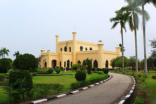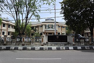
Bengkalis Regency is a regency of Indonesia in Riau Province. The regency was originally established in 1956 and then included most of the northern part of the province, but on 4 October 1999 it was divided up, with most of the territory being split off to form the new Rokan Hilir Regency, Siak Regency and the city of Dumai. On 19 December 2008 a further five districts were removed to create the new Meranti Islands Regency, leaving eight districts in the Bengkalis Regency, which quantity has increased since 2010 to eleven by the splitting of existing districts on the Sumatran mainland.

Jombang Regency is a regency of East Java, Indonesia, situated to the southwest of Surabaya. The capital of the regency is the town of Jombang. The regency has an area of 1,159.48 km2 and population of 1,202,407 at the 2010 census and 1,318,062 at the 2020 census; the official estimate as at mid 2022 was 1,335,972. It became a regency in 1910. It was the birthplace of Abdurrahman Wahid, the 4th president of Indonesia.

Pamekasan Regency is a regency (kabupaten) of the province of East Java, Indonesia. It is located on Madura Island approximately 120 kilometres (75 mi) east of Surabaya, the provincial capital. The regency covers an area of 792.30 square kilometres (305.91 sq mi), and at the 2010 census it had a population of 795,918 ; at the 2020 census the total was 850,057 and the official estimate as at mid 2022 was 857,818 – comprising 420,612 males and 437,206 females. The administrative capital is the town of Pamekasan.

Pelalawan is a regency (kabupaten) of Riau Province, Indonesia. It is located on the island of Sumatra. The regency was created on 4 October 1999 as a result of the division of Kampar Regency, of which it was previously the eastern 43%. It now has an area of 13,408.72 km² and had a population of 301,829 at the 2010 Census and 390,046 at the 2020 Census; the official estimate as at mid 2022 was 410,988. The administrative centre is in the town of Pangkalan Kerinci.

Indragiri Hulu is a landlocked regency (kabupaten) of Riau, Indonesia. It is located on the island of Sumatra. The original regency was split in two on 4 October 1999, with the western half being created as a separate Kuantan Singingi Regency. The regency now has an area of 8,198.71 km2 and had a population of 363,442 at the 2010 census, 408,704 at the 2015 census and 444,548 at the 2020 census; the official estimate as at mid 2022 was 464,076. The administrative seat of the regency is located at the town of Rengat.

Kampar is a regency (kabupaten) of Riau Province of Indonesia. The regency formerly included a much larger part of Riau Province, but on 4 October 1999 the western districts were split off to form a separate Rokan Hulu Regency, and the eastern districts were split off to form a new Pelalawan Regency. It now has an area of 11,289.28 km2 and had a population of 686,204 at the 2010 Census, and 841,332 at the 2020 Census; the official estimate as at mid 2022 was 878,210. The administrative centre of the regency is located at Bangkinang town.

Kuantan Singingi is a regency (kabupaten) of Riau, Indonesia. It is located on the island of Sumatra. The regency was created on 4 October 1999 from what had been the western half of Indragiri Hulu Regency. It has an area of 7,656.03 km² and had a population of 292,116 at the 2010 Census and 334,943 at the 2020 Census; the official estimate as at mid 2022 was 345,850. The seat of the regency is the town of Teluk Kuantan.

Rokan Hilir is a regency (kabupaten) of Riau Province, on Sumatra island, Indonesia. It was formed on 4 October 1999 from districts which had previously been the northwestern part of Bengkalis Regency. It occupies the lower part of the catchment area of the Rokan River, and has an area of 8,851.59 km2. It had a population of 553,216 at the 2010 census and 637,161 at the 2020 census; the official estimate as at mid 2022 was 638,407. The administrative centre of the Rokan Hilir Regency is located at the town of Bagansiapiapi.

Siak, is a regency (kabupaten) of Riau Province, on the island of Sumatra, Indonesia. It has an area of 8,556.09 km² and had a population of 376,742 at the 2010 Census and 457,940 at the 2020 Census; the official estimate as at mid 2022 was 477,550, comprising 246,186 males and 231,364 females. The administrative centre of the regency is located at Siak Sri Indrapura. The northern part of this regency contains a large part of the Bukit Batu Biosphere Reserve.

South Hulu Sungai Regency is one of the regencies (kabupaten) in South Kalimantan province, Indonesia. It had an area of 1,804.94 km2, and a population of 212,485 at the 2010 Census and 228,006 at the 2020 Census; the official estimate as at mid 2022 was 232,212. The capital of the regency is the town of Kandangan, which is famous for its culinary ketupat Kandangan.

Central Hulu Sungai Regency is one of the regencies in the Indonesian province of South Kalimantan. The area is 1,770.77 km2 and the population was 243,460 at the 2010 Census and 258,721 at the 2020 Census; the official estimate as at mid 2022 was 263,061. The administrative centre is the town of Barabai.

North Hulu Sungai Regency is one of the regencies in the Indonesian province of South Kalimantan. It formerly covered a larger area in the north of the province, but on 25 February 2003 the eastern districts were split off to create a separate Balangan Regency. It now has an area of 907.49 km2, and had a population of 209,246 at the 2010 Census and 226,727 at the 2020 Census; the official estimate as at mid 2022 was 231,290. The capital of the regency is the town of Amuntai.

Aceh Tamiang Regency is a regency in the east of Aceh province of Indonesia, bordering on North Sumatra Province to the east. It is located on the island of Sumatra. The regency covers an area of 1,957.02 square kilometres and had a population of 251,914 people at the 2010 census, 277,766 at the 2015 census and 294,356 at the 2020 Census; the official estimate as at mid 2022 was 301,492 - comprising 152,937 males and 148,555 females. The seat of the regency government is at the town of Karang Baru.

Southwest Aceh Regency is a regency in the Aceh Province of Indonesia. The regency was created on 10 April 2002 from the northwestern districts of South Aceh Regency. It is located on the west side of the island of Sumatra. The regency covers an area of 1,882.99 square kilometres and according to the 2010 census had a population of 126,036; this rose to 140,366 at the 2015 Census, and to 150,775 at the 2020 Census; the official estimate as at mid 2022 was 155,046. The seat of the regency government is at Blangpidie.

Pidie Jaya Regency is a regency in the Aceh Special region of Indonesia. It is located on the island of Sumatra. The regency was created out of the former northeast districts of Pidie Regency on 2 January 2007. The seat of the regency government is at Meureudu. The regency covers an area of 952.11 square kilometres and had a population of 132,956 people at the 2010 Census and 158,397 at the 2020 Census; the official estimate as at mid 2022 was 162,771 - comprising 80,946 males and 81,825 females.

Boalemo is a regency of Gorontalo Province, Indonesia. It is located on the northern peninsula of the island of Sulawesi. It was established in 1999 under Law Number 50/1999. It has an area of 1,831.33 km2, and had a population of 129,253 at the 2010 Census and 145,868 at the 2020 census; the official estimate as at mid 2022 was 148,526. The seat of the regency administration is the town of Tilamuta.

Nduga Regency is one of the regencies (kabupaten) in the Indonesian province of Highland Papua. Nduga Regency was created on 4 January 2008 by separation from Jayawijaya Regency in accordance with Law No. 6/2008. It covers an area of 12,941 km2, and had a population of 79,053 at the 2010 Census and 106,533 at the 2020 Census; the official estimate as at mid 2022 was 109,630 - comprising 59,587 males and 50,043 females. The administrative centre is at the town of Kenyam.

Mimika Regency is one of the regencies (kabupaten) in the Indonesian province of Central Papua. It covers an area of 21,693.51 km2, and had a population of 182,001 at the 2010 Census, but grew to 311,969 at the 2020 Census. The official estimate as at mid 2022 was 321,657. The administrative centre is the town of Timika, which lies within Mimika Baru District, which had 144,893 inhabitants in mid 2021.

East Flores Regency is a regency in East Nusa Tenggara province of Indonesia. Established in 1958, the regency has its seat (capital) in Larantuka on Flores Island. It covers a land area of 1,812.85 km2, and it had a population of 232,605 as of the 2010 census and 276,896 at the 2020 Census; the official estimate as at mid 2022 was 288,897. The regency encompasses the eastern tip of the island of Flores, together with all of the adjacent islands of Adonara and Solor to the east of Flores, with some much smaller offshore islands. In 1999 the island of Lembata at the eastern end of the Solor Archipelago was separated out to create its own Regency.

East Kotawaringin Regency is one of the thirteen regencies which comprise the Central Kalimantan Province on the island of Kalimantan (Borneo), Indonesia. It originally covered a much larger part of the province, but on 10 April 2002 several districts in the west of the regency were split off to form the new Seruyan Regency, and several districts in the east of the regency were similarly split off to form the new Katingan Regency. The population of the residual East Kotawaringin Regency was 374,175 at the 2010 Census, and 428,900 at the 2020 Census; the official estimate as at mid 2022 was 436,079. The town of Sampit is the capital of East Kotawaringin Regency.


