'Circus (building)' redirects here. For the British English use of circus to describe circular housing projects, see crescent (architecture).
A Roman circus (from the Latin word that means "circle") was a large open-air venue used mainly for chariot races, although sometimes serving other purposes. It was similar to the ancient Greekhippodrome. Along with theatres and amphitheatres, circuses were one of the main entertainment venues at the time.
Similar buildings, called stadia were used for Greek-style athletics particularly in the eastern, Greek speaking, part of the empire, but these were typically smaller than circuses.
According to Edward Gibbon the Roman people, at the start of the 5th century AD:[1]
...still considered the Circus as their home, their temple, and the seat of the republic.
Architectural design
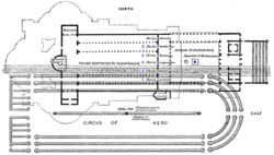
Floorplan of Circus Maximus. This design is typical of Roman circuses.
The performance space of the Roman circus was normally, despite its name, an oblong rectangle of two linear sections of race track, separated by a median strip running along the length of about two thirds the track, joined at one end with a semicircular section and at the other end with an undivided section of track closed (in most cases) by a distinctive starting gate known as the carceres, thereby creating a circuit for the races. The Circus Maximus epitomises the design.
The median strip was called the spina and usually featured ornate columns, statues and commemorative obelisks. The turning points on either end of the spina were usually marked by conical poles, called the metae (singular: meta).[2]
The track of the circus was normally surrounded by ascending seating along the length of both straight sides and around the curved end, though there were sometimes interruptions in the seating to provide access to the circus or the seating, or to provide for special viewing platforms for dignitaries and officials. One circus, that at Antinoöpolis (Egypt), displays a distinct gap of some 50m between the carceres and the start of the ascending seating where there is apparently no structure. This appears to be an exception.
The great majority of circuses fit the description above. Those that do not display two different variations: that at Emerita Augusta (Mérida, Spain), where the carceres end is substituted by a slightly curved 'straight' end joined to the straight sides of ascending seating by rounded corners of ascending seating; and a few in which the carceres end is substituted by a second semi-circular end to produce an oval shaped arena. These latter circuses are normally small (Nicopolis (Greece) and Aphrodisias (Turkey)), and should probably be considered stadia.
Common characteristics
Dates
Differently from other major Roman structures circuses frequently evolved over long periods of time from a simple track in a field, through generations of wooden seating structures (frequently destroyed by fire or rot), before they finally began to be converted to stone. Although circuses such as the Circus Maximus (Italy) may have existed in some form from as early as around 500 BC, circuses were mainly constructed during the 400 years between 200 BC and 200 AD.[3]
Dimensions
Circus, with chariot-race going on: the central division (spina) with its dolphin fountains, and the conical metae. Astarte on her lion, placed on the spina, being the tutelary goddess of Carthage, may indicate that this is the Circus of Carthage. After engraving in sard, much enlarged in the drawing; found at Binchester (Binovium).
The comparative dimensions of a circus may be measured in two basic ways: by the length of the track, and by the seating capacity. Other dimensions, such as the external dimensions of the structure may vary considerably depending on the location, the site, and on specific architectural characteristics.
The simplest comparative measurement of a circus is its track length. This is the most easily measured dimension, as it only requires small excavations at either end of the centreline. It is very probable that this can be done even when the circus is buried under subsequent constructions. Track lengths may vary from the 245 m of the circus at Gerasa (Jordan), to the 621 m of the Circus Maximus (Italy).
The alternative comparative dimension is that of seating capacity. This is much more complex to measure as it requires that the dimensions of the original vertical and horizontal extent of the inclined seating be re-established. In many cases the full structure of the inclined seating has been destroyed beyond the point where this can be measured, or at the least would require a great deal more excavation than that required for the measurement of the track length. Seating capacity may vary from around 15,000 people at Gerasa (Jordan), to 150,000 (some estimates put it up to 250,000) at the Circus Maximus (Italy).
Orientation
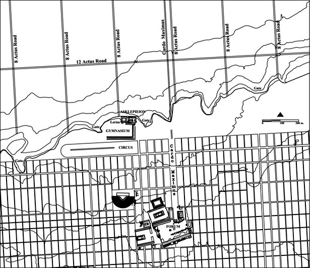
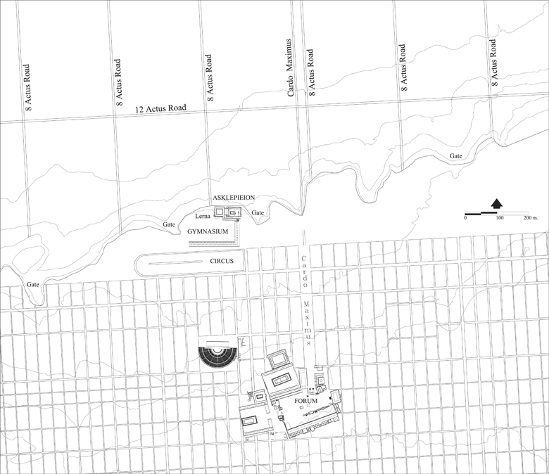
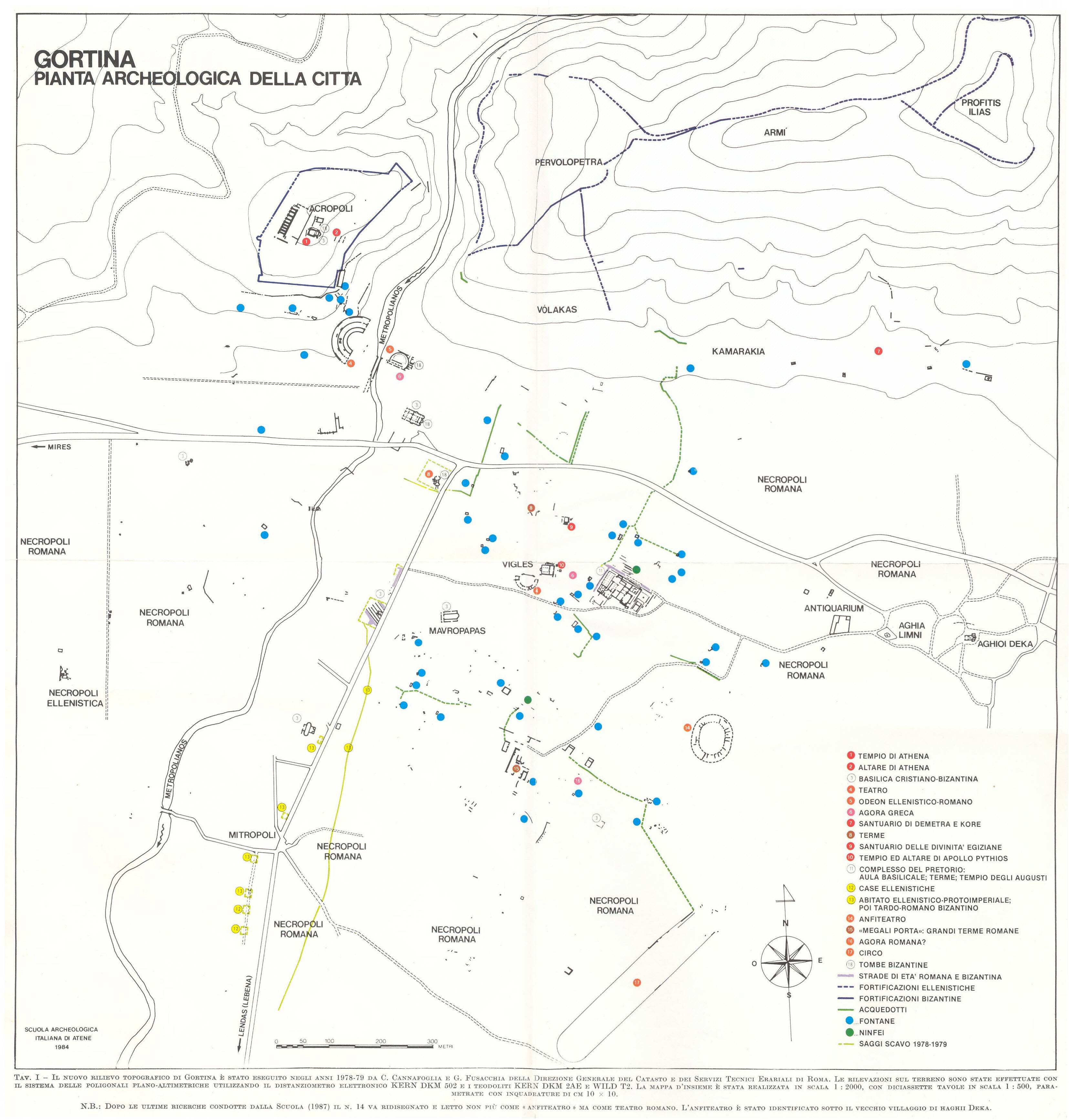
Circuses do not appear to have been constructed with any special compass orientation. Those that are well identified can be found with their round ends oriented around the compass. Examples include: N. Gerasa (Jordan); NE. Antinoöpolis (Egypt); E. Circus of Maxentius (Italy); E. Colchester (Britain); SE. Circus Maximus (Italy); S. Tyrus (Lebanon); SW. Gortyn (Greece); W. Circus of Nero (Italy).
Relative location
Circuses can be found at three distinct locations relative to the towns to which they belong:
outside the city walls at anything up to 1.5km distant, as at: Gerasa (Jordan) (c300m), and Leptis Magna (Libya) (1.5km).
simply within the town walls, as at: Thessalonica (Greece).
inside the walls, in the heart of the town, and an integral part of the architectural power structure of the town, as at: Rome, Sirmium (Serbia) and Tarraco (Spain).
Carceres
The carceres, or starting gates, had a distinctive, slanted, slightly curved, plan form, designed to compensate for what would otherwise be significant differences in the distances from the individual starting gates to the start of the first section of straight track on the right hand side of the spina (as seen from the carceres). The carceres were designed for the races to be run round the spina in an anticlockwise direction.
The form of the carceres appears to have been standardised throughout the Roman world. The similarity in form among the carceres of circuses of many different sizes suggests that carceres were constructed according to a series of proportional mathematical relationships or formulas. It is not clear when the earliest carceres of the standardised form was constructed, nor whether there exists documentary evidence for the existence of such formulas.
Some of the best examples of carceres can be found at: Gerasa (Jordan) and the Circus of Maxentius (Italy).
Unless otherwise indicated the coordinates in the following list are of a point that lies within the space of a circus. For the remaining circuses (those whose detailed location is not known) the point is for a location within the space of the historic nucleus of the associated town, or for a location within the associated archaeological site. These points are probably within 1.5 kilometres of the site of the circus, as a circus was almost always within this distance from its associated town.
(ordered initially by country; number of circuses at latest count (2012-04-01): 63)
City (Roman name) Link to detailed circus article
City (modern name)
Country
Coordinates
Notes References (sorts on length and precision of location)
cited in Humphrey;[6] approximate location confirmed by old air photographs (90% of the circus has now been built over);[8] only the southern, curved, end remains visible; U-shaped; approximate (formerly visible) track length: c450m;[8] approximate (formerly visible) track width: c70m.[8]
cited in Humphrey;[6] visible track length: 300–350 m;[9] visible track width: c45m;[9] U-shaped; the carceres are c50m beyond the ends of the ascending seating at the open south-west end; clearly visible and unobstructed.
The only known chariot racing track in Britain. Discovered in 2004 by Colchester Archaeological Trust, c.450m long x 75m wide and it consisted of a long, narrow U-shaped arena with evidence of eight starting-gates and a central archway at the square (west) end, and tiered seating-stands (cavea) around the rest of the circuit. There were passageways through the seating-stands all round the circuit to provide access for the spectators (and there would have been a large archway in the curved end). A central barrier known as a spina ran down the centre, c.239m long. Colchester Roman Circus [10], archaeological information;[11] official archaeological information;[12] length: c450m;[12] width: c75m.[12]
Arelate (Colonia Iulia Paterna Arelatensium Sextanorum)
cited in Humphrey;[6] official archaeological information;[13] c40% of curved south-west end is minimally visible; the remaining structure lies to the north-east under a road junction and housing; length: c450m;[14][15] width: c101m;[14][15] visible track width: c80m.[16]
discussion about the evidence for a circus;[25] plan showing the hypothesised location of the circus[26] and;[27] hypothesised and partially excavated location.[28]
cited in Chase;[19] archaeological city plan;[29] visible track length: c375m;[30] visible track width: c50m;[30] U-shaped plan form clearly visible; space 30% open agricultural land, 70% covered by orchard trees.
referred to as a stadium;[32] very small for a circus; visible track length: c215m;[32] visible track width: c20m;[32] double-U-shaped plan form with both rounded ends clearly visible; the space is unoccupied by any modern structures.
location[33] (the circus is marked 'Ancient Hippodrome'); archaeological map of historical centre of town,[34] showing location of hippodrome/circus (in Greek; hippodrome = Ιππόδρομος); approximate length inferred from[33] and:[34] c525m.
cited in Humphrey;[6] referred to as a hippodrome;[35] on the coast; parallel to the coast; visible track length: c290m;[36] visible track width: c45m;[36] U-shaped plan form clearly visible; structure substantially complete; few modern structures constructed within the space.
c1km inland from the coast; visible track length: c410m;[37] visible track width: c80m;[37] form substantially visible; apparently U-shaped; the space is unoccupied by any modern structures.
cited in Humphrey;[6](in Italian);[40] information and photos in English;[41] (track?) length: 328.50m;[40] (track?) width: 60m;[40] location centred on the only visible remains – three stone arches[42] (part of the carceres).
Cited in Chase;[19] location;[43][44] track length: 460m;[45] track width: 67/68m;[45] the principal visible remains are a tower at the north western corner of the circus;[46] the main body of the circus lay SSE of this tower.
Cited in Humphrey;[6] it is not entirely clear whether this 'structure' was, in fact, a circus or stadium of the form of the others in this list; Wikimapia location;[47] estimates of size are: length 260–500 m,[48][49] width 100m.[49]
Visible track length: c490m;[50] visible track width: c80m;[50] form clearly visible; U-shaped; the space is unoccupied by any modern structures; many parts of the structure are visible.
Track length: c621m;[52] track width: c150m;[52] form substantially visible; U-shaped; the space is practically unoccupied by any modern structures; only a few parts of the structure are visible or remain.
Cited in Humphrey;[6] location just to the south of St. Peter's Basilica well established, though exact position and orientation unknown; the only surviving remains are the obelisk which was brought from Egypt to adorn the spina in 37 AD;[53] the obelisk was moved to its current location in Saint Peter's Square in 1586.[54]
cited in Humphrey;[6] visible track length: c245m;[61] visible track width: c50m;[61] form clearly visible; U-shaped; the space is unoccupied by any modern structures; a great deal of the structure still stands.
cited in Humphrey;[6] the location is of the archaeological site of the Beirut Hippodrome as given on Wikimapia;[63] this may, or may not, be the same structure as the circus.
cited in Humphrey;[6] visible track length: c435m;[64] visible track width: c80m;[64] form clearly visible; U-shaped; the space is unoccupied by any modern structures; a great deal of the structure is still visible.
cited in Humphrey;[6] visible track length: c300m?;[66][67] visible track width: c45m;[66][67] form reasonably visible; U-shaped; the space is unoccupied by any modern structures; little of the structure is still visible; sometimes referred to as a hippodrome.
cited in Humphrey;[6] located both on and parallel to the sea shore; visible track length: c445m;[68] visible track width: c75m;[68] form clearly visible; U-shaped; the space is unoccupied by any modern structures; some of the structure is still visible.
believed to have existed, but unconfirmed; archaeological information about the Roman town;[70][71] reference to a suggested location for the circus (Praça do Comércio); suggested location.[72]
cited in Humphrey;[6] the location is approximately that indicated conjecturally, though with considerable certainty, at;[73] that site states "the topographic marks of [the circus] permit a reasonably rigorous survey"; length: c375m;[73] width: c80m.[73]
cited in Chase;[19] visible track length: c330m;[74] visible track width: c70m;[74] form clearly visible; U-shaped; the space is unoccupied by any modern structures; little of the structure is still visible.
cited in Humphrey;[6] the location is a close approximation based on information at;[77] length: c450m;[78] width: c150m;[78] the structure lies buried some 2–4 m under the current town centre, just to the north of the partially excavated palace; only very small sections have been excavated.[77]
cited in Humphrey;[6] the location, from Wikimapia[81] and Spanish Wikipedia[82] is of the ruins of the Roman city only; there is no indication of the location of the circus.
Cited in Humphrey;[6] visible track length: c400m;[85] visible track width: c85m;[85] form clearly visible; U-shaped but without the distinctive slanted 'flat' carceres end seen in many other circuses; instead the 'flat' end is slightly rounded; the space is unoccupied by any modern structures; much of the structure is still visible.
cited in Humphrey;[6] very approximate location;[87] the circus lies under the centre of the existing old town of Santiponce; nothing is visible; note that the very large amphitheatre at Italica is sometimes referred to as a circus.
cited in Humphrey;[6] the location of the circus has been confirmed by the excavation, and preservation, of a gate to the circus;[88][89] the circus lies buried under the existing town; only the gate is visible;[90] length: c350m;[91] width: c73m.[91]
cited in Humphrey;[6] most of the circus lies buried under the existing town; a substantial part of the curved eastern end, and part of the south-western side, are visible; track length: c290m;[93] track width: c75m.[93]
Cited in Humphrey;[6] between a third and a half of the circus, including the round end, is partially visible; the remainder of the circus, has either been obliterated, or lies under modern constructions; suggested length: c430m;[95][96] visible width: c75m.[97]
cited in Humphrey;[6] there appears to be significant uncertainty about the status, and even name, of Zafra in the Roman era;[98] the town appears to have no significant Roman remains other than those of some 20 Roman villas in the surrounding area;[98] no online circus-specific information found.
cited in Humphrey;[6] French maps of Roman Bosra showing the location of the circus (or hippodrome);[99][100] visible track length: c430m;[101] visible track width: c110m;[101] form clearly visible; U-shaped; the space is virtually unoccupied by any modern structures; much of the structure still stands.
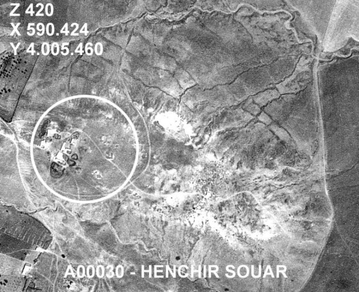
cited in Humphrey;[6] coordinates of place;[105] location of place on topographic map[106] (ref: NJ32-15/510322); references to Henchir Souar;[107][108] aerial photograph of place[109] confirms coordinates reference; topographic features on aerial photograph match with;[110] no online circus-specific information found.
Cited in Humphrey;[6] location;[111] length: c500m;[111][112] width: c90m;[111][112] U-shaped; very little remains visible; partly occupied by modern constructions.
cited in Humphrey;[6] archaeological document of Tunisian government[113](in French); location of place on topographic map[106] (ref: NJ32-15/498358); no online circus-specific information found.
Hadrumetum OR Colonia Concordia Ulpia Trajana Augusta Frugifera Hadrumetina
cited in Humphrey;[6] probable location[114] based on information in 1903 documents[115](in French), reinforced by an undated aerial photograph;[116] visible length (as measured on Wikimapia based on cross-reference with aerial photograph): c350m or greater.
Thugga OR Municipium Septimium Aurelium Liberum Thugga[117]
cited in Chase;[19] approximate location,[118] on the north western edge of town, suggested (though not explicitly identified) on plan,[119] and plan;[120] various lengths are referenced: c175m,[121] 393m;[122] the site is open agricultural land with no subsequent occupation.
cited in Humphrey;[6] visible track length: c500m;[124] visible track width: c70m;[124] form lightly visible; U-shaped; the space is unoccupied by any modern structures; little of the structure is still visible.
cited in Humphrey;[6] Tunisian archaeological site number: 007.157 (Utique; Henchir Bechateur; UTIKA);[126] reference to circus;[127] uncorroborated location;[128] more probable location[129] as indicated by the maps in[130] confirms the given location; approximate length measured from the maps in:[130] 280-300m.
cited in Humphrey;[6] location (from 1930s aerial photograph);[131] map[132] of ancient Antioch[133] showing the circus as a hippodrome; length: c490m;[131][134] width: c90m;[131][134] very little visible today; is more visible in a 1930s aerial photograph;[131] lightly over-built by modern structures and occupations.
Double-U-shaped; very substantially preserved; significantly smaller than other circuses; may be considered a stadium or hippodrome rather than a circus; visible track length: c220m;[135] visible track width: 35m.[135]
Built under Septimius Severus; estimated length: c450m;[137] estimated width: c130m;[137] other than some monuments from the spina, virtually none of the structure is visible today; it is believed much of the structure may lie buried some 2m below the current surface.[138]
referred to as a stadium; double U-shaped and small; visible track length: c250m;[140] visible track width: c40m;[140] form clearly visible; no visible spina; unoccupied by any subsequent construction.
cited in Humphrey;[6] general information on the archaeological remains of Nicomedia;[141][142] Kocaeli municipal history,[143] including a 19th-century map showing the location of the historic nucleus of the city (through history Kocaeli has been named successively: Olbia, Astakos, Nicomedia, Iznikmid, and Izmid or Izmit); no online circus-specific information found.
↑ Michael Gagarin; Elaine Fantham, eds. (2009). The Oxford Encyclopedia of Ancient Greece and Rome, Volume 1. Oxford University Press. p.146. ISBN978-0-19-517072-6.
1 2 3 4 5 Raymond G. Chase: Ancient Hellenistic and Roman amphitheatres, stadiums, and theatres: the way they look now. P. E. Randall, Portsmouth 2002, ISBN1-931807-08-6
↑ [Olissipona] A Cronologia do Circo de Olisipo by IPPAR (now IGESPAR); published as: Revista Portuguesa de Arqueologia. volume 5. número 2. 2002, pp 245–275, "A Cronologia do Circo de Olisipo: a Terra Sigillata", Eurico Sepúlveda and others.
This page is based on this Wikipedia article Text is available under the CC BY-SA 4.0 license; additional terms may apply. Images, videos and audio are available under their respective licenses.


