
Roman roads in Morocco were the western roads of Roman Africa.
Roman roads in Morocco were the western roads of Roman Africa.
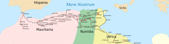
In 42 AD, the western part of the kingdom of Mauretania was reorganized as a province of Rome Mauretania Tingitana. During the reign of emperor Claudius (41–54) infrastructure was improved.
A road leading in the southern direction from Tingis split in two at Ad Mercuri (possibly modern Bled Mers [1] ).
One of the two followed the Atlantic coast through Iulia Constantia Zilil (Dchar Jdid), [2] Lixus (Larache) and Sala Colonia (near Rabat).
The other, more to the east, ended in Tocolosida, near Volubilis and modern Fez.
There is the possibility that a Roman road was built toward south, from Sala Colonia to Anfa (or Anfus), in the area of modern Casablanca, where there was a small port used by the Phoenicians and later the Romans since 15 BC. [3] This port was used for Roman expeditions toward the Canary Islands.
There was another important road that connected Mauretania Tingitana with Mauretania Caesariensis (modern western Algeria). It ran from Tamuda to Numerus Syrorum. [4]
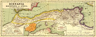
Mauretania is the Latin name for a region in the ancient Maghreb. It extended from central present-day Algeria to the Atlantic, encompassing northern present-day Morocco, and from the Mediterranean in the north to the Atlas Mountains. Its native inhabitants, of Berber ancestry, were known to the Romans as the Mauri and the Masaesyli.

Numidia was the ancient kingdom of the Numidians in northwest Africa, initially comprising the territory that now makes up Algeria, but later expanding across what is today known as Tunisia and Libya. The polity was originally divided between the Massylii state in the east and the Masaesyli in the west. During the Second Punic War, Masinissa, king of the Massylii, defeated Syphax of the Masaesyli to unify Numidia into the first unified Berber state for Numidians in present-day Algeria. The kingdom began as a sovereign state and an ally of Rome and later alternated between being a Roman province and a Roman client state.

The Via Domitia was the first Roman road built in Gaul, to link Italy and Hispania through Gallia Narbonensis, across what is now Southern France. The route that the Romans regularised and paved was ancient when they set out to survey it, and traces the mythic route travelled by Heracles.

Siga was a Berber and Roman port located near what is now Aïn Témouchent, Algeria. Under the Roman Empire, it was part of western Mauretania Caesariensis, bordering Mauretania Tingitana.

Mauretania Caesariensis was a Roman province located in present-day Algeria. The full name refers to its capital Caesarea Mauretaniae.
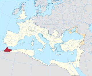
Mauretania Tingitana was a Roman province, coinciding roughly with the northern part of present-day Morocco. The territory stretched from the northern peninsula opposite Gibraltar, to Sala Colonia and Volubilis to the south, and as far east as the Mulucha river. Its capital city was Tingis, which is the modern Tangier. Other major cities of the province were Iulia Valentia Banasa, Septem, Rusadir, Lixus and Tamuda.
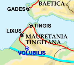
Tingis or Tingi, the ancient name of Tangier in Morocco, was an important Carthaginian, Moor, and Roman port on the Atlantic Ocean. It was eventually granted the status of a Roman colony and made the capital of the province of Mauretania Tingitana and, after Diocletian's reforms, the diocese of Hispania.

Lixus is an ancient city founded by Phoenicians before the city of Carthage. Its distinguishing feature is that it was continuously occupied from antiquity to the Islamic Era, and has ruins dating to the Phoenician, Punic, Mauretanian, Roman and Islamic periods.

The Chellah or Shalla, is a medieval fortified Muslim necropolis and ancient archeological site in Rabat, Morocco, located on the south (left) side of the Bou Regreg estuary. The earliest evidence of the site's occupation suggests that the Phoenicians established a trading emporium here in the first millennium BC. This was later the site of Sala Colonia, an ancient Roman colony in the province of Mauretania Tingitana, before it was abandoned in Late Antiquity. In the late 13th century the site began to be used as a dynastic necropolis for the Marinid dynasty. By the mid-14th century Marinid sultans had enclosed a part of the site with a new set of walls and built a religious complex inside it to accompany their mausoleums. In the 15th century the necropolis began to decline and it suffered damage over the centuries due to earthquakes and looting. Archeological excavations in the 20th century unearthed the remains of the ancient Roman town. Today the site is a tourist attraction and since 2012 it forms part of a UNESCO World Heritage Site.
Anfa was the ancient toponym for Casablanca during the classical period. The city was founded by Berbers around the 10th century BC, with the Romans under Augustus later establishing the commercial port of "Anfus" in 15 BC. Anfa is now the name of a district in the oldest part of Casablanca, located in the Casablanca-Settat region of Morocco. The district covers an area of 37.5 square kilometres, and as of 2004 had 492,787 inhabitants.

Tamuda was an ancient Berber city and military camp in Mauretania Tingitana. It is located 6 km west of the present-day Tetouan in northern Morocco. Stone ruins from the site are found by the south bank of the Martil Valley. It was considered a city in accordance with the rules of urbanization of the time.

Mauretania Sitifensis was a Roman province in Northwest Africa. The capital was Setifis.

Iulia Constantia Zilil was an ancient Roman-Berber city in Dchar Jdid, located 40 km southwest of Tangier and 13 km northeast of Asilah. It was one of the three colonias in Mauretania Tingitana founded by emperor Augustus between 33 and 25 BC for veterans of the battle of Actium.

Iulia Valentia Banasa was a Roman-Berber city in northern Morocco. It was one of the three colonias in Mauretania Tingitana founded by emperor Augustus between 33 and 25 BC for veterans of the battle of Actium, on top of a Mauretanian village. The site was in fact already occupied by the local Amazigh people from the 4th century BC, or perhaps earlier.

Almost all Roman roads in Africa were built in the first two centuries AD. In 14 AD, Legio III Augusta completed a road from Tacape to Ammaedara: the first Roman road in Africa. In 42 AD, the kingdom of Mauretania was annexed by Rome. Emperor Claudius then restored and widened a Carthaginian trail and extended it west and east. This way the Romans created a continuous coastal highway stretching for 2,100 miles from the Atlantic to the Nile. In 137, Hadrian built the Via Hadriana in the eastern desert of Egypt. It ran from Antinoopolis to Berenice.

Thamusida was a Punic river port that was in the present-day towns of Kénitra and Mehdya in Morocco. Under the Roman Empire, it formed a part of the province of Mauretania Tingitana.
Iulia Campestris Babba is a Mauretanian city created as Roman colony around 30 BC by emperor Augustus. Its actual location is currently unknown, though its existence is confirmed by the literature.

Roman colonies in North Africa are the cities—populated by Roman citizens—created in North Africa by the Roman Empire, mainly in the period between the reigns of Augustus and Trajan.

Tocolsida is a site in modern Morocco, with the remains of an ancient castra from the Roman Province of Mauretania Tingitana, Roman Empire.
The Limes Mauretaniae was a portion of a 4,000-kilometre (2,500 mi) Roman fortified border (limes) in Africa approximately 100 kilometres (62 mi) south of the modern day Algiers.