Ridgeway is an unincorporated community located within Manchester Township, in Ocean County, New Jersey, United States.

Lake Tear of the Clouds is a small tarn located in the town of Keene, in Essex County, New York, United States, on the southwest slope of Mount Marcy, the state's highest point, in the Adirondack Mountains. It is the highest pond in the state. It is often cited as the highest source of the Hudson River, via Feldspar Brook, the Opalescent River and Calamity Brook.

Blue Mountain, Blue Mountain Ridge, or the Blue Mountains of Pennsylvania is a ridge of the Appalachian Mountains in the U.S. state of Pennsylvania. Forming the southern and eastern edge of the Ridge-and-Valley Appalachians physiographic province in Pennsylvania, Blue Mountain extends 150 miles (240 km) from the Delaware Water Gap on the New Jersey border in the east to Big Gap in Franklin County, south-central Pennsylvania, at its southwestern end.

The South Branch Raritan River is a 50-mile-long (80 km) tributary of the Raritan River in New Jersey.
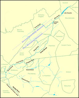
Bound Brook is a tributary of the Raritan River in Middlesex County, New Jersey, in the United States.

Papakating Creek is a 20.1-mile-long (32.3 km) tributary of the Wallkill River located in Frankford and Wantage townships in Sussex County, New Jersey in the United States. The creek rises in a small swamp located beneath the eastern face of Kittatinny Mountain in Frankford and its waters join the Wallkill to the east of Sussex borough.
The Branch is a 2.6-mile-long (4.2 km) river located entirely in the city of Keene, in southwestern New Hampshire in the United States. It is a tributary of the Ashuelot River, itself a tributary of the Connecticut River, which flows to Long Island Sound.

Beards Brook or Beard Brook is a 12.5-mile-long (20.1 km) stream located in southern New Hampshire in the United States. It is a tributary of the North Branch of the Contoocook River, part of the Merrimack River watershed.
The Stroudwater River is a 15.2-mile-long (24.5 km) river located mostly in Cumberland County, Maine. The river begins as a small stream at Duck Pond in Buxton and grows as it flows through Buxton, Gorham, Westbrook, and finally Portland before emptying into the Fore River at Stroudwater falls in Portland's Stroudwater neighborhood. Several smaller streams flow into the river in Buxton and Gorham, including Deering Brook, Gully Brook, Fogg Brook and Silver Brook.

Pleasant Run was a hamlet in Readington Township, Hunterdon County, New Jersey, United States. Located along Campbell's Brook, the hamlet consisted of farms, a schoolhouse and a general store. The brook was named after John Campbell, who purchased the land around it in 1685.

Pecks Corner is an unincorporated community located within Quinton Township in Salem County, New Jersey, United States. It is located at the intersection of County Route 667 and Route 49.

Quarryville is an unincorporated community located within Wantage Township in Sussex County, New Jersey, United States.

Jericho is an community located within Stow Creek Township, in Cumberland County, New Jersey, United States.
Zion is an unincorporated community along the border of Hillsborough Township and Montgomery Township in Somerset County, New Jersey, United States. It is located on Rock Brook, approximately 3 mi (4.8 km) north of Hopewell.

Sand Brook is an unincorporated community located within Delaware Township in Hunterdon County, New Jersey, United States.

Ernston is a neighborhood in Sayreville in Middlesex County, New Jersey, United States. It was a stop on the Camden and Amboy Railroad. In 1876, when the newly-formed Township of Sayreville was created from approximately 14 square miles (36 km2) of South Amboy's surroundings, Ernston was consolidated with Morgan, Melrose, and Sayre's Village under one municipal government.
Flatbrookville is an unincorporated community located within Walpack Township, in Sussex County, New Jersey, United States. It is located near the Flat Brook, a tributary of the Delaware River.

Miami Beach is an unincorporated community in Lower Township in Cape May County, New Jersey, United States.
Trout Brook is a stream in Ramsey County, in the U.S. state of Minnesota. It source is at McCarrons Lake.


