
Rockaway is a borough in Morris County, in the U.S. state of New Jersey. As of the 2020 United States census, the borough's population was 6,598, an increase of 160 (+2.5%) from the 2010 census count of 6,438, which in turn reflected a decline of 35 (−0.5%) from the 6,473 counted in the 2000 census.

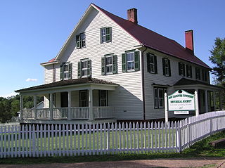
Rockaway Township is a township in Morris County, in the U.S. state of New Jersey. As of the 2020 United States census, the township's population was 25,341, an increase of 1,185 (+4.9%) from the 2010 census count of 24,156, which in turn reflected an increase of 1,226 (+5.3%) from the 22,930 counted in the 2000 census.

Newfoundland is an unincorporated community and census-designated place (CDP), geographically spanning both West Milford Township in Passaic County, and Jefferson Township in Morris County, in the U.S. state of New Jersey. It is located along Route 23 and is the mailing address of Green Pond, a private lake in Rockaway Township. As of the 2020 United States census, the CDP's population was 1,145.

Thorofare is an unincorporated community and census-designated place (CDP) located within West Deptford Township in northwestern Gloucester County, situated in the South Jersey region of the U.S. state of New Jersey. The area is served as United States Postal Service ZIP Code 08086. As of the 2020 United States census, the CDP's population was 2,806. As of the 2000 census, the population of a different geographic entity containing Thorofare, namely ZIP Code Tabulation Area 08086, was 5,424.

Port Elizabeth is an unincorporated community located within Maurice River Township in Cumberland County, New Jersey, United States. The area is served as United States Postal Service ZIP code 08348.

Clarksburg is an unincorporated community located within Millstone Township in Monmouth County, in the U.S. state of New Jersey. The area is served as United States Postal Service ZIP code 08510.
Cookstown is an unincorporated community and census-designated place (CDP) located within New Hanover Township in Burlington County, New Jersey, United States. Located near Fort Dix, the area is served as United States Postal Service ZIP Code 08511.
Newport is an unincorporated community located within Downe Township in Cumberland County, New Jersey, United States. The area is served as United States Postal Service ZIP code 08345.
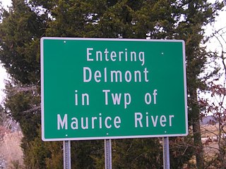
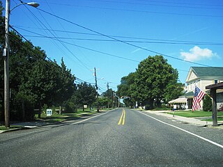
Delmont is an unincorporated community and census-designated place located within Maurice River Township, in Cumberland County, in the U.S. state of New Jersey. The area is served as United States Postal Service ZIP Code 08314. It was first listed as a CDP in the 2020 census with a population of 122.

Pine Brook, sometimes spelled Pinebrook, is a census-designated place and unincorporated community located within Montville in Morris County, in the U.S. state of New Jersey. As of the 2020 United States census, the CDP had a population of 5,675.

Layton is an unincorporated community and census-designated place (CDP) located within Sandyston Township in Sussex County, in the U.S. state of New Jersey. The area is served as United States Postal Service ZIP code 07851.
Hewitt is an unincorporated community and census-designated place (CDP) located within West Milford Township in Passaic County, in the U.S. state of New Jersey. The area is served as United States Postal Service ZIP Code 07421. It is named for Abram Hewitt.

Gillette is an unincorporated community and census-designated place (CDP) located within Long Hill Township in Morris County, in the U.S. state of New Jersey. The area is served as United States Postal Service ZIP code 07933.
New Gretna is an unincorporated community and census-designated place (CDP) located within Bass River Township in Burlington County, in the U.S. state of New Jersey. The area is served as United States Postal Service ZIP Code 08224.
Mount Royal is an unincorporated community and census-designated place located within East Greenwich Township in Gloucester County, in the U.S. state of New Jersey. The area is served as United States Postal Service ZIP Code 08061.

Asbury is an unincorporated community and census-designated place (CDP) located within Franklin Township in Warren County, in the U.S. state of New Jersey, that was created as part of the 2010 United States Census. As of the 2010 Census, the CDP's population was 273.

Crosswicks is an unincorporated community and census-designated place (CDP) located within Chesterfield Township in Burlington County, New Jersey, United States. The area is served as United States Postal Service ZIP code 08515.

Brookside is a historic unincorporated community within Mendham Township in Morris County, New Jersey, United States. It is located approximately 6 mi (9.7 km) west of Morristown. It is close to the Washington Valley Historic District in neighboring Morris Township.

Harrisonville is an unincorporated community and census-designated place (CDP) located within South Harrison Township, in Gloucester County, New Jersey. The area is served as United States Postal Service ZIP code 08039.

The Methodist Episcopal Church, also known as the Methodist Episcopal Church of Hibernia, is a historic church built in 1869 and located at 419 Green Pond Road in the Hibernia section of Rockaway Township, Morris County, New Jersey. It was added to the National Register of Historic Places on July 14, 2011, for its significance in architecture and industry. Since 1970, the building has been used as a branch of the Rockaway Township Free Public Library.


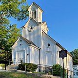 Methodist Episcopal Church, now a library
