Flanders, New Jersey

Last updated

Flanders, New Jersey
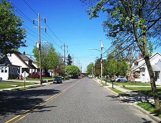
Mount Olive Village, NJ - Mount Olive Academy, looking northwest.jpg
Mount Olive Academy, built in 1837
Location map of Morris County, New Jersey.svg
Red pog.svg
Flanders
Location in Morris County
USA New Jersey relief location map.svg
Red pog.svg
Flanders
Location in New Jersey
Usa edcp relief location map.png
Red pog.svg
Flanders
Location in the United States
Coordinates: 40°50′44″N74°41′42″W / 40.84556°N 74.69500°W / 40.84556; -74.69500
Country Flag of the United States.svg  United States
State Flag of New Jersey.svg  New Jersey
County Morris
Township Mount Olive
Area
[1]
  Total7.45 sq mi (19.30 km2)
  Land7.42 sq mi (19.23 km2)
  Water0.03 sq mi (0.07 km2)
Elevation
679 ft (207 m)
Population
 (2020) [2]
  Total9,832
  Density1,324.5/sq mi (511.4/km2)
ZIP Code
07836
FIPS code 34-23640 [3]
GNIS feature ID0876369 [4]

Flanders is an unincorporated community and census-designated place (CDP) [5] located within Mount Olive Township, in southwestern Morris County, in the U.S. state of New Jersey. [6] Flanders is served by the United States Postal Service as ZIP Code 07836. [7]

Contents

Demographics

Historical population
CensusPop.Note
1990 10,528
2000 12,21716.0%
2010 12,5682.9%
2020 9,832−21.8%
Population sources:1990 [8]
2000 [9] 2010 [10] 2020 [2]

As of the 2020 United States census, the Flanders CDP's population was 9,832, [2] a decrease of 2,736 (−21.8%) from the 12,568 enumerated at the 2010 census in the Flanders ZIP Code Tabulation Area, [10] which in turn reflected an increase of 351 (+2.9%) from the 12,217 counted in the 2000 census. [9]

Notable people

People who were born in, residents of, or otherwise closely associated with Flanders include:

Related Research Articles

<span class="mw-page-title-main">Bridgeport, New Jersey</span> Populated place in Gloucester County, New Jersey, US

Bridgeport is a census-designated place (CDP) and unincorporated community that is part of Logan Township, in Gloucester County, in the U.S. state of New Jersey. At the 2020 United States census, the population of the CDP was 389. in the 2010 census, the population was 504.

<span class="mw-page-title-main">Delaware, Warren County, New Jersey</span> Census-designated place in Middlesex County, New Jersey, US

Delaware is an unincorporated community and census-designated place (CDP) located along the Delaware River within Knowlton Township in Warren County, New Jersey. It was created as part of the 2010 United States Census. As of the 2010 Census, the CDP's population was 150. The area is served as United States Postal Service ZIP Code 07833.
<span class="mw-page-title-main">Towaco, New Jersey</span> Populated place in Morris County, New Jersey, US

Towaco is an unincorporated community and census-designated place (CDP) located within Montville Township in Morris County, in the U.S. state of New Jersey. The area is served as United States Postal Service ZIP Code 07082. Its name reflects the Native American history in the area, which identified the locale as TaWagh, meaning "hill", a reference to the terrain of Towaco.

Hewitt is an unincorporated community and census-designated place (CDP) located within West Milford Township in Passaic County, in the U.S. state of New Jersey. The area is served as United States Postal Service ZIP Code 07421. It is named for Abram Hewitt.

<span class="mw-page-title-main">Richland, New Jersey</span> Populated place in Atlantic County, New Jersey, US

Richland is an unincorporated community and census-designated place (CDP) located within Buena Vista Township in Atlantic County, in the U.S. state of New Jersey. The area is served as United States Postal Service ZIP Code 08350.

Landing is an unincorporated community and census-designated place (CDP) located within Roxbury Township, in Morris County, New Jersey, United States. The community is located on the south shore of Lake Hopatcong near Hopatcong State Park. The area is served as United States Postal Service ZIP Code 07850.

<span class="mw-page-title-main">Gillette, New Jersey</span> Place in Morris County, New Jersey, United States

Gillette is an unincorporated community and census-designated place (CDP) located within Long Hill Township in Morris County, in the U.S. state of New Jersey. The area is served as United States Postal Service ZIP Code 07933.

New Gretna is an unincorporated community and census-designated place (CDP) located within Bass River Township in Burlington County, in the U.S. state of New Jersey. The area is served as United States Postal Service ZIP Code 08224.

<span class="mw-page-title-main">Asbury, New Jersey</span> Populated place in Warren County, New Jersey, US

Asbury is an unincorporated community and census-designated place (CDP) located within Franklin Township in Warren County, in the U.S. state of New Jersey, that was created as part of the 2010 United States Census. As of the 2010 Census, the CDP's population was 273.

<span class="mw-page-title-main">New Monmouth, New Jersey</span> Unincorporated community in New Jersey, United States

New Monmouth is an unincorporated community located within Middletown Township in Monmouth County, New Jersey, United States. The area is served as United States Postal Service ZIP code 07748.

<span class="mw-page-title-main">Stewartsville, New Jersey</span> Populated place in Warren County, New Jersey, US

Stewartsville is an unincorporated community and census-designated place (CDP) located within Greenwich Township in Warren County, in the U.S. state of New Jersey, that was created as part of the 2010 United States Census. As of the 2010 Census, the CDP's population was 349.

Dorothy is an unincorporated community and census-designated place located in Weymouth Township in Atlantic County, in the U.S. state of New Jersey. The area is served as United States Postal Service ZIP Code 08317.

Great Meadows is an unincorporated community and census-designated place (CDP) located within Independence Township in Warren County, in the U.S. state of New Jersey, that was created as part of the 2010 United States Census. As of the 2010 census, the CDP's population was 303.

<span class="mw-page-title-main">Brookside, New Jersey</span> Place in Morris County, New Jersey, United States

Brookside is a historic unincorporated community and census-designated place (CDP) located within Mendham Township in Morris County, in the U.S. state of New Jersey. It is located approximately 6 mi (9.7 km) west of Morristown. It is close to the Washington Valley Historic District in neighboring Morris Township.

<span class="mw-page-title-main">Port Murray, New Jersey</span> Census-designated place in Warren County, New Jersey, United States

Port Murray is an unincorporated community and census-designated place (CDP) located within Mansfield Township in Warren County, in the U.S. state of New Jersey, that was created as part of the 2010 United States Census. As of the 2010 Census, the CDP's population was 129.

Monroeville is an unincorporated community located within portions of Elk Township in Gloucester County and Upper Pittsgrove Township in Salem County, New Jersey, United States. The area is served as United States Postal Service ZIP Code 08343. Monroeville is mostly filled with wooded areas and farms.

<span class="mw-page-title-main">Holmeson, New Jersey</span> Unincorporated community in New Jersey, United States

Holmeson is an unincorporated community located within Millstone Township in Monmouth County, New Jersey, United States. As it is located along County Route 537 through which the Monmouth–Ocean county line runs down the center, portions of the community are also located in Jackson Township. Owing to its location near Interstate 195 and Six Flags Great Adventure, the community is mostly made up of gas stations, restaurants, and small businesses though the Jackson Premium Outlets occupies land just south of the community.
<span class="mw-page-title-main">Birmingham, New Jersey</span> Unincorporated community in New Jersey, United States

Birmingham is an unincorporated community located within Pemberton Township in Burlington County, New Jersey, United States. As of the 2010 United States Census, the ZIP Code Tabulation Area for ZIP Code 08011 had a population of 33. Though sparsely populated, it houses a post office and a Lanxess chemical facility.

Hainesburg is an unincorporated community and census-designated place (CDP) located within Knowlton Township in Warren County, in the U.S. state of New Jersey. While the community has existed for over a century, the CDP was designated as part of the 2010 United States Census. As of the 2010 Census, the CDP's population was 91.

Allaire is an unincorporated community located within Wall Township in Monmouth County, New Jersey, United States. As of the 2010 United States Census, the ZIP Code Tabulation Area for ZIP Code 07727 had a population of 7,050.

References

  1. "ArcGIS REST Services Directory". United States Census Bureau. Retrieved October 11, 2022.
  2. 1 2 3 QuickFacts Flanders CDP, New Jersey, United States Census Bureau. Accessed June 20, 2023.
  3. Geographic Codes Lookup for New Jersey, Missouri Census Data Center. Accessed June 9, 2023.
  4. "Flanders". Geographic Names Information System . United States Geological Survey, United States Department of the Interior . Retrieved September 24, 2012.
  5. State of New Jersey Census Designated Places - BVP20 - Data as of January 1, 2020, United States Census Bureau. Accessed December 1, 2022.
  6. Locality Search, State of New Jersey. Accessed May 19, 2015.
  7. Zip Codes, State of New Jersey. Accessed May 19, 2015.
  8. DP-1: Profile of General Demographic Characteristics: 1990 from the Census 1990 Summary File 1 (SF 1) 100-Percent Data for ZCTA5 07836 [ permanent dead link ], United States Census Bureau. Accessed May 19, 2015.
  9. 1 2 DP-1: Profile of General Demographic Characteristics: 2000 from the Census 2000 Summary File 1 (SF 1) 100-Percent Data for ZCTA5 07836 Archived 2020-02-13 at archive.today , United States Census Bureau. Accessed May 19, 2015.
  10. 1 2 DP-1: Profile of General Population and Housing Characteristics: 2010 from the 2010 Demographic Profile Data for ZCTA 07836 Archived 2020-02-13 at archive.today , United States Census Bureau. Accessed May 19, 2015.
  11. Shore, Phil (November 28, 2014). "Hangin' Out With Kenny Agostino (Flanders, N.J.)". New York Hockey Journal.
  12. Spaulding, Anthony. "After breaking leg in 2015, former PJ star Noah Brown to start for Ohio State on Saturday", New Jersey Herald , September 2, 2016. Accessed January 12, 2017. "Noah Brown has every reason to be pumped up for Saturday.That day at noon, the Flanders native and 2014 Pope John High School graduate is expected to start in the first NCAA Division I college football game of his career at wide receiver in the Ohio State Buckeyes' season opener against Bowling Green."
  13. "Flanders Man Gets Commerce Position". The Hackesttown Gazette. November 19, 1959.
  14. Mason, Jory Neill. "Biography - John R. Neill" . Retrieved December 27, 2020.
  15. Hilbert, Rita. Mount Olive, p. 29. Arcadia Publishing, 2001, via Google Books. ISBN   0-7385-0513-7. Accessed December 27, 2020. "Jonathan Nicholas, a barrel maker, built his home in Flanders after the Revolutionary War."
  16. Hoffman, Joe. "Mt. Olive's Rouson headed to Colorado", Daily Record , February 2, 2006. Accessed March 26, 2011.
  17. "Steve Slattery". USA Track & Field. June 6, 2008.
  18. "Wurts Family Papers". Hagley Museum and Library. August 21, 2013.
  19. John Wurts, Biographical Directory of the United States Congress . Accessed February 23, 2011.