Related Research Articles

Code-division multiple access (CDMA) is a channel access method used by various radio communication technologies. CDMA is an example of multiple access, where several transmitters can send information simultaneously over a single communication channel. This allows several users to share a band of frequencies. To permit this without undue interference between the users, CDMA employs spread spectrum technology and a special coding scheme.
The Global Positioning System (GPS), originally Navstar GPS, is a satellite-based radio navigation system owned by the United States Space Force and operated by Mission Delta 31. It is one of the global navigation satellite systems (GNSS) that provide geolocation and time information to a GPS receiver anywhere on or near the Earth where there is an unobstructed line of sight to four or more GPS satellites. It does not require the user to transmit any data, and operates independently of any telephone or Internet reception, though these technologies can enhance the usefulness of the GPS positioning information. It provides critical positioning capabilities to military, civil, and commercial users around the world. Although the United States government created, controls, and maintains the GPS system, it is freely accessible to anyone with a GPS receiver.

Time-division multiple access (TDMA) is a channel access method for shared-medium networks. It allows several users to share the same frequency channel by dividing the signal into different time slots. The users transmit in rapid succession, one after the other, each using its own time slot. This allows multiple stations to share the same transmission medium while using only a part of its channel capacity. Dynamic TDMA is a TDMA variant that dynamically reserves a variable number of time slots in each frame to variable bit-rate data streams, based on the traffic demand of each data stream.
The Universal Mobile Telecommunications System (UMTS) is a 3G mobile cellular system for networks based on the GSM standard. Developed and maintained by the 3GPP, UMTS is a component of the International Telecommunication Union IMT-2000 standard set and compares with the CDMA2000 standard set for networks based on the competing cdmaOne technology. UMTS uses wideband code-division multiple access (W-CDMA) radio access technology to offer greater spectral efficiency and bandwidth to mobile network operators.
In telecommunications and computer networking, multiplexing is a method by which multiple analog or digital signals are combined into one signal over a shared medium. The aim is to share a scarce resource – a physical transmission medium. For example, in telecommunications, several telephone calls may be carried using one wire. Multiplexing originated in telegraphy in the 1870s, and is now widely applied in communications. In telephony, George Owen Squier is credited with the development of telephone carrier multiplexing in 1910.

In telecommunications, a repeater is an electronic device that receives a signal and retransmits it. Repeaters are used to extend transmissions so that the signal can cover longer distances or be received on the other side of an obstruction. Some types of repeaters broadcast an identical signal, but alter its method of transmission, for example, on another frequency or baud rate.
GLONASS is a Russian satellite navigation system operating as part of a radionavigation-satellite service. It provides an alternative to Global Positioning System (GPS) and is the second navigational system in operation with global coverage and of comparable precision.
Time and frequency transfer is a scheme where multiple sites share a precise reference time or frequency. The technique is commonly used for creating and distributing standard time scales such as International Atomic Time (TAI). Time transfer solves problems such as astronomical observatories correlating observed flashes or other phenomena with each other, as well as cell phone towers coordinating handoffs as a phone moves from one cell to another.

Wireless communication is the transfer of information (telecommunication) between two or more points without the use of an electrical conductor, optical fiber or other continuous guided medium for the transfer. The most common wireless technologies use radio waves. With radio waves, intended distances can be short, such as a few meters for Bluetooth, or as far as millions of kilometers for deep-space radio communications. It encompasses various types of fixed, mobile, and portable applications, including two-way radios, cellular telephones, personal digital assistants (PDAs), and wireless networking. Other examples of applications of radio wireless technology include GPS units, garage door openers, wireless computer mouse, keyboards and headsets, headphones, radio receivers, satellite television, broadcast television and cordless telephones. Somewhat less common methods of achieving wireless communications involve other electromagnetic phenomena, such as light and magnetic or electric fields, or the use of sound.

Interim Standard 95 (IS-95) was the first digital cellular technology that used code-division multiple access (CDMA). It was developed by Qualcomm and later adopted as a standard by the Telecommunications Industry Association in TIA/EIA/IS-95 release published in 1995. The proprietary name for IS-95 is cdmaOne.
A radiotelephone, abbreviated RT, is a radio communication system for conducting a conversation; radiotelephony means telephony by radio. It is in contrast to radiotelegraphy, which is radio transmission of telegrams (messages), or television, transmission of moving pictures and sound. The term is related to radio broadcasting, which transmit audio one way to listeners. Radiotelephony refers specifically to two-way radio systems for bidirectional person-to-person voice communication between separated users, such as CB radio or marine radio. In spite of the name, radiotelephony systems are not necessarily connected to or have anything to do with the telephone network, and in some radio services, including GMRS, interconnection is prohibited.

IS-54 and IS-136 are second-generation (2G) mobile phone systems, known as Digital AMPS (D-AMPS), and most often referred to as TDMA, are a further development of the North American 1G mobile system Advanced Mobile Phone System (AMPS). It was once prevalent throughout the Americas, particularly in the United States and Canada since the first commercial network was deployed in 1993. D-AMPS is considered end-of-life, and existing networks have mostly been replaced by GSM/GPRS or CDMA2000 technologies.

A cellular network or mobile network is a telecommunications network where the link to and from end nodes is wireless and the network is distributed over land areas called cells, each served by at least one fixed-location transceiver. These base stations provide the cell with the network coverage which can be used for transmission of voice, data, and other types of content via radio waves. Each cell's coverage area is determined by factors such as the power of the transceiver, the terrain, and the frequency band being used. A cell typically uses a different set of frequencies from neighboring cells, to avoid interference and provide guaranteed service quality within each cell.
In communications, Circuit Switched Data (CSD) is the original form of data transmission developed for the time-division multiple access (TDMA)-based mobile phone systems like Global System for Mobile Communications (GSM). After 2010 many telecommunication carriers dropped support for CSD, and CSD has been superseded by GPRS and EDGE (E-GPRS).
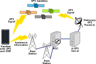
Assisted GNSS (A-GNSS) is a GNSS augmentation system that often significantly improves the startup performance—i.e., time-to-first-fix (TTFF)—of a global navigation satellite system (GNSS). A-GNSS works by providing the necessary data to the device via a radio network instead of the slow satellite link, essentially "warming up" the receiver for a fix. When applied to GPS, it is known as assisted GPS or augmented GPS. Other local names include A-GANSS for Galileo and A-Beidou for BeiDou.
Radiolocation, also known as radiolocating or radiopositioning, is the process of finding the location of something through the use of radio waves. It generally refers to passive, particularly radar—as well as detecting buried cables, water mains, and other public utilities. It is similar to radionavigation in which one actively seeks its own position; both are types of radiodetermination. Radiolocation is also used in real-time locating systems (RTLS) for tracking valuable assets.

Radio is the technology of communicating using radio waves. Radio waves are electromagnetic waves of frequency between 3 hertz (Hz) and 300 gigahertz (GHz). They are generated by an electronic device called a transmitter connected to an antenna which radiates oscillating electrical energy, often characterized as a wave. They can be received by other antennas connected to a radio receiver; this is the fundamental principle of radio communication. In addition to communication, radio is used for radar, radio navigation, remote control, remote sensing, and other applications.

A satellite navigation device or satnav device, also known as a satellite navigation receiver or satnav receiver or simply a GPS device, is a user equipment that uses satellites of the Global Positioning System (GPS) or similar global navigation satellite systems (GNSS). A satnav device can determine the user's geographic coordinates and may display the geographical position on a map and offer routing directions.
CDMA spectral efficiency refers to the system spectral efficiency in bit/s/Hz/site or Erlang/MHz/site that can be achieved in a certain CDMA based wireless communication system. CDMA techniques are characterized by a very low link spectral efficiency in (bit/s)/Hz as compared to non-spread spectrum systems, but a comparable system spectral efficiency.
GNSS enhancement refers to techniques used to improve the accuracy of positioning information provided by the Global Positioning System or other global navigation satellite systems in general, a network of satellites used for navigation. Enhancement methods of improving accuracy rely on external information being integrated into the calculation process. There are many such systems in place and they are generally named or described based on how the GPS sensor receives the information. Some systems transmit additional information about sources of error, others provide direct measurements of how much the signal was off in the past, while a third group provides additional navigational or vehicle information to be integrated into the calculation process.
References
- ↑ Milette, Greg; Stroud, Adam (2012-05-18). Professional Android Sensor Programming. John Wiley & Sons. p. 6. ISBN 9781118240458.
- ↑ Xu, Y.; Wang, K.; Pals, T.; Hadjichristos, A.; Sahota, K.; Persico, C. (1 September 2007). "A Low-IF CMOS Simultaneous GPS Receiver Integrated in a Multimode Transceiver". 2007 IEEE Custom Integrated Circuits Conference. pp. 107–110. doi:10.1109/CICC.2007.4405692. ISBN 978-1-4244-0786-6. S2CID 16237573.
- ↑ "Improving S-GPS sensitivity". Avago Technologies. Archived from the original on 2012-07-22.
| | This article about wireless technology is a stub. You can help Wikipedia by expanding it. |