Lancaster Regional Airport is two miles south of Lancaster, in Dallas County, Texas. Formerly Lancaster Airport, the National Plan of Integrated Airport Systems for 2011–2015 categorized it as a general aviation reliever airport.
Springdale Municipal Airport is a public use airport in Washington County, Arkansas, United States. It is owned by the City of Springdale and located one nautical mile (2 km) southeast of its central business district. This airport is included in the National Plan of Integrated Airport Systems for 2011–2015, which categorized it as a general aviation facility.

Amador County Airport, also known as Westover Field, is a county-owned public-use airport in Amador County, California, United States. It is located two nautical miles (3.7 km) northwest of the central business district of Jackson, California. The airport is mostly used for general aviation.

Baxter County Airport, is a county-owned public-use airport located four nautical miles northwest of the central business district of Mountain Home, a city in Baxter County, Arkansas, United States. It was known as Baxter County Airport until 2005. It changed its name back to Baxter County Airport due to confusion with the close proximity of Ozark, Arkansas and Ozark, Missouri, both of which have airports. The airport used to be served by Lone Star Airlines, which operated services to Dallas-Fort Worth International in the mid-1990s.
South Jersey Regional Airport is a public use airport in Lumberton Township, Burlington County, New Jersey, United States. Owned by the New Jersey Department of Transportation, the airport is located four nautical miles southwest of the central business district of Mount Holly, New Jersey. This facility is included in the National Plan of Integrated Airport Systems for 2011–2015, which categorized it as a general aviation reliever airport.
Mena Intermountain Municipal Airport is a city-owned, public-use airport located two nautical miles (4 km) southeast of the central business district of Mena, a city in Polk County, Arkansas, United States. It is included in the National Plan of Integrated Airport Systems for 2011–2015, which categorized it as a general aviation facility.

Crystal River Airport – Captain Tom Davis Field is a public airport located three miles (5 km) southeast of the central business district of Crystal River, in Citrus County, Florida, United States. It is owned by Citrus County.
Saline County Airport, also known as Watts Field, was a county-owned public-use airport located one mile (2 km) west of the central business district of Benton, a city in Saline County, Arkansas, United States. The airport's address was 401 Airline Drive in Benton.

Clinton Municipal Airport is a city-owned public-use airport located one nautical mile (2 km) northeast of the central business district of Clinton, a city in Van Buren County, Arkansas, United States.
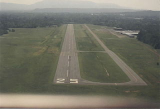
Winchester Regional Airport is three miles southeast of Winchester, in Frederick County, Virginia. It was recognized by the state as a licensed commercial airport in 1937 and was Winchester Municipal Airport until 1987.
Chester Catawba Regional Airport is a county-owned public-use airport located five nautical miles (9 km) north of the central business district of Chester, a city in Chester County, South Carolina, United States. It is technically a "regional" airport, but does not have a scheduled air service; it is mainly for the use of private aircraft for residents of Chester County. According to the FAA's National Plan of Integrated Airport Systems for 2009–2013, it is categorized as a general aviation facility.
Santee Cooper Regional Airport is a public use airport located seven nautical miles (13 km) south of the central business district of Manning, a city in Clarendon County, South Carolina, United States. It is owned by Clarendon County and began service in 1966. According to the FAA's National Plan of Integrated Airport Systems for 2009–2013, it is categorized as a general aviation facility.
Russellville Regional Airport is a city-owned public-use airport located two nautical miles (3.7 km) southeast of the central business district of Russellville, a city in Pope County, Arkansas, United States. According to the FAA's National Plan of Integrated Airport Systems for 2009–2013, it is categorized as a general aviation facility. It was formerly known as Russellville Municipal Airport.
Orange City Municipal Airport was a city-owned public-use airport located one nautical mile (1.85 km) south of the central business district of Orange City, a city in Sioux County, Iowa, United States. This airport was included in the FAA's National Plan of Integrated Airport Systems for 2009–2013, which categorized it as a general aviation facility.
Beech River Regional Airport is a public-use airport in Henderson County, Tennessee, United States. It is located five nautical miles northwest of the central business district of Parsons, a city in Decatur County.
Comanche County–City Airport is a public use airport located two nautical miles northeast of the central business district of Comanche, a city in Comanche County, Texas, United States. It is owned by the City of Comanche and Comanche County. The airport is included in the FAA's National Plan of Integrated Airport Systems for 2011–2015, which categorized it as a general aviation facility.
Kirk Field is a city-owned public-use airport located one nautical mile northwest of the central business district of Paragould, in Greene County, Arkansas, United States.
Heber Springs Municipal Airport is a public-use airport located 2 nautical miles (3.7 km) northeast of the central business district of Heber Springs, in Cleburne County, Arkansas, United States. It is owned by the City of Heber Springs.
Morrilton Municipal Airport is a public use airport located two nautical miles southeast of the central business district of Morrilton, in Conway County, Arkansas, United States. It is owned by the City of Morrilton.
Necedah Airport is a public use airport located one nautical mile (2 km) northwest of the central business district of Necedah, a village in Juneau County, Wisconsin, United States. It is owned by the Village of Necedah.


