
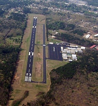
Texarkana Regional Airport, also known as Webb Field, is a public use airport located three nautical miles (6 km) northeast of the central business district of Texarkana, a city in Miller County, Arkansas, United States. It is owned by the Texarkana Airport Authority. The airport is located within the city limits of Texarkana, roughly 3 miles east of State Line Avenue. The front gate opens to the northwest, at the intersection of Arkansas Boulevard and U.S. Route 67. A Union Pacific Railroad line runs parallel to US 67 on the side of the highway facing the airport. It is mostly used for general aviation, but is also served by American Eagle with nonstop regional jet service to the American Airlines hub located at the Dallas/Fort Worth International Airport (DFW).
Springdale Municipal Airport is a public use airport in Washington County, Arkansas, United States. It is owned by the City of Springdale and located one nautical mile (2 km) southeast of its central business district. This airport is included in the National Plan of Integrated Airport Systems for 2011–2015, which categorized it as a general aviation facility.

Strother Field is a public airport in Cowley County, Kansas, six miles southwest of Winfield and north of Arkansas City. The airport is jointly owned by the two cities. The National Plan of Integrated Airport Systems for 2011–2015 categorized it as a general aviation facility.
Monticello Municipal Airport, also known as Ellis Field, is a public-use airport located two nautical miles east of the central business district of Monticello, in Drew County, Arkansas, United States. It is owned by the City of Monticello.

Marion County Regional Airport is a county-owned public-use airport in Marion County, Arkansas, United States. It is located one nautical mile north of the central business district of Flippin, Arkansas.

Clarksville Municipal Airport is a public-use airport located three nautical miles east of the central business district of Clarksville, in Johnson County, Arkansas, United States. It is owned by the City of Clarksville.

Carroll County Airport is a county-owned, public-use airport in Carroll County, Arkansas, United States. It is located three nautical miles (6 km) west of the central business district of Berryville, Arkansas. This airport is included in the National Plan of Integrated Airport Systems for 2011–2015, which categorized it as a general aviation facility.

Dexter B. Florence Memorial Field is a city-owned public-use airport located one nautical mile south of the central business district of Arkadelphia, a city in Clark County, Arkansas, United States.
Kirk Field is a city-owned public-use airport located one nautical mile northwest of the central business district of Paragould, in Greene County, Arkansas, United States.

Manila Municipal Airport is a public-use airport located two nautical miles northeast of the central business district of Manila, in Mississippi County, Arkansas, United States. It is owned by the City of Manila.

Blytheville Municipal Airport is a public use airport located three nautical miles east of the central business district of Blytheville, in Mississippi County, Arkansas, United States. It is owned by the City of Blytheville.

Batesville Regional Airport is a public-use airport located three nautical miles south of the central business district of Batesville, in Independence County, Arkansas, United States. It is owned by the City of Batesville.
Heber Springs Municipal Airport is a public-use airport located 2 nautical miles (3.7 km) northeast of the central business district of Heber Springs, in Cleburne County, Arkansas, United States. It is owned by the City of Heber Springs.
Morrilton Municipal Airport is a public use airport located two nautical miles southeast of the central business district of Morrilton, in Conway County, Arkansas, United States. It is owned by the City of Morrilton.
Melbourne Municipal Airport, also known as John E. Miller Field, is a city-owned, public-use airport located three nautical miles (6 km) east of the central business district of Melbourne, a city in Izard County, Arkansas, United States. It is included in the National Plan of Integrated Airport Systems for 2011–2015, which categorized it as a general aviation facility.
Warren Municipal Airport is a city-owned, public-use airport located three nautical miles (6 km) south of the central business district of Warren, a city in Bradley County, Arkansas, United States. It is included in the National Plan of Integrated Airport Systems for 2011–2015, which categorized it as a general aviation facility.
Osceola Municipal Airport is a city-owned, public-use airport located two nautical miles (4 km) southwest of the central business district of Osceola, a city in Mississippi County, Arkansas, United States. It is included in the National Plan of Integrated Airport Systems for 2011–2015, which categorized it as a general aviation facility.
Billy Free Municipal Airport is a public use airport in Desha County, Arkansas, United States. The airport is owned by the City of Dumas and located two nautical miles (4 km) west of its central business district. It is included in the National Plan of Integrated Airport Systems for 2011–2015, which categorized it as a general aviation facility.

Corning Municipal Airport is a city-owned, public-use airport located three nautical miles (6 km) west of the central business district of Corning, a city in Clay County, Arkansas, United States. It is included in the National Plan of Integrated Airport Systems for 2011–2015, which categorized it as a general aviation facility.

Marianna/Lee County Airport, also known as Steve Edwards Field, is a public use airport in Lee County, Arkansas, United States. It is owned by the City of Marianna and located three nautical miles (6 km) west of its central business district. This airport is included in the National Plan of Integrated Airport Systems for 2011–2015, which categorized it as a general aviation facility.


