
The Bay of Fundy is a bay between the Canadian provinces of New Brunswick and Nova Scotia, with a small portion touching the U.S. state of Maine. It is an arm of the Gulf of Maine. Its tidal range is the highest in the world. The name is probably a corruption of the French word fendu, meaning 'split'.
Truro is a town in central Nova Scotia, Canada. Truro is the shire town of Colchester County and is located on the south side of the Salmon River floodplain, close to the river's mouth at the eastern end of Cobequid Bay.

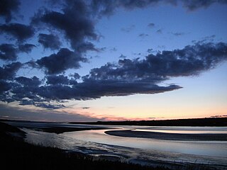
The Minas Basin is an inlet of the Bay of Fundy and a sub-basin of the Fundy Basin located in Nova Scotia, Canada. It is known for its extremely high tides.
Bass River is an unincorporated rural community in western Colchester County, north-central Nova Scotia, in the Maritimes of Canada. It is shares the name of the river located there, that flows into Cobequid Bay.
Upper Economy is a rural area of approximately 50 residents and 5 km2 located along Trunk 2 in western Colchester County, Nova Scotia. It stretches from along the north shoreline of the western end of Cobequid Bay north into the lower slopes of the Cobequid Mountains. Upper Economy is considered locally to be part of the rural community of Economy. It borders Little Bass River to the west and the former community of Pleasant Hills to the north.

The Musquodoboit River is a Canadian river located in central Nova Scotia in the northeastern part of Halifax Regional Municipality. The river is approximately 97 kilometres (60 mi) in length with roughly 88 kilometres (55 mi) being traversable by paddle. It has a watershed area of 1,409 square kilometres (544 sq mi)

The Shubenacadie River is a river in Nova Scotia, Canada. It has a meander length of approximately 72 km from its source at Shubenacadie Grand Lake to its mouth at the historic seaport village of Maitland on Cobequid Bay, site of the building of the William D. Lawrence, the largest wooden ship ever built in Canada. In 2009, the I Backpack Canada blog named the Shubenacadie one of the top five whitewater rivers in Canada. The lower 30 km of the river is tidal and the river experiences a tidal bore twice daily, with some bores reaching up to 3 m in height at certain points along the river. Local tourism operators offer adventure seekers a chance to ride with the bore on high-horse power Zodiac Hurricanes. Tidal Bore Rafting was invented at the Tidal Bore Rafting Resort by H. Knoll. It is also a popular surfing spot for experienced Sea Kayakers.
The Shubenacadie Valley is a Canadian rural region in central Nova Scotia.

Trunk 2 is part of the Canadian province of Nova Scotia's system of Trunk Highways. The route runs from Halifax to Fort Lawrence on the New Brunswick border. Until the 1960s, Trunk 2 was the Halifax area's most important highway link to other provinces, and was part of a longer Interprovincial Highway 2 which ended in Windsor, Ontario. The controlled access Highway 102 and Highway 104 now carry most arterial traffic in the area, while Trunk 2 serves regional and local traffic.
The Fundy Shore Ecotour is a former scenic drive and network of tourist destinations in the Canadian province of Nova Scotia and encircles several sub-basins of the Bay of Fundy, which contains the highest tidal range on the planet.
The Wentworth Valley is a valley in the Cobequid Mountains of northwestern Nova Scotia, Canada. It comprises the lowest elevation pass through the Cobequids. It was named after the colonial governor John Wentworth (1792-1808).

The Nova Scotia peninsula is a peninsula on the Atlantic coast of North America.
Manganese Mines is an unincorporated community in Colchester County, Nova Scotia, Canada.

Burntcoat Head is an unincorporated rural Canadian community in Hants County, Nova Scotia. The area is known for having the largest tidal range of any location in the world.

The Cobequid Mountains, also sometimes referred to as the Cobequid Hills, is a Canadian mountain range located in Nova Scotia in the mainland portion of the province.

Masstown, formerly Cobequid, is a farming community located approximately 17 kilometres (11 mi) from Truro, Nova Scotia.
Beaver Brook is a small community in the Canadian province of Nova Scotia, located in Colchester County. It is a mainly rural community with one small saw mill. Beaver Brook is located on the 236 Highway just west of the community of Old Barns. The "Beaver Brook" runs through the community's farm fields and finally into the Cobequid Bay at the headwaters of the Bay of Fundy.

The old name Cobequid was derived from the Mi'kmaq word "Wagobagitk" meaning "the bay runs far up", in reference to the area surrounding the easternmost inlet of the Minas Basin in Nova Scotia, Canada, a body of water called Cobequid Bay.

Fort Ellis was a British fort or blockhouse built during the French and Indian War, located at the junction of the Shubenacadie and Stewiacke Rivers, close to Stewiacke, Nova Scotia, Canada. The location was labelled Ville Pierre Hebert by Charles Morris. The 14 Acadian families in the area vacated with the Acadian Exodus. Charles Morris recommended a Fort on the Shubenacadie River in 1753. Governor Lawrence first considered the fort in 1754 as a means to protect Halifax from Mi'kmaq raids. Lawrence decided the fort would not be effective until after the Battle of Fort Beauséjour. The fort was completed on October 18, 1761, shortly after the Halifax Treaties were signed. The fort was to guard the new road built to connect Truro and Halifax against Mi'kmaq raids. The fort was called Fort Ellis after Governor Henry Ellis, who was appointed governor weeks after the forts completion. The fort was never garrisoned and eventually abandoned in 1767. Fort Belcher, named after Governor Jonathan Belcher, was built on Salmon River in Lower Onslow, Nova Scotia (1761–67). Fort Franklin was built at Tatamagouche in 1768, named after Michael Francklin and lasted only a year. Fort Morris was named after Charles Morris.
