Eastern Shore (Nova Scotia)

Last updated
Eastern Shore
Seaside festival 058.JPG
CountryCanada
ProvinceFlag of Nova Scotia.svg  Nova Scotia
Time zone UTC-4 (AST)
  Summer (DST) UTC-3 (ADT)
Area code(s) 782, 902

The Eastern Shore is a region of the Canadian province of Nova Scotia. It is the Atlantic coast running northeast from Halifax Harbour to the eastern end of the peninsula at the Strait of Canso.

Contents

History

Canso, along with Annapolis Royal, Halifax, and Lunenburg, are some of North America's earliest settlements. The Battle at Jeddore (1722) is one of the many historic events to occur along the shore.

A railway had been proposed during the 1880s to run east from Dartmouth, however the sparse settlement and lack of industrial economic activity saw the railway line swing north up the Musquodoboit River at Musquodoboit Harbour to access the fertile agricultural district of the Musquodoboit Valley. Another railway project was proposed to run between Pictou and the village of Guysborough and on to Canso during the age of sail, when Can-so rivalled Halifax as the most important first port of call in Nova Scotia for westbound trans-Atlantic vessels, as Canso was roughly the same distance by rail from the New Brunswick–Nova Scotia border as Halifax. A rail line was eventually graded and bridges constructed between Pictou and Guysborough during the 1930s, however, tracks were never laid and the project was abandoned, leaving most of the Eastern Shore without rail service.

During the post-World War II period, the provincial government upgraded local roads, that resulted in the present alignment of Trunk 7.

During the 1980s-90s, when the rail line was abandoned, the controlled-access Nova Scotia Highway 107 was built from the Burnside Industrial Park in Dartmouth to Musquodoboit Harbour, to assist commuters and truck-traffic that travels to rural Municipal Halifax and to Highway 102 via Highway 118.

A 1990s regional development project saw the port of Sheet Harbour redeveloped into an important regional deep-water port. The facility is most heavily used during the winter months, when the Northumberland Strait port of Pictou is iced-in and industrial shippers from Pictou County truck shipments to Sheet Harbour. A large industrial greenhouse, sawmill operation, and wharf, are also located on site. [1] Beaver Harbour was home to a trans-Atlantic cable station which was operated by Teleglobe, but is now decommissioned. [2]

Geography

A map of east and west Eastern Shore planning areas in Halifax, Nova Scotia Novascotiahrm-easternshore.png
A map of east and west Eastern Shore planning areas in Halifax, Nova Scotia

Most of the Eastern Shore of Nova Scotia consists of sandstone and shale bedrock, forming rolling hills, which are up to 75 metres (246 ft) in elevation and many offshore islands, of which two of the largest are Wolfes Island and Barren Island. [3] [4] [5] The Eastern Shore is heavily forested. Approximately 12 kilometres (7.5 mi) inland from the coast is the Eastern Shore Granite Ridge. This is an expansive area of 350-million-year-old granite bedrock. [6]

Waterways

Several major rivers flow into the coast along the Eastern Shore, including the Musquodoboit River, [7] which flows into the Musquodoboit Harbour, [8] Jeddore Harbour, [9] Tangier River, [10] which flows from Tangier Grand Lake to the Atlantic, [11] West River Sheet Harbour, which flows into the Northwest Arm of Sheet Harbour, as well as East River Sheet Harbour into the Northeast Arm. [12] [13] [14] [15] The St. Mary's River also flows into the Atlantic, passing through the community of Sherbrooke. [16] There are many lakes, ponds, flowages and other types of freshwater bodies along the Eastern Shore. The largest of which are Porters Lake, [17] which flows almost directly into the Atlantic Ocean, Lake Charlotte, [18] which flows into Ship Harbour via the Ship Harbour River [19] [20] and Tangier Grand Lake, [10] which flows into the Atlantic Ocean via the Tangier River. [11]

The largest water formation by far is the Chedabucto Bay, at the eastern end of the Eastern Shore. [21] There also numerous, albeit much smaller, bays, harbours and other coastal features along the Eastern Shore, including but not limited to: Musquodoboit Harbour, [8] Jeddore Harbour, [9] Ship Harbour, [19] Sheet Harbour, [12] [13] Country Harbour, [22] Tor Bay [23] and Guysborough Harbour. [24]

The Eastern Shore is a scenic, yet sparsely settled area, hosting dozens of small fishing harbours and communities; in recent decades the region has become home to a growing number of cottages and recreational properties, given the number of unspoiled sandy beaches and dramatic coastlines. The shore also hosts the majority of Nova Scotia's small islands. The tourism industry is concentrated near popular beaches and provincial parks such as Lawrencetown, Clam Harbour, and Martinique, as well as the centrally-located service communities of Musquodoboit Harbour, Sheet Harbour, Sherbrooke, Canso, Guysborough and Mulgrave. Popular tourist attractions include the Liscombe Lodge resort and conference centre in Liscomb Mills and the Historic Sherbrooke Village in Sherbrooke. [25] [26]

Demographics

The area between Cape Breton-and-Dartmouth is sparsely populated, however, there are more than 300 communities along the Eastern Shore, which vary in size. [27]

The decline in the fishing industry has meant an outflow of people to larger urban areas and other fishing villages in the province. [27] Guysborough and Canso, with populations of 922 and 820 respectively, are the largest communities.

Communities

Although these are not all of the communities in the Eastern Shore, these are some of the most populated.

Municipalities

Economy

Most of the economy along the Eastern Shore is based around fishing, forestry and tourism, with an industrial port in Sheet Harbour as well. [1]

Numerous lumber mills operated here during the early 1900s as Nova Scotia entered the industrial revolution.

Tourism

Tourism is becoming an increasingly active industry along the Eastern Shore.

Duncan MacMillan High School Duncan MacMillan High School.jpg
Duncan MacMillan High School
Sherbrooke Village Sherbrooke Village Nova Scotia1.jpg
Sherbrooke Village

There is a Fisherman's Life Museum in Jeddore Oyster Ponds. [28] There is trout fishing and Atlantic salmon serves as a sport in rivers along the coast. In Eastern Passage, there is a Fishermen's Cove tourist attraction with a few stores. [29] There is an interactive museum located in Sherbrooke, Nova Scotia. It is called the Historic Sherbrooke Village and it depicts life around the 1900s in the village. [25] The longest beaches on the Eastern Shore are Lawrencetown Beach, in Lawrencetown, [30] Martinique Beach, near Musquodoboit Harbour [31] and Taylor Head Beach, located in Spry Bay, within the boundaries of Taylor Head Provincial Park. [32]

Transportation

Roads

Education

All schools within the Eastern Shore, except St. Mary's Education Centre, are administered by the Halifax Regional Centre for Education. St. Mary's Education Centre is administered by the Strait Regional School Board.

Elementary Schools

High Schools

Junior High Schools

There are nine schools along the Eastern Shore. Most are located in the larger communities. and Saint Mary's Education Centre/Academy (SMECA), in Sherbrooke. [40]

A new school in Sheet Harbour is currently being built in the former site of Duncan MacMillan High School and Sheet Harbour Consolidated School. It is a merge of the schools Duncan MacMillan High School, Sheet Harbour Consolidated School, Lakefront Consolidated Elementary and Eastern Consolidated School.There is a possibility that both schools in Sheet Harbour, as well as Lakefront Consolidated School in Tangier, will be closed and merged into one P-12 school in the next few years. [41]

Related Research Articles

<span class="mw-page-title-main">Central Nova</span> Federal electoral district in Nova Scotia, Canada

Central Nova is a federal electoral district in Nova Scotia, Canada that was represented in the House of Commons of Canada from 1968 until 1996. In 1996, Antigonish County and part of Guysborough County were placed with Pictou County in a new electoral boundaries configuration to form the electoral district of Pictou-Antigonish-Guysborough. A new version of Central Nova was established in 2003 and — in conjunction with the Pictou-Antigonish-Guysborough iteration — represented a significant electoral boundaries change with specific reference to Antigonish County. Between 1867 and 1997, Antigonish County was not in a riding that included Pictou County; rather, it comprised either its own electoral district (Antigonish), or part of other districts shared with Eastern Nova Scotia (Antigonish-Guysborough) and Cape Breton Island communities. In 2013, part of Antigonish County was "placed back" with communities in the electoral district of Cape Breton Canso, a riding which had emerged in part from the former Cape Breton Highlands Canso riding in 1996. The current version of Central Nova includes Pictou County, parts of Antigonish and Guysborough Counties and extends into Halifax Regional Municipality.

<span class="mw-page-title-main">Halifax, Nova Scotia</span> Capital and most populous municipality of Nova Scotia, Canada

Halifax is the capital and largest municipality of the Canadian province of Nova Scotia, and the largest municipality in Atlantic Canada. As of 2022, it is estimated that the population of the Halifax CMA was 480,582, with 348,634 people in its urban area. The regional municipality consists of four former municipalities that were amalgamated in 1996: Halifax, Dartmouth, Bedford, and Halifax County.

The Halifax Regional Municipality (HRM) in Nova Scotia, Canada has a widely varied geography.

<span class="mw-page-title-main">Musquodoboit Valley</span> Valley in Nova Scotia, Canada

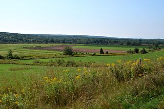
The Musquodoboit Valley is a valley and region in the Halifax Regional Municipality of Nova Scotia, Canada. It is administratively located in the municipality's Musquodoboit Valley & Dutch Settlement planning area and the western edge of the valley includes communities that are considered part of the commutershed for the urban area of the Halifax Regional Municipality. The picturesque Musquodoboit River flows through majority of the valley, passing by most of the communities in the valley. The river is approximately 97 kilometres (60 mi) long and originates in the extreme northeastern area of the valley. The three largest communities in the valley are Upper Musquodoboit, Middle Musquodoboit and Musquodoboit Harbour. The word "Musquodoboit" is derived from the Mi’kmaq language and means "rolling out in foam".

Area codes 902 and 782 are telephone area codes in the North American Numbering Plan (NANP) for the Canadian provinces of Nova Scotia and Prince Edward Island. Area code 902 was one of the nine original North American area codes in Canada established in October 1947. Area code 782 was added to the numbering plan area in August 2014, to form an overlay complex in relief to prevent telephone number shortages.

<span class="mw-page-title-main">Nova Scotia Trunk 7</span> Highway in Nova Scotia

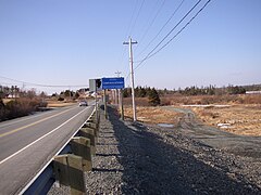
Nova Scotia Trunk 7 is part of the Canadian province of Nova Scotia's system of Trunk Highways. The route runs from Bedford to Antigonish, along the Eastern Shore for a distance of 269 kilometres (167 mi). Part of Trunk 7 is known as the Marine Drive.

The Marine Drive is a designated scenic route along Nova Scotia's Eastern Shore. It closely follows the coast of the Atlantic Ocean and the Strait of Canso from the Canso Causeway to the junction of Route 322 and Highway 111 in Dartmouth.

<span class="mw-page-title-main">Sheet Harbour, Nova Scotia</span> Place in Nova Scotia, Canada

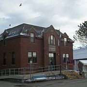
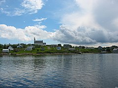
Sheet Harbour is a rural community in Nova Scotia, Canada. It is located in the eastern reaches of the Halifax Regional Municipality, approximately 117 km (73 mi) northeast of the central urban area of the municipality, concentrated on Downtown Halifax and Dartmouth. The community is located along the Marine Drive scenic route on Trunk 7 at its junctions with Route 224 and Route 374. Surrounding the branched harbour which its name is derived from, the community has a population of about 800 and its respective census tract, containing sizable amounts of land around the community, has a population of 3,478 as of the 2011 Census. Two rivers, West River and East River, flow through the community and into the Northwest and Northeast Arms of the harbour respectively. The coastline of the community is heavily eroded and the region in which the community is located has an abundance of lakes. The region has a humid continental climate, congruent with the majority of Nova Scotia, and the ocean significantly influences the temperature.

<span class="mw-page-title-main">Moser River, Nova Scotia</span> Place in Nova Scotia, Canada

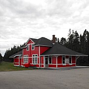
Moser River is a rural community on the Eastern Shore of Nova Scotia, Canada, in the Halifax Regional Municipality. The community lies along the Marine Drive on Trunk 7, 32 km (20 mi) east of Sheet Harbour and 51 km (32 mi) southwest of Sherbrooke. The community is located along the shores of Necum Teuch Harbour, an inlet of the Atlantic Ocean, and is at the mouth of Moser River. The area was called Noogoomkeak in the mi'kmaq language, translating to "soft sand place". The community is named for Henry Moser, who was the son of Jacob Moser, who settled the area in the early 1800s. The first school in the community was built in 1905, and another school, Moser River Consolidated School, was built in 1957. The school closed in 2015, due to its very low student population. Marine Drive Academy in Sheet Harbour serves the community and its surroundings at all grade levels. There is a small seaside park in the community near the former school, as well as a post office and convenience store.

<span class="mw-page-title-main">Musquodoboit Harbour, Nova Scotia</span> Place in Nova Scotia, Canada

Musquodoboit Harbour is a rural community located in Nova Scotia, Canada within the Halifax Regional Municipality. The community is situated on the Eastern Shore at the mouth of the Musquodoboit River. The community lies 45 kilometres east of downtown Halifax. With a hospital, RCMP detachment, postal outlet, schools, recreational center, library, municipal office and other services, Musquodoboit Harbour is a serve centre for many of the surrounding communities.

<span class="mw-page-title-main">Geography of Nova Scotia</span>

Nova Scotia is a province located in Eastern Canada fronting the Atlantic Ocean. One of the Maritime Provinces, Nova Scotia's geography is complex, despite its relatively small size in comparison to other Canadian provinces.

<span class="mw-page-title-main">Jeddore, Nova Scotia</span> Unincorporated community in Nova Scotia, Canada

Jeddore is a Canadian rural community in Nova Scotia's Halifax Regional Municipality. The community itself comprises several smaller communities. Often the inner communities are referred to on their own but much of the time simply the encapsulating region of Jeddore is simply used. This is most likely due to the size of the communities, individually they are relatively unknown to residents outside of Nova Scotia's Eastern Shore.

<span class="mw-page-title-main">Outline of Nova Scotia</span> Overview of and topical guide to Nova Scotia

The following outline is provided as an overview of and topical guide to Nova Scotia:

<span class="mw-page-title-main">Gold mining in Nova Scotia</span>

Gold mining has been a part of Nova Scotia's heritage for 150 plus years and continues to this day. Over a million ounces of gold have been produced in the province since mining began in 1861. Although not as well known as the gold rushes of California, the Klondike, Australia, and South Africa, three distinct rushes resulted in an economic boom in the province and saw the birth and sometimes demise of many new communities.

East River Sheet Harbour is a river on the Eastern Shore of Nova Scotia, Canada, in the Halifax Regional Municipality. Its headwaters are at the Marshall Flowage near Malay Falls and the mouth of the river is at the head of the Northeast Arm in Sheet Harbour, Nova Scotia.

<span class="mw-page-title-main">Eastern Shore Granite Ridge</span> Mountain ridge in Nova Scotia, Canada

The Eastern Shore Granite Ridge, also known as the Musquodoboit Batholith, is a range of prominent hills averaging 100-125m (330-410ft) in height, located just inland from the Eastern Shore of Nova Scotia. Geologically, it is related to the much larger South Mountain Batholith, but the two are geologically distinct areas. Many of the hills have steep cliffs on one or more of their sides, some featuring vertical drops in excess of 50m (160ft); as a result, many of the taller hills offer extensive views despite their relatively low elevation.

<span class="mw-page-title-main">Tourism on the Eastern Shore (Nova Scotia)</span>

The Eastern Shore is a tourism region of the province of Nova Scotia, Canada. It provides two percent of the revenue for the province's tourism economy. One of its key features is an archipelago known as the 100 Wild Islands area.

References

  1. 1 2 "Port of Sheet Harbour & Industrial Park". Nova Scotia Business Inc. Archived from the original on 2015-09-29. Retrieved 18 August 2015.
  2. "Business Development". Sheet Harbour Chamber of Commerce. Retrieved 30 May 2015.
  3. "Wolfes Island". Natural Resources Canada. Retrieved 3 November 2016.
  4. "Barren Island". Natural Resources Canada. Retrieved 3 November 2016.
  5. "Geological Map of the Province of Nova Scotia | novascotia.ca".
  6. "Tangier Grand Lake Wilderness Area". Province of Nova Scotia. 31 March 2014. Retrieved 3 February 2016.
  7. "Musquodoboit River". Natural Resources Canada. Retrieved 5 June 2016.
  8. 1 2 "Musquodoboit Harbour". Natural Resources Canada. Retrieved 5 June 2016.
  9. 1 2 "Jeddore Harbour". Natural Resources Canada. Retrieved 5 June 2016.
  10. 1 2 "Tangier Grand Lake". Natural Resources Canada. Retrieved 5 June 2016.
  11. 1 2 "Tangier River". Natural Resources Canada. Retrieved 5 June 2016.
  12. 1 2 "Northwest Arm". Natural Resources Canada. Retrieved 5 June 2016.
  13. 1 2 "Northeast Arm". Natural Resources Canada. Retrieved 5 June 2016.
  14. "West River Sheet Harbour". Natural Resources Canada. Retrieved 5 June 2016.
  15. "East River Sheet Harbour". Natural Resources Canada. Retrieved 5 June 2016.
  16. "St. Marys River". Natural Resources Canada. Retrieved 5 June 2016.
  17. "Porters Lake". Natural Resources Canada. Retrieved 5 June 2016.
  18. "Lake Charlotte". Natural Resources Canada. Retrieved 5 June 2016.
  19. 1 2 "Ship Harbour". Natural Resources Canada. Retrieved 5 June 2016.
  20. "Ship Harbour River". Natural Resources Canada. Retrieved 5 June 2016.
  21. "Chedabucto Bay". Natural Resources Canada. Retrieved 5 June 2016.
  22. "Country Harbour". Natural Resources Canada. Retrieved 5 June 2016.
  23. "Tor Bay". Natural Resources Canada. Retrieved 5 June 2016.
  24. "Guysborough Harbour". Natural Resources Canada. Retrieved 5 June 2016.
  25. 1 2 "Sherbrooke Village". Nova Scotia Communities, Culture and Heritage. Retrieved 3 February 2016.
  26. "LISCOMBE LODGE RESORT & CONFERENCE CENTRE". NOVASCOTIA.COM. Retrieved 5 June 2016.
  27. 1 2 "Eastern shore Geography". Archived from the original on 2004-02-03. Retrieved 2006-11-04.
  28. "Fisherman's Life Museum". Nova Scotia Communities, Culture and Heritage. Retrieved 3 February 2016.
  29. "Fisherman's Cove". Fisherman's Cove. Retrieved 3 February 2016.
  30. "LAWRENCETOWN BEACH PROVINCIAL PARK". NOVASCOTIA.COM. Retrieved 3 February 2016.
  31. "MARTINIQUE BEACH PROVINCIAL PARK". NOVASCOTIA.COM. Retrieved 3 February 2016.
  32. "Day Use Parks — listed A-Z". Nova Scotia Government. Archived from the original on 2016-01-12. Retrieved 14 November 2015.
  33. "O'Connell Drive Elementary". Halifax Regional School Board. Retrieved 8 February 2016.
  34. "Porters Lake Elementary". Halifax Regional School Board. Retrieved 8 February 2016.
  35. "Sheet Harbour Consolidated Elementary". Halifax Regional School Board. Archived from the original on 2016-02-15. Retrieved 8 February 2016.
  36. "Duncan MacMillan High". Halifax Regional School Board. Archived from the original on 15 February 2016. Retrieved 8 February 2016.
  37. "Eastern Shore District High". Halifax Regional School Board. Retrieved 8 February 2016.
  38. "Gaets Brook Junior High". Halifax Regional School Board. Retrieved 8 February 2016.
  39. "Oyster Pond Academy". Halifax Regional School Board. Retrieved 8 February 2016.
  40. "Our School". Saint Mary's Education Centre/Academy. Retrieved 8 November 2015.
  41. "School Review Committee Response - Sheet Harbour Consolidated Elementary - January 2013" (PDF). Halifax Regional School Board. Retrieved 3 February 2015.

44°55′N62°20′W / 44.917°N 62.333°W / 44.917; -62.333