San Antonio Springs

Last updated
San Antonio Springs
TXMap-doton-SanAntonio.PNG
Location of San Antonio Springs
Location San Antonio, Texas, USA
Coordinates 29°28′08″N98°28′03″W / 29.468889°N 98.467500°W / 29.468889; -98.467500 Coordinates: 29°28′08″N98°28′03″W / 29.468889°N 98.467500°W / 29.468889; -98.467500
Spring source Edwards Aquifer
Elevation680 feet (210 m) above sea level
TypeKarst springs
Provides water for San Antonio River
Magnitude 2
Discharge20 cubic feet (570 l)/s

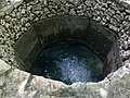
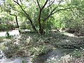
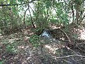
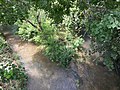
San Antonio Springs (also known as the Blue Hole) is a cluster of springs in Bexar County, Texas. These springs provide a large portion of the water for the San Antonio River, which flows from San Antonio to the Gulf of Mexico. The San Pedro Springs also feed into the San Antonio River.

Contents

Geography

The San Antonio Springs are located about three miles (5 km) north of Downtown San Antonio; most are now on the property of the University of the Incarnate Word in the Midtown Brackenridge district of San Antonio. The springs are fed by water from the Edwards Aquifer; this water reaches the surface through faults along the Balcones Escarpment. There have been more than 100 individual springs identified, but many of these are no longer active due to pumping demands on the Edwards Aquifer and sedimentation from the upstream Olmos Creek, although sedimentation has been partially mitigated by the Olmos Dam since 1926. [1] During periods of drought, the springs sometimes stop flowing entirely, only to resume when water levels rise in the aquifer. The mean flow from the springs is 20 ft³/s (0.6 m³/s).

History

Artifacts from Paleo-Indian cultures have been found at the site of the San Antonio Springs; some of these artifacts are more than 11,000 years old. [2]

The earliest Europeans found up to 200 sub-bands of Coahuiltecan Indians in the vicinity of the springs; however, they were soon displaced by the Lipan Apaches. Spanish missionaries built a system of aqueducts and canals to carry water from the springs to the local missions, including The Alamo. [2] [3]

By the Civil War, the springs had become contaminated. [3] In 1891, artesian wells were drilled to provide clean water for the city. [3]

Related Research Articles

Travis County, Texas County in Texas, United States

Travis County is located in south central Texas. As of the 2020 census, the population was 1,290,188. It is the fifth-most populous county in Texas. Its county seat is Austin, the capital of Texas. The county was established in 1840 and is named in honor of William Barret Travis, the commander of the Republic of Texas forces at the Battle of the Alamo. Travis County is part of the Austin–Round Rock-Georgetown Metropolitan Statistical Area. It is located along the Balcones Fault, the boundary between the Edwards Plateau to the west and the Blackland Prairie to the east.

Barton Springs United States historic place

Barton Springs is a set of four natural water springs located at Barton Creek on the grounds of Zilker Park in Austin, Texas, resulting from water flowing through the Edwards Aquifer. The largest spring, Main Barton Spring supplies water to Barton Springs Pool, a popular recreational destination in Austin. The smaller springs are located nearby, two with man-made structures built to contain and direct their flow. The springs are the only known habitat of the Barton Springs Salamander, an endangered species.

Edwards Plateau Geographic and ecological region of Texas, United States

The Edwards Plateau is a geographic region at the crossroads of Central, South, and West Texas. It is bounded by the Balcones Fault to the south and east, the Llano Uplift and the Llano Estacado to the north, and the Pecos River and Chihuahuan Desert to the west. San Angelo, Austin, San Antonio, and Del Rio roughly outline the area. The southeast portion of the plateau is known as the Texas Hill Country.

Ichetucknee River River in Florida, United States

The Ichetucknee River is a spring-fed, pristine river in North Central Florida. The entire 6 miles (9.7 km) of the river average 20 feet (6.1 m) wide, 5 feet (1.5 m) deep and most of the 6 miles lie within the boundaries of the Ichetucknee Springs State Park while the rest is to the south of US Highway 27. Three Rivers Estates Property Owners (TREPO) is the property owner association that manages the area along the private side of the river as it travels and flows into the Santa Fe River.

Guadalupe River (Texas) River in Texas

The Guadalupe River, runs from Kerr County, Texas, to San Antonio Bay on the Gulf of Mexico, with an average temperature of 17.75 degrees Celsius. It is a popular destination for rafting, fly fishing, and canoeing. Larger cities along it include Kerrville, New Braunfels, Seguin, Gonzales, Cuero, and Victoria. It has several dams along its length, the most notable of which, Canyon Dam, forms Canyon Lake northwest of New Braunfels.

Barton Creek River in the United States of America

Barton Creek is a tributary that feeds the Colorado River as it flows through the Texas Hill Country. The creek passes through some of the more scenic areas in Greater Austin, surrounded in many parts by a greenbelt of protected lands that serves as a habitat for many indigenous species of flora and fauna. The creek passes through Barton Creek Greenbelt and is fed by Barton Springs.

Meadows Center for Water and the Environment

The Meadows Center for Water and the Environment, formerly Aquarena Springs and later the Aquarena Center, is an educational center in San Marcos, Texas, that seeks to preserve the unique archeological and biological resources of Spring Lake. Formed from more than 200 artesian springs, this lake is one of the world's largest aquifer fed system. A state antiquities landmark, this site is also believed to be one of the longest continuously inhabited places in North America.

San Marcos River

The San Marcos River rises from the San Marcos Springs, the location of Aquarena Springs, in San Marcos, Texas. The springs are home to several threatened or endangered species, including the Texas blind salamander, fountain darter, and Texas wild rice. The river is a popular recreational area, and is frequented for tubing, canoeing, swimming, and fishing.

Edwards Aquifer Source of drinking water in Texas

The Edwards Aquifer is one of the most prolific artesian aquifers in the world. Located on the eastern edge of the Edwards Plateau in the U.S. state of Texas, it is the source of drinking water for two million people, and is the primary water supply for agriculture and industry in the aquifer's region. Additionally, the Edwards Aquifer feeds the Comal and San Marcos springs, provides springflow for recreational and downstream uses in the Nueces, San Antonio, Guadalupe, and San Marcos river basins, and is home to several unique and endangered species.

Little River (Texas)

The Little River is a river in Central Texas in the Brazos River watershed. It is formed by the confluence of the Leon River and the Lampasas River near Little River, Texas in Bell County. It flows generally southeast for 75 miles (121 km) until it empties into the Brazos River about 5 miles (8.0 km) southwest of Hearne, at a site called Port Sullivan in Milam County. The Little River has a third tributary, the San Gabriel River, which joins the Little about 8 miles (13 km) north of Rockdale and five miles southwest of Cameron. Cameron, the county seat of Milam County and the only city of any significant size on the Little River, was established in 1846.

Cibolo Creek Stream in South Central Texas

Cibolo Creek is a stream in South Central Texas that runs approximately 96 miles (154 km) from its source at Turkey Knob near Boerne, Texas, to its confluence with the San Antonio River in Karnes County. The creek is a tributary of the San Antonio River, at the easternmost part of its watershed.

Save Our Springs Alliance (SOS), originally called the Save Our Springs Legal Defense Fund, was a nonprofit corporation created to protect the citizen-drafted SOS Ordinance of 1992 to conserve Barton Springs in Austin, Texas. The ordinance was written by citizens in reaction to the city's "Composite Ordinance," which citizens regarded as insufficient to save Barton Springs.

San Saba River

The San Saba River is a river in the U.S. state of Texas. It is an undeveloped and scenic waterway located on the northern boundary of the Edwards Plateau.

San Marcos Springs

San Marcos Springs is the second largest natural cluster of springs in Texas. The springs are located in the city of San Marcos, Texas, about 30 miles (48 km) southwest of Austin and 46 miles (74 km) northeast of San Antonio.

San Pedro Springs

San Pedro Springs is the name of a cluster of springs in Bexar County, Texas, U.S.A. These springs provide water for San Pedro Creek, which flows into the San Antonio River. The San Antonio Springs also feed into the San Antonio River.

Salado Creek

Salado Creek is a waterway in San Antonio that runs from northern Bexar County for about 38 miles (61 km) to the San Antonio River near Buena Vista.

The San Antonio–El Paso Road, also known as the Lower Emigrant Road or Military Road, was an economically important trade route between the Texas cities of San Antonio and El Paso between 1849 and 1882. Mail, freight, and passengers traveled by horse and wagon along this road across the Edwards Plateau and dangerous Trans-Pecos region of West Texas.

San Antonio Conservation Society Nonprofit organization in Texas, U.S.

The Conservation Society of San Antonio is located in the Bexar County city of San Antonio in the U.S. state of Texas. Founding members were Emily Edwards, who became the organization's first president, and Rena Maverick Green. The organization was formed on March 22, 1924, and officially incorporated on July 8, 1925. The Society is currently headquartered in the Anton Wulff House, which they saved from destruction in 1974. The home was built 1869–1870 by German immigrant Anton Wulff, who became the city's first Park Commissioner.

Brackenridge Park Golf Course

Brackenridge Park Golf Course is a historic golf course in San Antonio, Texas and the oldest 18-hole public golf course in Texas. It opened for play in 1916 and was the first inductee into the Texas Golf Hall of Fame. Brackenridge Park was the original site of the Texas Open which held the tournament for most years between 1922-1959. Located in historic Brackenridge Park, the course is one of six municipal golf courses managed by the non-profit management group, the Alamo City Golf Trail. The Alamo City Golf Trail consists of Brackenridge Park Golf Course, Cedar Creek Golf Course, Mission del Lago Golf Course, Olmos Basin Golf Course, Riverside Golf Course, San Pedro Driving Range and Par 3, and Willow Springs Golf Course.

Comanche Springs (Texas)

Comanche Springs was an aquifer of six artesian springs geographically located between the Edwards Plateau and the Trans-Pecos regions of West Texas. The groundwater source originated from a Comanchean limestone fault combined within the bountiful Edwards Aquifer and the Glass Mountains.

References

  1. Brune, G.M. (2002). Springs of Texas. Manufacturing engineering modular series. Texas A&M University Press. p. 70. ISBN   978-1-58544-196-9 . Retrieved 2021-11-08.
  2. 1 2 "San Antonio Springs". Texas State Historical Association, Handbook of Texas. 1995-04-01. Retrieved 2021-11-08.
  3. 1 2 3 "San Antonio Springs and Brackenridge Park". The Edwards Aquifer Website. Retrieved 2021-11-08.