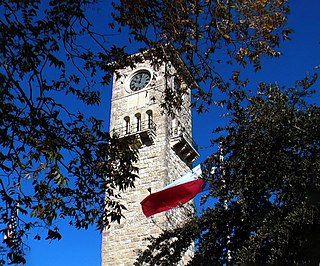
Fort Sam Houston is a U.S. Army post in San Antonio, Texas. Known colloquially as "Fort Sam," it is named for the U.S. Senator from Texas, U.S. Representative from Tennessee, Tennessee and Texas governor, and first president of the Republic of Texas, Sam Houston.

Gateway National Recreation Area is a 26,607-acre (10,767 ha) U.S. National Recreation Area in New York City and Monmouth County, New Jersey. It provides recreational opportunities that are not commonly found in a dense urban environment, including ocean swimming, bird watching, boating, hiking and camping. More than 8.7 million people visited Gateway National Recreation Area in 2022, making it the fourth-most visited unit of the National Park Service.

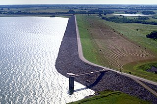
Lake Texoma is one of the largest reservoirs in the United States, the 12th-largest US Army Corps of Engineers' (USACE) lake, and the largest in USACE Tulsa District. Lake Texoma is formed by Denison Dam on the Red River in Bryan County, Oklahoma, and Grayson County, Texas, about 726 miles (1,168 km) upstream from the mouth of the river. It is located at the confluence of the Red and Washita Rivers. The project was completed in 1944. The damsite is about 5 miles (8.0 km) northwest of Denison, Texas, and 15 miles (24 km) southwest of Durant, Oklahoma. Lake Texoma is the most developed and most popular lake within the USACE Tulsa District, attracting around 6 million visitors a year. Oklahoma has more of the lake within its boundaries than Texas.
Lake Houston is a reservoir on the San Jacinto River, 15 miles (24 km) northeast of downtown Houston, Texas, United States. The reservoir is the primary municipal water supply for the city of Houston.

Lost Maples State Natural Area is a 2,906-acre (1,176 ha) area of hills and canyons on the upper Sabinal River in the Edwards Plateau Region of Texas. It is designated a Natural Area, rather than a State Park, which means the primary focus is the maintenance and protection of the property's natural state. Accordingly, access and recreational activities may be restricted if the Texas Parks & Wildlife Department (TPWD) deems such action necessary to protect the environment.

San Antonio Missions National Historical Park is a National Historical Park and part of a UNESCO World Heritage Site preserving four of the five Spanish frontier missions in San Antonio, Texas, USA. These outposts were established by Catholic religious orders to spread Christianity among the local natives. These missions formed part of a colonization system that stretched across the Spanish Southwest in the 17th, 18th, and 19th centuries.

Eisenhower National Historic Site preserves the home and farm of Dwight D. Eisenhower, the 34th president of the United States, and its surrounding property of 690.5 acres (279.4 ha). It is located in Cumberland Township, Adams County, Pennsylvania, just outside Gettysburg. Purchased by then-General Eisenhower and his wife Mamie in 1950, the farm served as a weekend retreat for the President and a meeting place for world leaders, and became the Eisenhowers' home after they left the White House in 1961.

The Golden Gate National Recreation Area (GGNRA) is a U.S. National Recreation Area protecting 82,116 acres (33,231 ha) of ecologically and historically significant landscapes surrounding the San Francisco Bay Area. Much of the park is land formerly used by the United States Army. GGNRA is managed by the National Park Service and is the second-most visited unit of the National Park system in the United States, with more than 15.6 million visitors in 2022. It is also one of the largest urban parks in the world, with a size two-and-a-half times that of the consolidated city and county of San Francisco.

The Sam Houston National Forest, one of four National Forests in Texas, is located 50 miles north of Houston. The forest is administered together with the other three United States National Forests and two National Grasslands located entirely in Texas, from common offices in Lufkin, Texas. The units include Angelina, Davy Crockett, Sabine, and Sam Houston National Forests, plus Caddo National Grassland and Lyndon B. Johnson National Grassland. There are local ranger district offices located in New Waverly. It is located in portions of three Texas counties including Montgomery, San Jacinto, and Walker.
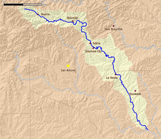
Cibolo Creek is a stream in South Central Texas that runs approximately 96 miles (154 km) from its source at Turkey Knob near Boerne, Texas, to its confluence with the San Antonio River in Karnes County. The creek is a tributary of the San Antonio River, at the easternmost part of its watershed.

Bastrop State Park is a state park in Bastrop County, Texas, United States. The park was established in 1933 and consists of stands of loblolly pines mixed with post oak and junipers.
Eisenhower State Park is a state park located in Grayson County, Texas, northwest of Denison, Texas on the shores of Lake Texoma. The park is 423.1 acres (171 ha).

The Sporting District was a red-light district in the U.S. city of San Antonio, Texas in the late 19th and early 20th centuries. It was established by the city council to manage prostitution in the city. For a time it was one of the nation's largest vice districts with venues ranging from brothels to gambling halls. The area was officially shut down in 1941 resulting from the mobilization for World War II.

Camp Griffiss was a US military base in the United Kingdom during and after World War II. Constructed within the grounds of Bushy Park in Middlesex,, England, it served as the European Headquarters for the United States Army Air Forces from July 1942 to December 1944. From here Dwight D. Eisenhower planned the D-Day invasion. Most of the camp's huts had been removed by the early 1960s, and a memorial tablet now stands on the site.
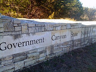
First opened to the public in October, 2005, Government Canyon State Natural Area (GCSNA) preserves 12,244 acres of rugged hills and canyons typical of the Texas Hill Country. It is designated a Natural Area, rather than a State Park, and therefore the primary focus is maintenance and protection of the property's natural state. Accordingly, access and recreational activities may be restricted if the Texas Parks & Wildlife Department (TPWD) deems such action necessary to protect the environment.

Bonham State Park is a 261-acre (1.06 km2) state park located in Bonham, Texas. It includes a 65-acre (260,000 m2) lake, rolling prairies, and woodlands.

Bentsen-Rio Grande Valley State Park is located at 2800 S. Bentsen Palm Drive south of the city of Mission in Hidalgo County in the U.S. state of Texas. It serves as the headquarters for the World Birding Center.

Mission Tejas State Park is a 660-acre (270 ha) state park located along Texas State Highway 21 in Houston County, Texas, originally constructed in 1935 and transferred to Texas Parks and Wildlife in 1957. The closest major town is Crockett, Texas. The park is open year-round.
Phil Hardberger Park is a public city park of San Antonio, Texas which opened in May 2010.
Lake Bardwell is a lake in Ellis County, Texas. The lake was constructed by the United States Army Corps of Engineers in 1965. Lake Bardwell is not used for military operations, and is accessible to the public for recreational purposes; it has seven facilities, but the state public ramp is closed.


