Alamo Heights, Texas

Last updated

Alamo Heights, Texas
City
Ahbroadway.jpg
Broadway Street
Bexar AlamoHeights.svg
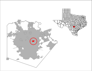
Location of Alamo Heights, Texas
Coordinates: 29°28′58″N98°28′2″W / 29.48278°N 98.46722°W / 29.48278; -98.46722
Country Flag of the United States.svg United States
State Flag of Texas.svg Texas
County Bexar
Government
  Type Council-Manager
   City Council Mayor Bobby Rosenthal
Lawson Jessee
Blake Bonner
Karl Baker
Lynda Billa Burke
John Savage
Area
[1]
  Total1.84 sq mi (4.77 km2)
  Land1.84 sq mi (4.77 km2)
  Water0.00 sq mi (0.00 km2)
Elevation
[2]
801 ft (244 m)
Population
 (2020) [3]
  Total7,357
  Density4,678.98/sq mi (1,806.42/km2)
Time zone UTC-6 (Central (CST))
  Summer (DST) UTC-5 (CDT)
ZIP code
78209
Area codes 210, 726 (planned)
FIPS code 48-01600 [4]
GNIS feature ID1329300 [2]
Website www.alamoheightstx.gov

Alamo Heights is an incorporated city that is surrounded by the city of San Antonio in Bexar County in the U.S. state of Texas. At the time of the 2020 census, the population of Alamo Heights was 7,357. [5] It is part of the Greater San Antonio metropolitan area. A portion of the University of the Incarnate Word is in Alamo Heights.

Contents

Alamo Heights is about 5 miles (8 km) north of downtown San Antonio, the urban core of the seventh-largest city in America, and is almost completely surrounded by the city of San Antonio. [6]

Geography

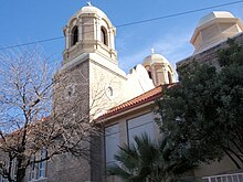
St. Peter Prince of the Apostles St. Peter's Church, Alamo Heights, TX.jpg
St. Peter Prince of the Apostles
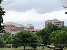
A view from Brackenridge Park Alamo Heights SA.JPG
A view from Brackenridge Park

Alamo Heights is located at 29°28′58″N98°28′2″W / 29.48278°N 98.46722°W / 29.48278; -98.46722 (29.482881, –98.467271). [7] It is bordered by the following neighborhoods: Lincoln Heights to the north, Olmos Park to the west, Brackenridge Park and Fort Sam Houston to the south, and Terrell Hills to the east. All of them are districts within San Antonio except for Terrell Hills and Olmos Park, both independent municipalities similarly to Alamo Heights. Alamo Heights is approximately 3 miles (5 km) south of the San Antonio International Airport and 5 miles (8 km) north of downtown San Antonio, both of which are accessible via Broadway and U.S. 281 North.

According to the United States Census Bureau, Alamo Heights has a total area of 1.9 square miles (4.8 km2), all land. [5]

Demographics

Historical population
CensusPop.Note
1930 3,874
1940 5,70047.1%
1950 8,00040.4%
1960 7,552−5.6%
1970 6,933−8.2%
1980 6,252−9.8%
1990 6,5024.0%
2000 7,31912.6%
2010 7,031−3.9%
2020 7,3574.6%
U.S. Decennial Census [8]
Alamo Heights racial composition as of 2020 [9]
(NH = Non-Hispanic) [lower-alpha 1]
RaceNumberPercentage
White (NH)5,40273.43%
Black or African American (NH)630.86%
Native American or Alaska Native (NH)80.11%
Asian (NH)1652.24%
Pacific Islander (NH)10.01%
Some Other Race (NH)350.48%
Mixed/Multi-Racial (NH)2413.28%
Hispanic or Latino 1,44219.6%
Total7,357

As of the 2020 United States census, there were 7,357 people, 3,223 households, and 2,158 families residing in the city.

As of the 2000 U.S. Census, there were 7,319 people, 3,197 households, and 1,819 families residing in this city. The population density was 3,964.9 inhabitants per square mile (1,530.9/km2). There were 3,460 housing units at an average density of 1,874.4 units per square mile (723.7 units/km2). The racial makeup of this town was 93.80% White, 0.56% African American, 0.33% Native American, 0.85% Asian, 0.01% Pacific Islander, 2.81% from other races, and 1.64% from two or more races. Hispanic or Latino of any race were 13.55% of the population.

There were 3,197 households, out of which 28.1% had children under the age of 18 living with them, 46.5% were married couples living together, 7.9% had a female householder with no husband present, and 43.1% were non-families. 38.3% of all households were made up of individuals, and 12.9% had someone living alone who was 65 years of age or older. The average household size was 2.16 and the average family size was 2.91.

In the city, the population was spread out, with 22.3% under the age of 18, 6.2% from 18 to 24, 29.2% from 25 to 44, 25.1% from 45 to 64, and 17.2% who were 65 years of age or older. The median age was 40 years. For every 100 females, there were 82.5 males. For every 100 females age 18 and over, there were 75.0 males.

The median income per household in Alamo Heights was $77,257 in 2008 (compared to $64,688 in 2000), while the median per family income was $86,897. Males had a median income of $60,527 versus $37,089 for females. The per capita income for the city was estimated to be $56,335 in 2008. About 1.6% of families and 3.5% of the population were below the poverty line, including 3.7% of those under age 18 and 6.4% of those age 65 or over.

Estimated median house or condo value in 2008 was $341,600 (compared to $202,200 in 2000).

Mean prices in 2008: All housing units: $440,427. Detached houses: $437,838. Townhouses or other attached units: $373,366. In 2-unit ("duplex") structures: $200,395. In 3-to-4-unit ("triplex" to "fourplex") structures: $294,787. In 5-or-more-unit structures: $491,936.

Federal government offices

The United States Postal Service operates the Alamo Heights Post Office. [11]

Education

Primary and secondary schools

Alamo Heights is served by the Alamo Heights Independent School District, which has its headquarters in the city limits. [12] [13] [14]

Howard Early Childhood Center in San Antonio serves early childhood residents. [15] Most residents are zoned to Cambridge Elementary School in Alamo Heights, [12] [16] [17] while some are zoned to Woodridge Elementary School in San Antonio. [16] [18] All residents are zoned to Alamo Heights Junior School in San Antonio and Alamo Heights High School which is situated in Alamo Heights at 6900 Broadway. [12] [16] [19]

Private schools within the town limits are St. Peter Prince of the Apostles Catholic School (K–8) and St. Luke's Episcopal School (Pre-K–8). Nearby private schools outside the town limits include The San Antonio Academy in Monte Vista (Pre-K–8), Keystone School in Monte Vista (Pre-K–12), St. Mary's Hall (San Antonio, Texas) (K–12), Incarnate Word High School in San Antonio (9–12), St. Anthony Catholic School in Monte Vista (Pre-K3–8), St. Anthony Catholic High School (9–12) in Monte Vista, and St. Pius X in San Antonio (K–8).

Colleges and universities

The University of the Incarnate Word is partially within Alamo Heights. [12] [20] Trinity University is 1 mile (1.6 km) southwest of the city limits in the San Antonio district of Monte Vista.

Public libraries

There are no public libraries in Alamo Heights. The Landa Memorial Library of the San Antonio Public Library, located in the Monte Vista Historic District in San Antonio, is the most proximal. [21]

Quarry Market Shopping Center Quarry Market.jpg
Quarry Market Shopping Center

History

The City of Alamo Heights was incorporated in 1922. Eventual growth to the north would happen later with the annexation of Bluebonnet Hills and Sylvan Hills in 1928 and 1944, respectively.[ citation needed ]

Attractions

The Alamo Quarry Market shopping center, Quarry Village, Lincoln Heights Shopping Center, H-E-B's Central Market, North Star Mall, McNay Art Museum, and the headquarters for Clear Channel Communications can be found outside Alamo Heights.

Related Research Articles

<span class="mw-page-title-main">San Antonio</span> City in Texas, United States

San Antonio, officially the City of San Antonio, is a city in and the county seat of Bexar County, Texas, United States. The city is the seventh-most populous in the United States, the second-largest in the Southern United States, and the second-most populous in Texas after Houston. San Antonio is the largest city of the San Antonio–New Braunfels metropolitan statistical area. Commonly called Greater San Antonio, the metropolitan area had a population of 2,601,788 based on the 2020 U.S. census estimates, making it the 24th-largest metropolitan area in the United States and third-largest in Texas.

<span class="mw-page-title-main">Starr County, Texas</span> County in Texas, United States

Starr County is located in the U.S. state of Texas. As of the 2020 census, its population was 65,920. Its county seat is Rio Grande City. The county was created in 1848. It is named for James Harper Starr, who served as secretary of the treasury of the Republic of Texas.

<span class="mw-page-title-main">Bexar County, Texas</span> County in Texas, United States

Bexar County is a county in the U.S. state of Texas. It is in South Texas and its county seat is San Antonio.

<span class="mw-page-title-main">South El Monte, California</span> City in California, United States

South El Monte is a city in the San Gabriel Valley, in Los Angeles County, California, United States. At the 2010 census, the city had a population of 20,116, down from 21,144 at the 2000 census.

<span class="mw-page-title-main">Balcones Heights, Texas</span> City in Texas, United States

Balcones Heights is a city in Bexar County, Texas, United States. Its population was 2,746 at the 2020 census, and it was incorporated in 1948. Balcones Heights is an enclave of San Antonio, surrounded entirely by the city, thus some residents and out-of-town visitors erroneously consider it merely a neighborhood of the larger city rather than its own unique community that did so to prevent annexation.

<span class="mw-page-title-main">Cross Mountain, Texas</span> Census-designated place in Texas, United States

Cross Mountain is a census-designated place (CDP) in Bexar County, Texas, United States. The population was 3,944 at the 2020 census, an increase over the figure of 3,124 tabulated in 2010. It is part of the San Antonio Metropolitan Statistical Area.

<span class="mw-page-title-main">Grey Forest, Texas</span> City in Texas, United States

Grey Forest is a city in northwestern Bexar County, Texas, United States. The population was 492 at the 2020 census. It is part of the San Antonio Metropolitan Statistical Area.

<span class="mw-page-title-main">Olmos Park, Texas</span> City in Texas, United States

Olmos Park is a city in Bexar County, Texas, United States. The population was 2,180 at the 2020 census. The town is noted for its park-like setting, oak-tree lined streets, and large estates, many of which were constructed during the 1920s. The town is four miles north of downtown San Antonio and is surrounded by the city of San Antonio on the west, north, and south side.

<span class="mw-page-title-main">Scenic Oaks, Texas</span> Census-designated place in Texas, United States

Scenic Oaks is a census-designated place (CDP) in Bexar County, Texas, United States. It is part of the San Antonio Metropolitan Statistical Area. The population was 10,458 at the 2010 census, up from 4,957 at the 2010 census.

<span class="mw-page-title-main">Shavano Park, Texas</span> City in Texas, United States

Shavano Park is a city located in Bexar County, Texas, United States. As of the 2020 census, the population was 3,524, an increase over the figure of 3,035 tabulated in 2010. It is part of the San Antonio Metropolitan Statistical Area, despite being much different in terms of demographics and having some of the wealthiest families in Bexar County.
<span class="mw-page-title-main">Terrell Hills, Texas</span> City in Texas, United States

Terrell Hills is a city in Bexar County, Texas, United States; it is located 5 miles (8 km) northeast of downtown San Antonio. As of the 2020 census Terrell Hills had a population of 5,045. It is part of a group of three cities—Terrell Hills, Alamo Heights, and Olmos Park—located between Uptown San Antonio, Midtown San Antonio, Downtown San Antonio, and Fort Sam Houston. Terrell Hills is bordered on the west by Alamo Heights, on the east by Fort Sam Houston, on the north by Uptown San Antonio, and on the south by San Antonio's Near East Side. It is part of the San Antonio Metropolitan Statistical Area.
<span class="mw-page-title-main">Universal City, Texas</span> City in Texas, United States

Universal City is a city in Bexar County, Texas, United States with a small portion in Guadalupe County, Texas. It borders San Antonio to the northeast, and is adjacent to Randolph Air Force Base. The city also borders Schertz, Texas and Selma, Texas to its east, Live Oak, Texas to its north, and Converse, Texas to its south. Selma, Texas is one of the cities that make up the San Antonio Northeast Metrocom, which includes Cibolo, Texas, Converse, Texas, Garden Ridge, Texas, Kirby, Texas, Live Oak, Texas, Marion, Texas, New Berlin, Texas, Santa Clara, Texas, Selma, Texas, Schertz, Texas, Universal City, Texas, and Windcrest, Texas. The population was 19,720 at the 2020 census. It is part of the San Antonio Metropolitan Statistical Area.
<span class="mw-page-title-main">Seadrift, Texas</span> City in Texas, United States

Seadrift is a city in Calhoun County, Texas, United States. The population was 1,364 at the 2010 census. It is a part of the Victoria, Texas Metropolitan Statistical Area.

<span class="mw-page-title-main">Bayou Vista, Texas</span> City in Texas, United States

Bayou Vista is a city in Galveston County, Texas, United States. The population was 1,537 at the 2010 census. It received severe damage from Hurricane Ike on September 13, 2008.

<span class="mw-page-title-main">Alamo, Texas</span> City in Texas

Alamo, located in the Rio Grande Valley in what is nicknamed the "Land of Two Summers", is a city in the irrigated area of southern Hidalgo County, Texas, United States. Known as the "Refuge to the Valley", it is located in an area of abundant vegetable farming and citrus groves, and is a noted winter resort/retirement town near the Mexico–U.S. border. Alamo is one of the Rio Grande Valley's gateways to Mexico, via U.S. Route 281 and Nuevo Progreso, Tamaulipas, as well as a gateway to the Santa Ana National Wildlife Refuge. Alamo's population was 18,353 at the 2010 census and an estimated 19,910 in 2019.

<span class="mw-page-title-main">Lopezville, Texas</span> Census-designated place in Texas

Lopezville is a census-designated place (CDP) in Hidalgo County, Texas. The population was 4,333 at the 2010 United States Census. It is part of the McAllen–Edinburg–Mission Metropolitan Statistical Area. The town developed during the early 1960s as a trailer park. It is named for Francisco Solano López, a former president of Paraguay, a descendant of whom founded his namesake trailer park.

<span class="mw-page-title-main">San Juan, Texas</span> City in Texas

San Juan is a city in Hidalgo County, Texas, United States. As of the 2020 census the population was 35,294, up from 33,856 in 2010. It is part of the McAllen–Edinburg–Mission and Reynosa–McAllen metropolitan areas.
<span class="mw-page-title-main">Brackettville, Texas</span> City in Texas, United States

Brackettville is a city in Kinney County, Texas, United States. The population was 1,688 at the 2010 census, down from 1,876 at the 2000 census. It is the county seat of Kinney County.

<span class="mw-page-title-main">Greater San Antonio</span> Metropolitan area in Texas, United States

Greater San Antonio, officially designated San Antonio–New Braunfels, is an eight-county metropolitan area in the U.S. state of Texas defined by the Office of Management and Budget (OMB). The metropolitan area straddles South Texas and Central Texas and is on the southwestern corner of the Texas Triangle. The official 2020 U.S. census showed the metropolitan area's population at 2,558,143—up from a reported 1,711,103 in 2000—making it the 24th largest metropolitan area in the United States. Downtown Austin and Downtown San Antonio are approximately 80 miles (129 km) apart, and both fall along the Interstate 35 corridor. This combined metropolitan region of San Antonio–Austin has approximately 5 million people.

<span class="mw-page-title-main">Monte Vista Historic District</span> District of San Antonio

The Monte Vista Historic District is a neighborhood of about 3,000 people located in Midtown San Antonio, Texas, USA. The district stretches from the southern area near San Antonio College to its most northern point along Hildebrand Avenue. It was officially registered in the National Register of Historic Places in 1998. Because of this, homeowners must adhere to rules and regulations set by the San Antonio Office of Historical Preservation and approved by the San Antonio Historic Design and Review Commission as well as the San Antonio City Council.

References

  1. "2019 U.S. Gazetteer Files". United States Census Bureau. Retrieved August 7, 2020.
  2. 1 2 U.S. Geological Survey Geographic Names Information System: Alamo Heights, Texas
  3. "State and County Quick Facts". United States Census Bureau. Archived from the original on January 6, 2015. Retrieved January 6, 2015.
  4. "U.S. Census website". United States Census Bureau . Retrieved January 31, 2008.
  5. 1 2 "Geographic Identifiers: 2010 Demographic Profile Data (G001): Alamo Heights city, Texas". U.S. Census Bureau, American Factfinder. Archived from the original on February 12, 2020. Retrieved April 11, 2014.
  6. "Distance between Alamo Heights, TX and San Antonio, TX 7 Miles - 11 Km".
  7. "US Gazetteer files: 2010, 2000, and 1990". United States Census Bureau. February 12, 2011. Retrieved April 23, 2011.
  8. "Census of Population and Housing". Census.gov. Retrieved June 4, 2015.
  9. "Explore Census Data". data.census.gov. Retrieved May 24, 2022.
  10. "About the Hispanic Population and its Origin". www.census.gov. Retrieved May 18, 2022.
  11. "Post Office Location - ALAMO HEIGHTS." United States Postal Service . Retrieved on April 16, 2009.
  12. 1 2 3 4 Zoning Map Archived 2009-08-24 at the Wayback Machine ." City of Alamo Heights. Retrieved on March 24, 2010.
  13. "AHISD Contact Information Archived 2010-05-12 at the Wayback Machine ." Alamo Heights Independent School District. Retrieved on March 24, 2010.
  14. "Alamo Heights city, Texas Archived 2011-06-06 at the Wayback Machine ." U.S. Census Bureau. Retrieved on May 22, 2010.
  15. "Welcome Archived 2010-04-10 at the Wayback Machine ." Howard Early Childhood Center. Retrieved on March 24, 2010.
  16. 1 2 3 "Zoning Map Archived 2010-06-12 at the Wayback Machine ." Alamo Heights Independent School District. Retrieved on March 24, 2010.
  17. "Welcome to Cambridge Elementary School Archived 2010-04-02 at the Wayback Machine ." Alamo Heights Independent School District. Retrieved on March 24, 2010.
  18. "District Map PDF Archived 2010-06-12 at the Wayback Machine ." Alamo Heights Independent School District. Retrieved on March 24, 2010.
  19. "Welcome to the Alamo Heights Junior High School Archived 2010-03-25 at the Wayback Machine ." Alamo Heights Independent School District. Retrieved on March 24, 2010.
  20. "Campus Map Archived 2010-05-27 at the Wayback Machine ." University of the Incarnate Word. Retrieved on March 24, 2010.
  21. "Landa Library." San Antonio Public Library. Retrieved on March 25, 2010.
  1. Note: the US Census treats Hispanic/Latino as an ethnic category. This table excludes Latinos from the racial categories and assigns them to a separate category. Hispanics/Latinos can be of any race. [10]