London is an unincorporated community in northeast Kimble County, Texas, United States. According to the Handbook of Texas, the community had an estimated population of 180 in 2000.
Pollok is an unincorporated community in Angelina County, Texas, United States. According to the Handbook of Texas, the community had a population of 300 in 2000. It is located within the Lufkin, Texas micropolitan area.
Vanderpool is a small unincorporated community in Bandera County, in the U.S. state of Texas, in the Texas Hill Country, which is part of the Edwards Plateau. According to the Handbook of Texas, Vanderpool had a population of 22 in 1990. It is considered part of the San Antonio Metropolitan Statistical Area.
Wadsworth is an unincorporated community in Matagorda County, Texas, United States. According to the Handbook of Texas, the community had an estimated population of 180 in 2000.

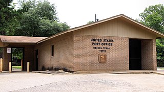
Neches is an unincorporated community in east central Anderson County, in the U.S. state of Texas. According to the Handbook of Texas, the community had a population of 175 in 2000. It is located within the Palestine, Texas micropolitan area.
Cherokee is an unincorporated community in San Saba County in western Central Texas. According to the Handbook of Texas, the community had an estimated population of 175 in 2000.
May is an unincorporated community in Brown County, Texas, United States. According to the Handbook of Texas, the community had an estimated population of 285 in 2000. May was designated a Recorded Texas Historic Landmark in 1981, with marker number 5377. In 2001, historical marker 12532 was added for May United Methodist Church, commemorating the church's presence in the community for over 100 years. The May Cemetery was designated an Historic Texas Cemetery in 2016.
Medina is an unincorporated community in Bandera County, Texas, United States. It is part of the San Antonio Metropolitan Statistical Area. Medina is famous for its apples. The community's population was estimated to be 515 in 2000.

Ledbetter is an unincorporated community on U.S. Route 290 in far northern Fayette County, Texas, United States. Ledbetter has a post office with the ZIP code 78946.

Spicewood is an unincorporated community in Burnet County, Texas, United States. According to the Texas Almanac, the community had an estimated population of 2,000 in 2000. But in the 2011 census, the community had a population of 7,666. The community also extends towards Travis County off of Highway 71.
Macdona is an unincorporated community and census-designated place in Bexar County, Texas, United States. As of the 2010 census it had a population of 559. Macdona lies along the Union Pacific rail line near Loop 1604 in southwest Bexar County. It is part of the San Antonio Metropolitan Statistical Area.

Briggs is an unincorporated community in eastern Burnet County, Texas, United States. It lies along U.S. Route 183 and FM 2657 northeast of Burnet. Its elevation is 1,102 feet (336 m), and it is located at 30°53′23″N97°55′30″W. Although Briggs is unincorporated, it has a post office, with the ZIP code of 78608; the ZCTA for ZIP Code 78608 had a population of 279 at the 2000 census.
Vancourt is an unincorporated community in eastern Tom Green County, Texas, United States. It lies along U.S. Route 87 east of the city of San Angelo, the county seat of Tom Green County. Its elevation is 1,867 feet (569 m). Although Vancourt is unincorporated, it has a post office, with the ZIP code of 76955; the ZCTA for ZIP Code 76955 had a population of 108 at the 2000 census.
Dodge is an unincorporated community in eastern Walker County, Texas, United States, on the northern edge of the Sam Houston National Forest. It lies along FM 405 east of the city of Huntsville, the county seat of Walker County. Its elevation is 400 feet (122 m). Although Dodge is unincorporated, it has a post office, with the ZIP code of 77334; the ZCTA for ZIP Code 77334 had a population of 184 at the 2000 census.

Danevang is an unincorporated community in southern Wharton County, in the U.S. state of Texas. The rural community is located south of El Campo on State Highway 71 (SH 71). The name Danevang means Dane Meadow. The town was founded in the 1890s mostly by Danes who migrated from the American Midwest. After a period of prosperity people began moving away in the 1920s. The community's church was still open in 2013.

Cedar Creek is an unincorporated community in Bastrop County, Texas, United States, located 11 miles (18 km) west of Bastrop at the intersection of State Highway 21 and Farm to Market Road 535. Cedar Creek has a post office with a ZIP code 78612. The community takes its name from Cedar Creek, a tributary of the Colorado River.

DeBerry is an unincorporated community in Panola County, Texas, United States. The community has an estimated population of 3,305.
Rosanky is an unincorporated community located on Farm to Market Road 535 in southern Bastrop County, Texas, United States. Rosanky has a post office with the ZIP code 78953. The town is named for Ed Rosanky, who emigrated from Prussia and settled in the area in 1854.
Judson is an unincorporated community in Gregg County, Texas, United States. According to the Handbook of Texas, the community had an estimated population of 650 in 2000. It is part of the Longview, Texas Metropolitan Statistical Area.
Camp Verde is an unincorporated community in Kerr County. The town is approximately the halfway point between Bandera and Kerrville along SH 173 in the Texas Hill Country.


