
Medellín, officially the Special District of Science, Technology and Innovation of Medellín, is the second-largest city in Colombia after Bogotá, and the capital of the department of Antioquia. It is located in the Aburrá Valley, a central region of the Andes Mountains, in northwestern South America. The city's population was 2,508,452 at the 2018 census. The metro area of Medellín is the second-largest urban agglomeration in Colombia in terms of population and economy, with more than 4 million people.

Alejandría is a town and municipality in the Antioquia Department, Colombia. It is part of the sub-region of Eastern Antioquia and is bordered to the north by the municipalities of Concepción, Santo Domingo and San Roque, on the east by the municipality of San Rafael, on the south by the municipalities of San Rafael and Guatapé, and on the west by the municipalities of El Penol and Concepción. Its capital is 90 kilometers from the city of Medellin, the capital of Antioquia department. The municipality has an area of 149 km2.

Bello is a city and municipality in Antioquia Department, Colombia and a suburb of Medellín, the department capital. Bello is part of the Metropolitan Area of the Aburrá Valley in the department of Antioquia. It is bordered on the north by the municipality of San Pedro de los Milagros, on the east by the municipality of Copacabana, on the south by the municipality of Medellín and on the west by the municipalities of Medellín and San Jerónimo.
Carolina del Príncipe is a town and municipality in the Colombian department of Antioquia, located 105 km north of Medellín, with an altitude of 1,807 m above sea level. Carolina del Príncipe is part of the subregion of Northern Antioquia.
Don Matías is a municipality in Antioquia Department, Colombia. Part of the subregion of Northern Antioquia. Bordered to the north by the municipality of Santa Rosa de Osos, to the east by the municipalities of Santa Rosa de Osos and Santo Domingo, to the south by the municipality of Barbosa, and to the west by the municipality of San Pedro de los Milagros.

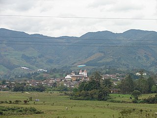
Guatapé is a town and municipality in the Department of Antioquia, Colombia. It is a part of the subregion of Eastern Antioquia and is located 79 kilometres (49 mi) from Medellín, the capital of the department. Guatapé is bordered on the north by Alejandría, San Rafael to the east, and Granada and El Peñol to the south. This town is the gathering place for Las Vegas, referring to the small farms of the area.

Santa Rosa de Osos is a middle city and municipality of Colombia located in the northern of the department of Antioquia. Bounded on the north with the municipalities of Yarumal and Angostura, on the east with Guadalupe and Carolina del Principe, on the south with the municipalities of Donmatías, San Pedro de los Milagros and Entrerríos, and on the west with Belmira and San José de la Montaña.

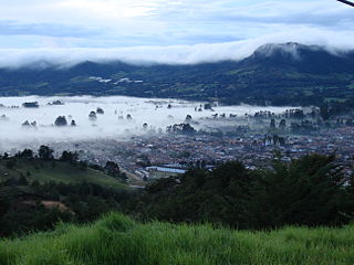
Sonsón is a municipality in the Colombian department of Antioquia. Sonsón is located in Eastern Antioquia. It is one of the seats of the Roman Catholic Diocese of Sonsón–Rionegro. Sonsón celebrates "Las Fiestas Del Maíz"- during the month of August, being the most traditional, historical and representative festival in western Colombia. The population was estimated to be 33,598 in 2020.

El Peñol is a town and municipality in Antioquia Department, Colombia. The population was 16,223 at the 2018 census. It is part of the subregion of Eastern Antioquia. The town is nationally known for the nearby monolith known also as El Peñol, which is a tourist attraction.

Puerto Berrío is a municipality and town in the Colombian department of Antioquia. It is part of the Magdalena Medio Antioquia sub-region.

Rionegro is a city and municipality in Antioquia Department, Colombia, located in the subregion of Eastern Antioquia. The official name of the city is Ciudad Santiago de Arma de Rionegro. Rio Negro means "Black River" in Spanish, as the city received its name after a river that looks black because of the shadows cast by trees. The river traverses the city and it is the most prominent geographical feature of the municipality. Rionegro is also sometimes called the Cuna de la democracia as it was one of the most important cities during the era of the Colombia's struggle for independence and the 1863 constitution was written in the city.
San Jerónimo is a municipality in Colombia, located in the Western subregion of the Department of Antioquia. Its main town is 35 kilometers from the city of Medellín, the capital of the department of Antioquia. The municipality has an area of 155 square kilometers.

San Luis is a municipality in Colombia, located in the department of Antioquia. It is limited in the north by the municipalities of San Carlos and Puerto Nare, in the east by the municipality of Puerto Triunfo, in the south by the municipality of San Francisco and in the west by the municipalities of Cocorná and Granada.

Eastern Antioquia is subregion of the Colombian Department of Antioquia. The region consists of 23 municipalities.
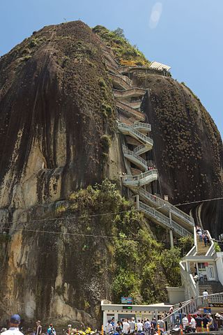
The Rock of Guatapé is a landmark inselberg in Colombia. It is located in the town and municipality of Guatapé, Antioquia. It is also known as The Stone of El Peñol, or simply La Piedra or El Peñol, as the town of El Peñol, which borders Guatapé, has also historically claimed the rock as their own and thus has led to different names for the site.
La Ceja del Tambo, known as La Ceja, is a town and municipality in the Antioquia Department of Colombia. It is part of the subregion of Eastern Antioquia. La Ceja borders the Rionegro and Carmen de Viboral municipalities to the north, La Unión to the east, and Montebello and Retiro to the west. It is located approximately 41 kilometers from Medellín, the department capital.

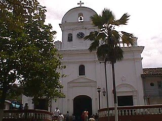
Our Lady of Chiquinquirá Cathedral is a Roman Catholic cathedral situated in the city of Sonsón, Colombia. The present cathedral was built to replace the original destroyed by an earthquake in 1962.

The coat of arms of Medellín is the heraldic emblem that represents the Colombian city of Medellín, capital of the department of Antioquia. It has its origin in the concession of its use by King Charles II of Spain by means of the Royal Decree given in Madrid on March 31, 1678. The escutcheon also recalled in some of its elements the ancient coat of arms of the Spanish town of Medellín, in Extremadura, from which the city takes its name.


