
The Berkeley Rose Garden is a city-owned park in the North Berkeley area of Berkeley, California. The Rose Garden is situated in a residential area of the Berkeley Hills between the Cragmont and La Loma Park neighborhoods, occupying most of the block between Eunice Street and Bayview Place along the west side of Euclid Avenue.

Strawberry Creek is the principal watercourse running through the city of Berkeley, California. Two forks rise in the Berkeley Hills of the California Coast Ranges, and form a confluence at the campus of the University of California, Berkeley. The creek then flows westward across the city to discharge into San Francisco Bay.

Temescal Creek is one of the principal watercourses in the city of Oakland, California, United States.
La Loma Park is a tract of land located in the Berkeley Hills section of the city of Berkeley, California in the San Francisco Bay Area. The Spanish word loma means "rise/low hill". It was the property of Captain Richard Parks Thomas, a veteran of the Civil War and Berkeley businessman. Today, it is entirely a residential area. Although hilly throughout, its average elevation is about 614 feet.

The Berkeley Marina is the westernmost portion of the city of Berkeley, California, located west of the Eastshore Freeway at the foot of University Avenue on San Francisco Bay. Narrowly speaking, "Berkeley Marina" refers only to the city marina, but in common usage, it applies more generally to the surrounding area.
West Berkeley is generally the area of Berkeley, California, that lies west of San Pablo Avenue, abutting San Francisco Bay. It includes the area that was once the unincorporated town of Ocean View, as well as the filled-in areas along the shoreline west of I-80, mainly including the Berkeley Marina. It lies at an elevation of 23 feet.

Aquatic Park is a public park in Berkeley, California, United States, located just east of the Eastshore Freeway between Ashby and University Avenues. The Works Progress Administration created the park in the 1930s simultaneously with the nearby Berkeley Yacht Harbor. Its centerpiece is an artificial mile-long lagoon that was cut off from San Francisco Bay by the creation of a causeway for the Eastshore Highway, during the construction of the approaches to the San Francisco–Oakland Bay Bridge, also in the 1930s. The lagoon still communicates with the Bay through culverts under the freeway. The east shoreline of the lagoon used to be the original shoreline of San Francisco Bay.
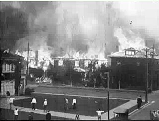
The 1923 Berkeley Fire was a conflagration that consumed some 640 structures, including 584 homes in the densely-built neighborhoods north of the campus of the University of California in Berkeley, California on September 17, 1923.
Baxter Creek or Stege Creek, is a three-branch creek in Richmond and El Cerrito, California, United States, forming the Baxter Creek watershed. The creek has three sources and flows from the Berkeley Hills to Stege Marsh and the San Francisco Bay. The Baxter Creek watershed at-large has 10 sources.

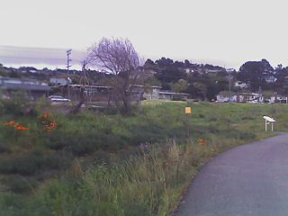
Cerrito Creek is one of the principal watercourses running out of the Berkeley Hills into San Francisco Bay in northern California. It is significant for its use as a boundary demarcation historically, as well as presently. In the early 19th century, it separated the vast Rancho San Antonio to the south from the Castro family's Rancho San Pablo to the north. Today, it marks part of the boundary between Alameda County and Contra Costa County. The main stem, running through a deep canyon that separates Berkeley from Kensington, is joined below San Pablo Avenue by a fan of tributaries, their lower reaches mostly in culverts. The largest of these is Middle or Blackberry Creek, a southern branch.

Hayward Regional Shoreline is a regional park located on the shores of the San Francisco Bay in Hayward, California. It is part of the East Bay Regional Parks system. The 1,713 acre park extends to the shores of San Lorenzo. Part of the park is former commercial salt flats purchased in 1996. A former landfill, now capped with soil and plants, is located in the park. The park includes the 250 acre tidal wetland, Cogswell Marsh, and the 364 acre Oro Loma Marsh. Located to the south of the park is the Hayward Shoreline Interpretive Center, which provides information on the Bay shore habitats. The San Francisco Bay Trail runs through the park, which connects the park with San Lorenzo Creek.
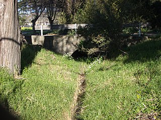
Fluvius Innominatus or Central Creek is a creek in Richmond and El Cerrito, California in western Contra Costa County. There is one main source and a secondary unnamed tributary. The creek drains into Hoffman Marsh and then flows into the bay through Point Isabel Regional Shoreline's Hoffman Channel. However, before the area was developed and as early as 1899 the creek had 11 sources which stretched far higher into the Berkeley Hills.

The Hydrography of the San Francisco Bay Area is a complex network of watersheds, marshes, rivers, creeks, reservoirs, and bays predominantly draining into the San Francisco Bay and Pacific Ocean.
Hoffman Marsh is a wetlands on San Francisco Bay in Richmond, California. The marsh has been protected within Eastshore State Park, and adjacent to Point Isabel Regional Shoreline. The marsh is an important nesting ground for wildfowl and stopping ground on the Pacific Flyway, as it is one of only a handful of undestroyed wetlands in the Bay Area. It borders Point Isabel Regional Shoreline and Interstate 80.
Marin Creek is a creek tributary of Codornices Creek in northwestern Alameda County, California. The lower stretch of Marin Creek is also known as Village Creek.

The Albany Bulb is a former landfill largely owned by the City of Albany, in California. The Bulb is the west end of a landfill peninsula jutting west from the east shore of San Francisco Bay. The term "Bulb" is often used to refer to the entire peninsula, which includes the Albany Plateau, north of Buchanan Street at its base; the high narrow "Neck," and the round "Bulb." The Bulb is part of the City of Albany, and can be reached via Buchanan Street or the Bay Trail along the east side of San Francisco Bay.

The Northbrae Tunnel, also referred to as the Solano Avenue Tunnel, was built as a commuter electric railroad tunnel in the northern part of Berkeley, California and was later converted to street use.
Friends of Five Creeks is a regional community volunteer organization founded in 1996 by Sonja Wadman originally dedicated to the stewardship of creeks in northern Alameda County and western Contra Costa, California, United States. Education about wildlife and restoration is also a major facet of the FFC's mission.


