Seabrook Farms, New Jersey

Last updated

Seabrook Farms, New Jersey
Cumberland County New Jersey Incorporated and Unincorporated areas Seabrook Farms Highlighted.svg
Map of Seabrook Farms highlighted within Cumberland County. Right: Location of Cumberland County in New Jersey.
Location map of Cumberland County, New Jersey.svg
Red pog.svg
Seabrook Farms
Location in Cumberland County
USA New Jersey relief location map.svg
Red pog.svg
Seabrook Farms
Location in New Jersey
Usa edcp relief location map.png
Red pog.svg
Seabrook Farms
Location in the United States
Coordinates: 39°30′04″N75°13′13″W / 39.501155°N 75.220355°W / 39.501155; -75.220355
Country Flag of the United States.svg  United States
State Flag of New Jersey.svg  New Jersey
County Cumberland
Township Upper Deerfield
Area
[1]
  Total2.18 sq mi (5.64 km2)
  Land2.17 sq mi (5.61 km2)
  Water0.01 sq mi (0.03 km2)  0.47%
Elevation
[2]
108 ft (33 m)
Population
 (2020) [3]
  Total1,508
  Density695.89/sq mi (268.64/km2)
Time zone UTC−05:00 (Eastern (EST))
  Summer (DST) UTC−04:00 (EDT)
FIPS code 34-66300 [4] [5]
GNIS feature ID02390267 [6]

Seabrook Farms is an unincorporated community and census-designated place (CDP) [7] located within Seabrook, which is in turn located in Upper Deerfield Township, in Cumberland County, in the U.S. state of New Jersey. [8] It is part of the Vineland-Bridgeton metropolitan statistical area for statistical purposes. [9] At the 2010 census, Seabrook Farms's population was 1,484. [10] Seabrook Farms is named after Charles F. Seabrook, a businessman who ran a truck farm that was one of the state's largest. [11]

Contents

Geography

According to the United States Census Bureau, Seabrook Farms had a total area of 2.177 square miles (5.640 km2), including 2.167 square miles (5.614 km2) of it is land and 0.010 square miles (0.026 km2) of water (0.47%) is water. [12] [13]

Demographics

Historical population
CensusPop.Note
1990 1,457
2000 1,71918.0%
2010 1,484−13.7%
2020 1,5081.6%
Population sources: 2000 [14] 2010 [10] [3]

Census 2010

The 2010 United States census counted 1,484 people, 508 households, and 388 families in the CDP. The population density was 684.7 per square mile (264.4/km2). There were 548 housing units at an average density of 252.8 per square mile (97.6/km2). The racial makeup was 32.41% (481) White, 44.54% (661) Black or African American, 1.21% (18) Native American, 1.15% (17) Asian, 0.00% (0) Pacific Islander, 13.01% (193) from other races, and 7.68% (114) from two or more races. Hispanic or Latino of any race were 21.50% (319) of the population. [10]

Of the 508 households, 46.1% had children under the age of 18; 28.9% were married couples living together; 40.7% had a female householder with no husband present and 23.6% were non-families. Of all households, 19.5% were made up of individuals and 5.1% had someone living alone who was 65 years of age or older. The average household size was 2.92 and the average family size was 3.31. [10]

37.1% of the population were under the age of 18, 11.4% from 18 to 24, 25.1% from 25 to 44, 20.3% from 45 to 64, and 6.1% who were 65 years of age or older. The median age was 25.9 years. For every 100 females, the population had 84.8 males. For every 100 females ages 18 and older there were 73.4 males. [10]

Census 2000

At the 2000 census [4] there were 1,719 people, 582 households, and 451 families residing in Seabrook Farms. The population density was 304.5/km2 (788.8/mi2). There were 607 housing units at an average density of 107.5/km2 (278.5/mi2). The racial makeup of Seabrook Farms was 33.86% White, 54.22% African American, 0.76% Native American, 2.04% Asian, 0.06% Pacific Islander, 6.52% from other races, and 2.56% from two or more races. Hispanic or Latino of any race were 12.91% of the population. [14]

Of the 582 households, 55.3% had children under the age of 18 living with them, 29.7% were married couples living together, 41.4% had a female householder with no husband present, and 22.5% were non-families. 19.8% of households were one person, and 8.4% were one person aged 65 or older. The average household size was 2.95 and the average family size was 3.33. [14]

In Seabrook Farms the population was spread out, with 42.8% under the age of 18, 10.1% from 18 to 24, 26.2% from 25 to 44, 14.9% from 45 to 64, and 6.1% 65 or older. The median age was 23 years. For every 100 females, there were 85.2 males. For every 100 females age 18 and over, there were 67.5 males. [14]

The median household income was in Seabrook Farms was $16,558, and the median family income was $22,500. Males had a median income of $24,479 versus $24,643 for females. The per capita income for Seabrook Farms was $12,499. About 28.3% of families and 34.3% of the population were below the poverty line, including 42.2% of those under age 18 and 16.8% of those age 65 or over. [14]

Related Research Articles

<span class="mw-page-title-main">Barclay-Kingston, New Jersey</span> Former census-designated place in New Jersey, United States

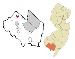
Barclay-Kingston is an unincorporated community and former census-designated place (CDP) located within Cherry Hill Township, in Camden County, New Jersey, United States. As of the 2000 United States Census, the section population was 10,728. In the 2010 United States Census, the Barclay-Kingston CDP was split into two new CDPs, Barclay and Kingston Estates.

<span class="mw-page-title-main">Greentree, New Jersey</span> Populated place in Camden County, New Jersey, US

Greentree is an unincorporated community and census-designated place (CDP) located within Cherry Hill Township, in Camden County, in the U.S. state of New Jersey. As of the 2010 United States Census, the CDP's population was 11,367.

<span class="mw-page-title-main">Springdale, New Jersey</span> Populated place in Camden County, New Jersey, US

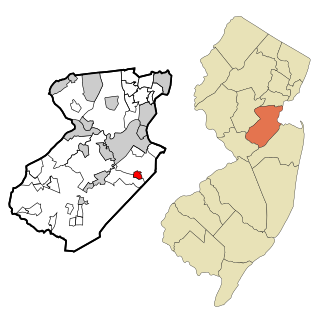
Springdale is an unincorporated community and census-designated place (CDP) located within Cherry Hill Township, in Camden County, in the U.S. state of New Jersey. As of the 2010 United States Census, the section population was 14,518.

<span class="mw-page-title-main">Beckett, New Jersey</span> Populated place in Gloucester County, New Jersey, US

Beckett is an unincorporated community and census-designated place (CDP) within Logan Township, in Gloucester County, in the U.S. state of New Jersey. As of the 2010 United States Census, the CDP's population was 4,847.

<span class="mw-page-title-main">Turnersville, New Jersey</span> Populated place in Gloucester County, New Jersey, US

Turnersville is an unincorporated community and census-designated place (CDP) located within Washington Township, in Gloucester County, in the U.S. state of New Jersey. As of the 2010 United States census, the CDP's population was 3,742.

<span class="mw-page-title-main">Brownville, New Jersey</span> Populated place in Middlesex County, New Jersey, US

Brownville is an unincorporated community and census-designated place (CDP) located within Old Bridge Township, in Middlesex County, in the U.S. state of New Jersey. As of the 2010 United States Census, the CDP's population was 2,383.

<span class="mw-page-title-main">Cranbury (CDP), New Jersey</span> Populated place in Middlesex County, New Jersey, US

Cranbury is an unincorporated community and census-designated place (CDP) located within Cranbury Township, in Middlesex County, in the U.S. state of New Jersey. As of the 2010 United States Census, the CDP's population was 2,181. Despite the similarity in the name of Cranbury Township and the CDP, the two are not one and the same, as had been the case for most paired Township / CDP combinations prior to the 2010 Census, in which the CDP was coextensive with a township of the same name.

<span class="mw-page-title-main">Heathcote, New Jersey</span> Populated place in Middlesex County, New Jersey, US

Heathcote is an unincorporated community and census-designated place (CDP) located within South Brunswick Township, in Middlesex County, in the U.S. state of New Jersey. As of the 2010 United States Census, the CDP's population was 5,821.

<span class="mw-page-title-main">Old Bridge (CDP), New Jersey</span> Census-designated place in New Jersey, United States

Old Bridge is a census-designated place (CDP) in Old Bridge Township, in Middlesex County, in the U.S. state of New Jersey. As of the 2010 United States Census, the CDP's population was 23,753. Despite the similarity in the name of the CDP and the township, the two are not one and the same, as had been the case for most paired Township / CDP combinations prior to the 2010 Census, in which the CDP was coextensive with a township of the same name.

<span class="mw-page-title-main">Plainsboro Center, New Jersey</span> Populated place in Middlesex County, New Jersey, US

Plainsboro Center is an unincorporated community and census-designated place (CDP) located within Plainsboro Township, in Middlesex County, in the U.S. state of New Jersey. As of the 2010 United States Census, the CDP's population was 2,712.

<span class="mw-page-title-main">Society Hill, Middlesex County, New Jersey</span> Populated place in Middlesex County, New Jersey, US

Society Hill is an unincorporated community and census-designated place (CDP) located within Piscataway Township, in Middlesex County, in the U.S. state of New Jersey. As of the 2010 United States Census, the CDP's population was 3,829.

<span class="mw-page-title-main">West Belmar, New Jersey</span> Census-designated place in New Jersey, United States

West Belmar is an unincorporated community and census-designated place (CDP) within Wall Township, in Monmouth County, in the U.S. state of New Jersey. At the 2010 census, the CDP's population was 2,493.

<span class="mw-page-title-main">Strathmore, New Jersey</span> Populated place in Monmouth County, New Jersey, US

Strathmore is an unincorporated community and census-designated place (CDP) within Aberdeen Township, in Monmouth County, in the U.S. state of New Jersey. At the 2010 census, the CDP's population was 7,258.

<span class="mw-page-title-main">Yorketown, New Jersey</span> Census-designated place in New Jersey, United States

Yorketown is an unincorporated community and census-designated place (CDP) within Manalapan Township, in Monmouth County, in the U.S. state of New Jersey. At the 2020 census, the CDP's population was 6,739.

<span class="mw-page-title-main">Barnegat (CDP), New Jersey</span> Populated place in Ocean County, New Jersey, US

Barnegat is an unincorporated community and census-designated place (CDP) located within Barnegat Township, in Ocean County, in the U.S. state of New Jersey. As of the 2010 United States census, the CDP's population was 2,817.

<span class="mw-page-title-main">Cedar Glen Lakes, New Jersey</span> Populated place in Ocean County, New Jersey, US

Cedar Glen Lakes is an unincorporated community and census-designated place (CDP) located within Manchester Township, in Ocean County, in the U.S. state of New Jersey. As of the 2010 United States Census, the CDP's population was 1,421.

<span class="mw-page-title-main">Holiday Heights, New Jersey</span> Populated place in Ocean County, New Jersey, US

Holiday Heights is an unincorporated community and census-designated place (CDP) located within Berkeley Township, in Ocean County, in the U.S. state of New Jersey. As of the 2010 United States Census, the CDP's population was 2,099.

<span class="mw-page-title-main">Leisure Knoll, New Jersey</span> Populated place in Ocean County, New Jersey, US

Leisure Knoll is an unincorporated community and census-designated place (CDP) located within Manchester Township, in Ocean County, in the U.S. state of New Jersey. As of the 2010 United States Census, the CDP's population was 2,490.

<span class="mw-page-title-main">Leisure Village East, New Jersey</span> Populated place in Ocean County, New Jersey, US

Leisure Village East is an unincorporated community and census-designated place (CDP) located within Lakewood Township, in Ocean County, in the U.S. state of New Jersey. As of the 2010 United States Census, the CDP's population was 4,217. Leisure Village East is one of several active adult communities bearing similar names. Leisure Village and Leisure Village West are the other two communities nearby.

<span class="mw-page-title-main">Silver Ridge, New Jersey</span> Populated place in Ocean County, New Jersey, US

Silver Ridge is an unincorporated community and census-designated place (CDP) located within Berkeley Township, in Ocean County, in the U.S. state of New Jersey. As of the 2010 United States Census, the CDP's population was 1,133.

References

  1. "ArcGIS REST Services Directory". United States Census Bureau. Retrieved October 11, 2022.
  2. U.S. Geological Survey Geographic Names Information System: Seabrook Farms Census Designated Place, Geographic Names Information System. Accessed November 4, 2012.
  3. 1 2 "Census Population API". United States Census Bureau. Retrieved October 11, 2022.
  4. 1 2 U.S. Census website, United States Census Bureau. Accessed September 4, 2014.
  5. Geographic Codes Lookup for New Jersey, Missouri Census Data Center. Accessed June 9, 2023.
  6. US Board on Geographic Names, United States Geological Survey. Accessed September 4, 2014.
  7. State of New Jersey Census Designated Places - BVP20 - Data as of January 1, 2020, United States Census Bureau. Accessed December 1, 2022.
  8. New Jersey: 2010 - Population and Housing Unit Counts - 2010 Census of Population and Housing (CPH-2-32), United States Census Bureau, August 2012. Accessed November 4, 2012.
  9. New Jersey: 2020 Core Based Statistical Areas and Counties, United States Census Bureau. Accessed March 22, 2023.
  10. 1 2 3 4 5 DP-1 - Profile of General Population and Housing Characteristics: 2010 Demographic Profile Data for Seabrook Farms CDP, New Jersey, United States Census Bureau. Accessed November 4, 2012.
  11. Seabrok, John; and Urban, Andrew. "South Jersey’s Seabrook Farms: Innovation, discrimination, and opportunity", South Jersey Times , March 10, 2020. Accessed March 22, 2023. "Their modest vegetable and berry farm grew to become one of the largest agricultural enterprises in New Jersey. Beginning with Arthur P. Seabrook’s introduction of irrigation to Cumberland County in 1907, and continuing with his son Charles F. Seabrook’s application of Henry Ford’s factory methods to vegetable production, the company brought science and mechanization to raising premium fresh produce for markets in Philadelphia and New York. Known as 'truck farming,' it has long been an important part of the Garden State’s historical identity."
  12. Gazetteer of New Jersey Places, United States Census Bureau. Accessed July 21, 2016.
  13. US Gazetteer files: 2010, 2000, and 1990, United States Census Bureau. Accessed September 4, 2014.
  14. 1 2 3 4 5 DP-1 - Profile of General Demographic Characteristics: 2000 from the Census 2000 Summary File 1 (SF 1) 100-Percent Data for Seabrook Farms CDP, New Jersey Archived 2020-02-12 at archive.today , United States Census Bureau. Accessed November 4, 2012.