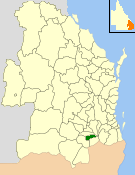
The Shire of Jondaryan was a local government area located in the Darling Downs region of Queensland, Australia, immediately west of the regional city of Toowoomba. The shire, administered from the town of Oakey, covered an area of 1,910.0 square kilometres (737.5 sq mi), and existed as a local government entity from 1890 until 2008, when it amalgamated with several other councils in the Toowoomba area to form the Toowoomba Region. Its growth in later years has been fuelled by the expansion of Toowoomba and suburbs such as Glenvale and Westbrook.

The Shire of Perry was a local government area in the northern catchment of the Burnett River, Queensland, Australia. The Shire covered an area of 2,357.7 square kilometres (910.3 sq mi), and existed as a local government area from 1880 until 2008, when it amalgamated with several other shires to form the North Burnett Region.
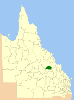
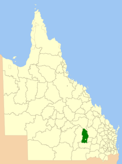
The Shire of Peak Downs was a local government area in the Central Highlands of Queensland, Australia, 320 km west of both Rockhampton and Mackay. On 15 March 2008 the shires of Duaringa, Emerald, Bauhinia and Peak Downs were amalgamated to form the Central Highlands Region.

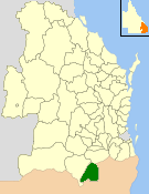
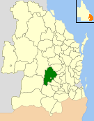
The Shire of Bauhinia was a local government area in Central Queensland, Queensland, Australia. The Shire, administered from the town of Springsure, covered an area of 23,649.6 square kilometres (9,131.2 sq mi), and existed as a local government entity from 1879 until 2008, when it was amalgamated with the Shires of Duaringa, Emerald and Peak Downs to form the Central Highlands Region.

The Shire of Taroom was a local government area in the Darling Downs region of Queensland, Australia, along the Leichhardt Highway to the north of Miles. The shire covered an area of 18,644.5 square kilometres (7,198.7 sq mi), and existed as a local government area from 1879 until 2008, when it was dissolved and split between the new Western Downs Region and the Shire of Banana.

The Shire of Murilla was a local government area located in the Darling Downs region of Queensland, Australia. The shire, administered from the town of Miles, covered an area of 6,075.8 square kilometres (2,345.9 sq mi), and existed as a local government entity from 1879 until 2008, when it amalgamated with the Town of Dalby and the Shires of Chinchilla, Tara and Wambo and the southern part of Taroom to form the Western Downs Region.
The Shire of Wambo was a local government area in the Darling Downs region of Queensland, Australia. The shire completely surrounded but did not include the town of Dalby — which had its own municipal government. It covered an area of 5,709.7 square kilometres (2,204.5 sq mi), and existed as a local government entity from 1879 until 2008, when it amalgamated with the Town of Dalby and the Shires of Chinchilla, Murilla and Tara and the southern part of Taroom to form the Western Downs Region.
The Shire of Bungil was a local government area in the Maranoa region of Queensland, Australia. It existed from 1880 to 2008.

The Shire of Tambo was a local government area located in central Queensland south-east of the town of Blackall. It covered an area of 14,083.8 square kilometres (5,437.8 sq mi), and existed as a local government entity from 1881 until 2008, when it amalgamated with neighbouring Shire of Blackall to form the Blackall-Tambo Region.

The Shire of Blackall was a local government area located in central Queensland around the town of Blackall. It covered an area of 16,366.8 square kilometres (6,319.3 sq mi), and existed as a local government entity from 1879 until 2008, when it amalgamated with neighbouring Shire of Tambo to form the Blackall-Tambo Region.

The Shire of Boonah was a local government area in South East Queensland, Australia, about 80 kilometres (50 mi) southwest of Brisbane. The shire covered an area of 1,921.6 square kilometres (741.9 sq mi), and existed from 1880 until its merger with parts of the Shire of Beaudesert and City of Ipswich to form the Scenic Rim Region on 15 March 2008.

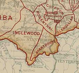
The Shire of Inglewood was a local government area of Queensland, Australia on the Queensland-New South Wales border in the Darling Downs region, about halfway between the towns of Goondiwindi and Warwick. Administered from the town of Inglewood, it covered an area of 5,876.7 square kilometres (2,269.0 sq mi), and existed as a local government entity from 1879 until 2008, when it amalgamated with the Shire of Waggamba and the Town of Goondiwindi to form the Goondiwindi Region.
The Shire of Warwick was a local government area in the Darling Downs region of Queensland, Australia. The administrative centre and major town of the shire was the town of Warwick.

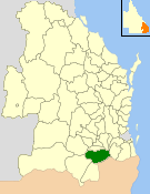
The Shire of Clifton was a local government area in the Darling Downs region of Queensland, Australia, southwest of the regional city of Toowoomba. The shire, administered from the town of Clifton, covered an area of 867.5 square kilometres (334.9 sq mi), and existed as a local government entity from 1879 until 2008, when it amalgamated with several other councils in the Toowoomba area to form the Toowoomba Region.

The Southern Downs Region is a local government area in the Darling Downs region of Queensland, Australia, along the state's boundary with New South Wales. It was created in 2008 from a merger of the Shire of Warwick and the Shire of Stanthorpe.
The Shire of Allora was a local government area north of the regional centre of Warwick in the Darling Downs region of Queensland. The shire, administered from Allora, covered an area of 702.0 square kilometres (271.0 sq mi), and existed as a local government entity from 1869 until 1994, when it was dissolved and amalgamated with City of Warwick, Shire of Rosenthal and Shire of Glengallan to form the Shire of Warwick.
The Shire of Glengallan was a local government area south and east of the regional centre of Warwick in the Darling Downs region of Queensland. The shire, administered from Warwick, covered an area of 1,699.6 square kilometres (656.2 sq mi), and existed as a local government entity from 1879 until 1994, when it was dissolved and amalgamated with City of Warwick, Shire of Rosenthal and Shire of Allora to form the Shire of Warwick.

The Shire of Rosenthal was a local government area south and west of the regional centre of Warwick in the Darling Downs region of Queensland. The shire, administered from Rosenthal Heights, a Warwick suburb, covered an area of 1,984.1 square kilometres (766.1 sq mi), and existed as a local government entity from 1886 until 1994, when it was dissolved and amalgamated with City of Warwick, Shire of Allora and Shire of Glengallan to form the Shire of Warwick.
The Ballandean Division was a local government area on the Granite Belt, Queensland, Australia, close to the Queensland-New South Wales border. It only existed between 1879 and 1880.