
The Town of Hamilton is a former local government area of Queensland, Australia, located in north-eastern Brisbane.
The Town of Hamilton is a former local government area of Queensland, Australia, located in north-eastern Brisbane.

The Divisional Boards Act 1879 established Divisional Boards as a form of local government for area outside the boundaries of recognised municipalities. The Kedron Division was one of those initially established on 11 November 1879, [1] but on 3 November 1883 the Toombul Division was separated from the Kedron Division. [2] Following agitation by Toombul board member Andrew Lang Petrie, the Hamilton Division was then separated from the Toombul Division on 2 October 1890 and Petrie become its first chairman. [3] [4] [5]
In 1902, the Local Authorities Act 1902 replaced all divisions with towns and shires, creating the Shire of Hamilton on 31 March 1903. [3] [6]
In 1904, it was proclaimed the Town of Hamilton. [6] [7]
In 1925, it was amalgamated into the City of Brisbane. [7]
The Hamilton Town Hall was built in 1920 and is located at the north-west corner of the intersection of Racecourse Road and Rossiter Street, Hamilton. After the amalgamation into the City of Brisbane, the Hamilton Town Hall was used as a School of Arts. In World War II it was used by the Australian Army. After the war, the Hamilton branch of the Brisbane City Council library was located in the building, a role which continues to the present day. There are also meeting rooms available for use by community groups. [8] [9]
The town hall was listed on the Queensland Heritage Register in 2005. [10]

The list of chairmen (to 1902) and mayors (1903–1925) include:

The Town of Windsor is a former local government area of Queensland, Australia, located in northern Brisbane.

Nundah is an inner suburb in the City of Brisbane, Queensland, Australia. It contains the neighbourhood of Toombul. In the 2016 census, Nundah had a population of 12,141 people.

Kalinga is a suburb in the City of Brisbane, Queensland, Australia. In the 2016 census, Kalinga had a population of 2,126 people.

The City of Redcliffe is a former local government area in South East Queensland, Australia. In 2008 it was amalgamated with the Shires of Pine Rivers and Caboolture to create Moreton Bay Region, later renamed City of Moreton Bay. It is in the northern part of the County of Stanley, with a total area of 38.1 square kilometres (14.7 sq mi) and a population of 51,174 in the 2006 census.

The Town of Brisbane was a local government area for Brisbane in Queensland, Australia from 1859 to 1903.

Andrew Lang Petrie was a builder, stonemason and politician in Queensland, Australia. He was a Member of the Queensland Legislative Assembly.
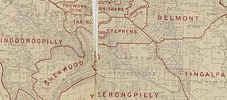
The Shire of Stephens was a local government area in the inner southern suburbs of Brisbane, Queensland, Australia. The shire, administered from Annerley, covered an area of 9 square miles (23 km2), and existed as a local government entity from 1886 until 1925, when it was amalgamated into the City of Brisbane under the City of Brisbane Act 1924.
The Shire of Tingalpa was a local government area in the south-eastern suburbs of Brisbane, Queensland, Australia. The shire, administered from Mount Cotton, covered an area of 120 square miles (311 km2), and existed as a local government entity from 1879 until 1949.

The City of South Brisbane was a local government area on the southern side of the Brisbane River, Queensland, Australia. It was established in 1888 and existed until 1925 when it was amalgamated into the City of Brisbane.
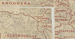
The Town of Toowong is a former local government area of Queensland, Australia, located in western Brisbane in the area around the current suburb of Toowong.

The Shire of Balmoral is a former local government area of Queensland, Australia, located in eastern Brisbane.
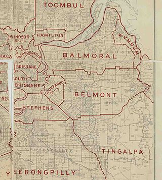
The Shire of Belmont is a former local government area of Queensland, Australia, located in eastern Brisbane including the current suburb of Belmont.

The Shire of Coorparoo is a former local government area of Queensland, Australia, located in eastern Brisbane.

The Shire of Enoggera is a former local government area of Queensland, Australia, located in north-western Brisbane.
The Shire of Kedron is a former local government area of Queensland, Australia, located in northern Brisbane. It existed between 1879 and 1925.

The Kedron Division is a former local government area of Queensland, Australia, located in northern Brisbane.

The Shire of Toombul was a local government area of Queensland, Australia, located in northern Brisbane from 1883 to 1925.

The Shire of Moggill is a former local government area of Queensland, Australia, located in western Brisbane.

The Shire of Taringa is a former local government area of Queensland, Australia, located in western Brisbane. Its administrative centre was Taringa. It existed from 1890 to 1925.

The City of Gympie is a former local government area in the south-east of Queensland, Australia, responsible for governing Gympie.