City of Mackay

Last updated

City of Mackay
Queensland
Mackay LGA Qld.png
Location within Queensland
Population84,890 (2006) [1]
 • Density29.2977/km2 (75.881/sq mi)
Established1869
Area2,897.5 km2 (1,118.7 sq mi)
Council seat Mackay
Region Central Queensland
Mackay city council.svg
Website City of Mackay
LGAs around City of Mackay:
Bowen Whitsunday Pacific Ocean
Mirani City of MackayPacific Ocean
Nebo Sarina Pacific Ocean

The City of Mackay was a local government area located in the Central Queensland region of Queensland, Australia, encompassing the regional city of Mackay and the surrounding region. The City was created as a municipal borough in 1869, and prior to amalgamation with the Shire of Pioneer in 1994, the City was limited to the central suburbs on the south shore of the Pioneer River. From 1994 until 2008, the City covered an area of 2,897.5 square kilometres (1,118.7 sq mi). In 2008, it amalgamated with the Shires of Mirani and Sarina to become the Mackay Regional Council.

Contents

History

The Borough of Mackay was proclaimed on 22 September 1869 under the Municipal Institutions Act 1864. [2] The Pioneer Division was established on 11 November 1879 as one of 74 founding divisions under the Divisional Boards Act 1879.

Initially the council meetings were held in the Court House in River Street, the Post and Telegraph office in Wood Street, and in a building on Sydney Street owned by Mr R. Fleming. The first town hall was a timber structure constructed in 1872 on land that the council purchased at 63 Sydney Street. [3]

With the passage of the Local Authorities Act 1902, Pioneer Division became the Shire of Pioneer and Mackay became Town of Mackay on 31 March 1903. Mackay received City status on 17 August 1918.

Second Mackay Town Hall, built in 1912, as seen in 2008 Mackay QLD, Town Hall 1912.jpg
Second Mackay Town Hall, built in 1912, as seen in 2008

During the boom in sugar prices, the borough council decided in 1884 that a larger town hall was needed. However, it was not until 1909 that they decided to proceed with a brick building on the site of the existing town hall in Sydney Street. The council held a design competition, which was won by a local architect and engineer Arthur Rigby. The first town hall was moved to the rear of the block to be behind the new building. The first official Council meeting was held in the (now heritage-listed) second town hall on 19 October 1912 with the official opening the next day. [3]

Mackay Civic Administration Building, Gordon Street, Mackay Mackay council.jpg
Mackay Civic Administration Building, Gordon Street, Mackay

After the council moved into their new Civic Administration Centre in 1974, they proposed to demolish the town hall and sell off the land to defray the costs of the new civic centre. However, following public protest, they renovated the building to make it available for community purposes. [3]

On 21 November 1991, the Electoral and Administrative Review Commission, created two years earlier, produced its second report, and recommended that local government boundaries in the Mackay area be rationalised. The Local Government (Mackay and Pioneer) Regulation 1993 was gazetted on 17 December 1993, and on 30 March 1994, the two amalgamated into a larger City of Mackay, which first met on 8 April 1994.

On 15 March 2008, under the Local Government (Reform Implementation) Act 2007 passed by the Parliament of Queensland on 10 August 2007, the City of Mackay merged with the Shires of Mirani and Sarina to form the Mackay Regional Council.

Towns and localities

Prior to 1994, Mackay consisted of the suburbs of North Mackay, West Mackay, South Mackay and East Mackay.

All other suburbs of Mackay belonged into the defunct Shire of Pioneer.

After the amalgamation, the City of Mackay included the following settlements:

Mayors

Amalgamation of Mackay City and Pioneer Shire Councils

Amalgamation of Mackay City Sarina Shire and Mirani Shire Councils

Town Clerks

The town clerks of the City of Mackay were:

Transport

Sister cities

Population

YearPopulation
(Mackay)
Population
(Pioneer)
Population
(Total)
193310,6659,92620591
194713,48611,60625092
195414,76214,31629,078
196116,80915,74132,550
196618,64019,90038,540
197119,14822,56141,709
197620,22426,93847,162
198120,66433,73254,396
198622,19936,08458,283
199123,05240,61463,666
199671,894
200175,020
200620,80385,399
2015120,000

Related Research Articles

<span class="mw-page-title-main">Mackay, Queensland</span> City in Queensland, Australia

Mackay is a city in the Mackay Region on the eastern or Coral Sea coast of Queensland, Australia. It is located about 970 kilometres (603 mi) north of Brisbane, on the Pioneer River. Mackay is described as being in either Central Queensland or North Queensland, as these regions are not precisely defined. More generally, the area is known as the Mackay–Whitsunday Region. Nicknames of Mackay include the Sugar capital and Macktown.

<span class="mw-page-title-main">Shire of Pine Rivers</span> Local government area in Queensland

The Shire of Pine Rivers was a local government area about 20 kilometres (12 mi) north of Brisbane in the Moreton Bay region of South East Queensland, Australia. The shire covered an area of 771 square kilometres (297.7 sq mi), and existed as a local government entity from 1888 until 2008, when it amalgamated with councils further north and east to form the Moreton Bay Region.

<span class="mw-page-title-main">Shire of Fitzroy</span> Local government area in Queensland, Australia

The Shire of Fitzroy was a local government area located in the Capricornia region of Central Queensland, Queensland, Australia, to the immediate west and south of the regional city of Rockhampton. The shire, administered from the town of Gracemere, covered an area of 5,898.7 square kilometres (2,277.5 sq mi), and existed as a local government entity from 1899 until 2008, when it amalgamated with several other councils to become the Rockhampton Region. It is named for the Fitzroy River, that passes along the northern boundary of the shire.

<span class="mw-page-title-main">Shire of Taroom</span> Local government area in Queensland, Australia

The Shire of Taroom was a local government area in the Darling Downs region of Queensland, Australia, along the Leichhardt Highway to the north of Miles. The shire covered an area of 18,644.5 square kilometres (7,198.7 sq mi), and existed as a local government area from 1879 until 2008, when it was dissolved and split between the new Western Downs Region and the Shire of Banana.

<span class="mw-page-title-main">Shire of Barcaldine</span> Local government area in Queensland, Australia

The Shire of Barcaldine was a local government area located in central Queensland and headquartered in the town of Barcaldine. It covered an area of 8,448.4 square kilometres (3,261.9 sq mi), and existed as a local government entity from 1892 until 2008, when it amalgamated with the Shires of Aramac and Jericho to form the Barcaldine Region.

<span class="mw-page-title-main">Shire of Sarina</span> Local government area in Queensland, Australia

The Shire of Sarina was a local government area located in the Central Queensland region of Queensland, Australia. The shire, administered from the town of Sarina, covered an area of 1,444.3 square kilometres (557.6 sq mi), and existed as a local government entity from 1912 until 2008, when it amalgamated with the City of Mackay and the Shire of Mirani to form the Mackay Region.

<span class="mw-page-title-main">Shire of Mirani</span> Local government area in Queensland, Australia

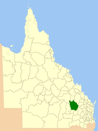
The Shire of Mirani was a local government area located in the North Queensland region of Queensland, Australia. The shire, administered from the town of Mirani, covered an area of 3,280.2 square kilometres (1,266.5 sq mi), and existed as a local government entity from 1916 until 2008, when it amalgamated with the City of Mackay and the Shire of Sarina to form the Mackay Region.

<span class="mw-page-title-main">Shire of Woocoo</span> Local government area in Queensland, Australia

The Shire of Woocoo was a local government area located in the Wide Bay–Burnett region of Queensland, Australia, containing the rural residential area to the west of the town of Maryborough, and surrounding countryside. The shire covered an area of 2,007.9 square kilometres (775.3 sq mi), and existed as a local government entity from 1914 until 2008, when it was amalgamated with the City of Maryborough, City of Hervey Bay and the 1st and 2nd divisions of the Shire of Tiaro to form the Fraser Coast Region.

<span class="mw-page-title-main">City of Rockhampton</span> Local government area in Queensland, Australia

The City of Rockhampton is a local government area in the Central Queensland region of Queensland, Australia, encompassing most of the suburban area of the regional city of Rockhampton. The city covered an area of 188.7 square kilometres (72.9 sq mi), and has existed as a local government entity in various forms from 1860 until 2008, when it amalgamated with several other councils in the surrounding area to become the Rockhampton Region.

<span class="mw-page-title-main">Mackay Region</span> Local government area in Queensland, Australia

The Mackay Region is a local government area located in North Queensland, Queensland, Australia. Established in 2008, it was preceded by three previous local government areas with modern histories extending back as far as 1869.

<span class="mw-page-title-main">City of Ararat</span> Local government area in Victoria, Australia

The City of Ararat was a local government area about 200 kilometres (124 mi) west-northwest of Melbourne, the state capital of Victoria, Australia. It existed from 1858 until 1994.

<span class="mw-page-title-main">Shire of Pioneer</span> Local government area in Queensland, Australia

The Shire of Pioneer was a local government area surrounding the city of Mackay and including all but its innermost suburbs. The shire, administered from Mackay itself, covered an area of 2,820.1 square kilometres (1,088.8 sq mi), and existed as a local government entity from 1879 until 1994, when it was dissolved and amalgamated with City of Mackay.

<span class="mw-page-title-main">Shire of Allora</span> Local government area in Queensland, Australia

The Shire of Allora was a local government area north of the regional centre of Warwick in the Darling Downs region of Queensland. The shire, administered from Allora, covered an area of 702.0 square kilometres (271.0 sq mi), and existed as a local government entity from 1869 until 1994, when it was dissolved and amalgamated with City of Warwick, Shire of Rosenthal and Shire of Glengallan to form the Shire of Warwick.

<span class="mw-page-title-main">City of Warwick</span> Local government area in Queensland, Australia

The City of Warwick was a local government area administering the regional centre of Warwick in the Darling Downs region of Queensland. The City covered an area of 25.1 square kilometres (9.7 sq mi), and existed as a local government entity from 1861 until 1994, when it was dissolved and amalgamated with Shire of Allora, Shire of Rosenthal and Shire of Glengallan to form the Shire of Warwick.

<span class="mw-page-title-main">Mirani, Queensland</span> Town in Queensland, Australia

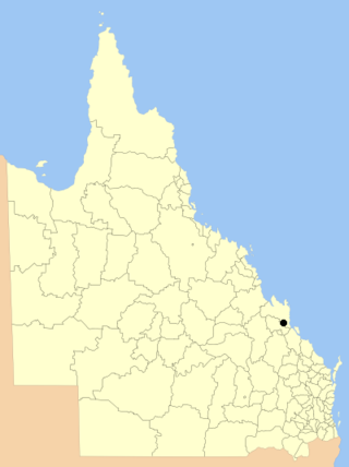
Mirani is a rural town and locality in the Mackay Region, Queensland, Australia. In the 2016 census, the locality of Mirani had a population of 1,541 people.

<span class="mw-page-title-main">Town of Southport</span>

The Town of Southport was a local government area in South East Queensland, Australia.

<span class="mw-page-title-main">City of Gympie</span>

The City of Gympie is a former local government area in the south-east of Queensland, Australia, responsible for governing Gympie.

<span class="mw-page-title-main">Finch Hatton railway station</span> Historic site in Queensland, Australia

Finch Hatton railway station is a heritage-listed former railway station at Mackay-Eungella Road, Finch Hatton, Mackay Region, Queensland, Australia. It was built in 1904. It is also known as Hatton railway station and Pelion railway station. It was added to the Queensland Heritage Register on 6 December 2004.

<span class="mw-page-title-main">Pioneer Shire Council Building</span> Historic site in Queensland, Australia

Pioneer Shire Council Building is a heritage-listed town hall at 1 Wood Street, Mackay, Mackay Region, Queensland, Australia. It was designed by Harold Vivian Marsh Brown and built in 1935 by William Patrick Guthrie. It was added to the Queensland Heritage Register on 7 December 2007.

Mackay–Eungella Road is a continuous 69.7 kilometres (43.3 mi) road route in the Mackay region of Queensland, Australia. The entire route is signed as State Route 64. It is a state-controlled regional road . At the western end it becomes Eungella Dam Road.

References

  1. Australian Bureau of Statistics (25 October 2007). "Mackay (C) (Local Government Area)". 2006 Census QuickStats. Retrieved 16 April 2015.
  2. "Agency ID 10385, Mackay Municipal Council". Queensland State Archives . Retrieved 22 January 2014.
  3. 1 2 3 "Mackay Town Hall (former) (entry 601107)". Queensland Heritage Register . Queensland Heritage Council. Retrieved 22 January 2014.
  4. 1 2 3 4 5 6 7 8 9 10 11 12 13 14 15 16 17 18 19 20 21 22 23 24 25 26 27 28 29 30 31 32 33 34 35 36 37 38 39 40 41 42 43 44 45 46 47 48 49 50 51 52 53 54 55 56 57 58 59 60 61 62 63 64 65 66 67 68 69 70 71 72 73 74 75 76 77 78 79 80 81 82 83 84 85 86 87 88 Wright, Berenice D; Mackay. Libraries. Local History Section (2009). Mackay City Council representatives : '1869-2008'. Mackay City Council. Archived from the original on 23 December 2020. Retrieved 13 November 2017.
  5. Australian History Publishing Co (1936), Queensland and Queenslanders : incorporating 'Prominent Queenslanders', Australian History Publishing Co, p. 299, archived from the original on 2 October 2015, retrieved 1 October 2015 — available online Archived 16 February 2017 at the Wayback Machine
  6. Pugh, Theophilus Parsons (1927). Pugh's Almanac for 1927. Archived from the original on 4 March 2014. Retrieved 13 June 2014.
  7. "Pioneer Shire Council Building (former) (entry 602603)". Queensland Heritage Register . Queensland Heritage Council. Retrieved 1 August 2014.

Coordinates: 21°08′28.31″S149°11′08.26″E / 21.1411972°S 149.1856278°E / -21.1411972; 149.1856278