The Shire of Livingstone is a local government area located in the Capricornia region of Central Queensland, Queensland, Australia, to the immediate north and east of the regional city of Rockhampton. The shire, administered from the coastal town of Yeppoon, covers an area of 11,758 square kilometres (4,539.8 sq mi), and existed as a local government entity from 1879 until 2008, when it amalgamated with several other councils to become the Rockhampton Region. The Shire was re-established on 1 January 2014 following a successful de-amalgamation referendum in 2013.

Allora is a rural town and locality in the Southern Downs Region, Queensland, Australia. In the 2016 census, the locality of Allora had a population of 1,223 people.
The Shire of Burnett was a local government area located in the Wide Bay–Burnett region of Queensland, Australia. It surrounded, but did not include, the regional city of Bundaberg, and covered an area of 2,000.8 square kilometres (772.5 sq mi). It existed as a local government entity from its creation through the amalgamation of the Shire of Gooburrum and the Shire of Woongarra in 1994 until 2008, when it amalgamated with the City of Bundaberg and other councils in the region to form the Bundaberg Region.

The Shire of Murilla was a local government area located in the Darling Downs region of Queensland, Australia. The shire, administered from the town of Miles, covered an area of 6,075.8 square kilometres (2,345.9 sq mi), and existed as a local government entity from 1879 until 2008, when it amalgamated with the Town of Dalby and the Shires of Chinchilla, Tara and Wambo and the southern part of Taroom to form the Western Downs Region.
The Shire of Wambo was a local government area in the Darling Downs region of Queensland, Australia. The shire surrounded but did not include the town of Dalby – which had its own municipal government. It covered an area of 5,709.7 square kilometres (2,204.5 sq mi), and existed as a local government entity from 1879 until 2008, when it amalgamated with the Town of Dalby and the Shires of Chinchilla, Murilla and Tara and the southern part of Taroom to form the Western Downs Region.
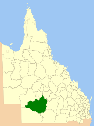
The Shire of Quilpie is a local government area in South West Queensland, Australia. It covers an area of 67,415 square kilometres (26,029 sq mi), and its administrative centre is the town of Quilpie.

The Shire of Bulloo is a local government area in South West Queensland, Australia.
The Shire of Cooloola was a local government area located about 170 kilometres (106 mi) north of Brisbane – the state capital of Queensland, Australia. The shire covered an area of 2,968.8 square kilometres (1,146.3 sq mi), and was the product of a merger in 1993 between the City of Gympie and the Shire of Widgee, which had both existed since 1879–1880. It merged with several other LGAs to form the Gympie Region on 15 March 2008.

The Shire of Clifton was a local government area in the Darling Downs region of Queensland, Australia, southwest of the regional city of Toowoomba. The shire, administered from the town of Clifton, covered an area of 867.5 square kilometres (334.9 sq mi), and existed as a local government entity from 1879 until 2008, when it amalgamated with several other councils in the Toowoomba area to form the Toowoomba Region.

The Bundaberg Region is a local government area in the Wide Bay–Burnett region of Queensland, Australia, about 360 kilometres (220 mi) north of Brisbane, the state capital. It is centred on the city of Bundaberg, and also contains a significant rural area surrounding the city. It was created in 2008 from a merger of the City of Bundaberg with the Shires of Burnett, Isis and Kolan.
The Southern Downs Region is a local government area in the Darling Downs region of Queensland, Australia, along the state's boundary with New South Wales. It was created in 2008 from a merger of the Shire of Warwick and the Shire of Stanthorpe.
The Shire of Moreton was a local government area in South East Queensland, Australia, located about 50 kilometres (31 mi) southwest of Queensland's capital, Brisbane. It represented an area surrounding but not including Ipswich, and existed from 1917 until 1995, when it merged into the City of Ipswich, City of Brisbane, and Shire of Esk.

The Shire of Pioneer was a local government area surrounding the city of Mackay and including all but its innermost suburbs. The shire, administered from Mackay itself, covered an area of 2,820.1 square kilometres (1,088.8 sq mi), and existed as a local government entity from 1879 until 1994, when it was dissolved and amalgamated with City of Mackay.
The Shire of Albert was a local government area in Queensland, located south of the capital, Brisbane, and taking in areas to the north and west of the Gold Coast. It was named after the Prince Consort of the United Kingdom, and husband of Queen Victoria, Prince Albert. When created in 1948, it was primarily a rural area, but its growth started in earnest in the late 1960s with the development of Logan on Brisbane's southern frontier. After the separate creation of Logan as a shire in 1978, Albert lost most of its population and became more centred upon the Gold Coast, which experienced a massive period of growth from then until the Shire's amalgamation with the City of Gold Coast in 1995.
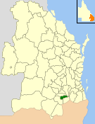
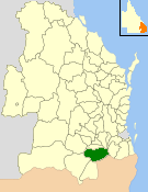
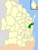
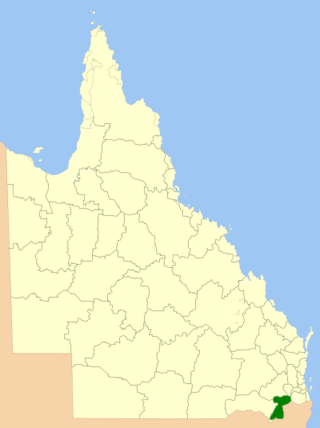
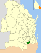
The Shire of Allora was a local government area north of the regional centre of Warwick in the Darling Downs region of Queensland. The shire, administered from Allora, covered an area of 702.0 square kilometres (271.0 sq mi), and existed as a local government entity from 1869 until 1994, when it was dissolved and amalgamated with City of Warwick, Shire of Rosenthal and Shire of Glengallan to form the Shire of Warwick.
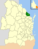
The Shire of Glengallan was a local government area south and east of the regional centre of Warwick in the Darling Downs region of Queensland. The shire, administered from Warwick, covered an area of 1,699.6 square kilometres (656.2 sq mi), and existed as a local government entity from 1879 until 1994, when it was dissolved and amalgamated with City of Warwick, Shire of Rosenthal and Shire of Allora to form the Shire of Warwick.

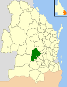
The Shire of Rosenthal was a local government area south and west of the regional centre of Warwick in the Darling Downs region of Queensland. The shire, administered from Rosenthal Heights, a Warwick suburb, covered an area of 1,984.1 square kilometres (766.1 sq mi), and existed as a local government entity from 1886 until 1994, when it was dissolved and amalgamated with City of Warwick, Shire of Allora and Shire of Glengallan to form the Shire of Warwick.

The City of Warwick was a local government area administering the regional centre of Warwick in the Darling Downs region of Queensland. The City covered an area of 25.1 square kilometres (9.7 sq mi), and existed as a local government entity from 1861 until 1994, when it was dissolved and amalgamated with Shire of Allora, Shire of Rosenthal and Shire of Glengallan to form the Shire of Warwick.

The City of Gympie is a former local government area in the south-east of Queensland, Australia, responsible for governing Gympie.
The Electoral and Administrative Review Commission (1989–1993) was an agency of the Government of Queensland, Australia to investigate the electoral system and public administration of the state and local government authorities of Queensland.