Shutdown Mountain (Maine)

Last updated
Shutdown Mountain
USA Maine location map.svg
Red triangle with thick white border.svg
Shutdown Mountain
Highest point
Elevation 2,539 ft (774 m)
Prominence 939 ft (286 m) [1]
Coordinates 45°25′03″N70°11′58″W / 45.417521°N 70.199397°W / 45.417521; -70.199397 Coordinates: 45°25′03″N70°11′58″W / 45.417521°N 70.199397°W / 45.417521; -70.199397
Geography
Location Somerset County, Maine, U.S.
Topo map USGS Enchanted Pond

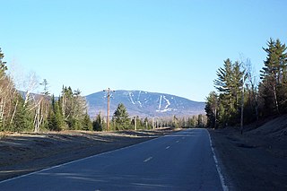
Shutdown Mountain is a mountain located in Somerset County, Maine. [2]

Mountain A large landform that rises fairly steeply above the surrounding land over a limited area

A mountain is a large landform that rises above the surrounding land in a limited area, usually in the form of a peak. A mountain is generally steeper than a hill. Mountains are formed through tectonic forces or volcanism. These forces can locally raise the surface of the earth. Mountains erode slowly through the action of rivers, weather conditions, and glaciers. A few mountains are isolated summits, but most occur in huge mountain ranges.

Somerset County, Maine county in Maine, United States

Somerset County is a county in the state of Maine, in the United States. As of the 2010 census, the population was 52,228. Its county seat is Skowhegan.

Maine State of the United States of America

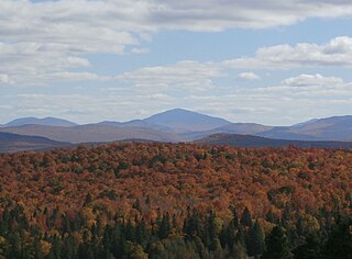
Maine is a state in the New England region of the northeastern United States. Maine is the 12th smallest by area, the 9th least populous, and the 38th most densely populated of the 50 U.S. states. It is bordered by New Hampshire to the west, the Atlantic Ocean to the southeast, and the Canadian provinces of New Brunswick and Quebec to the northeast and northwest respectively. Maine is the easternmost state in the contiguous United States, and the northernmost state east of the Great Lakes. It is known for its jagged, rocky coastline; low, rolling mountains; heavily forested interior; and picturesque waterways, as well as its seafood cuisine, especially lobster and clams. There is a humid continental climate throughout most of the state, including in coastal areas such as its most populous city of Portland. The capital is Augusta.

Shutdown Mountain lies within the watershed of the Kennebec River and has two peaks, Shutdown Peak and Bulldog Peak (elevation 2260 ft.), sometimes referred to as Bulldog Mountain. The northern and southern sides of Shutdown Mountain drain into Enchanted Stream, then into the Dead River, a tributary of the Kennebec River. The west side of Shutdown drains into Stony Brook, then into the Dead River. The east side drains into Enchanted Pond, then into Enchanted Stream and into the Dead River.

Drainage basin Area of land where precipitation collects and drains off into a common outlet

A drainage basin is any area of land where precipitation collects and drains off into a common outlet, such as into a river, bay, or other body of water. The drainage basin includes all the surface water from rain runoff, snowmelt, and nearby streams that run downslope towards the shared outlet, as well as the groundwater underneath the earth's surface. Drainage basins connect into other drainage basins at lower elevations in a hierarchical pattern, with smaller sub-drainage basins, which in turn drain into another common outlet.

Kennebec River river in Maine, United States

The Kennebec River is a 170-mile-long (270 km) river within the U.S. state of Maine.

Tributary stream or river that flows into a main stem river or lake

A tributary or affluent is a stream or river that flows into a larger stream or main stem river or a lake. A tributary does not flow directly into a sea or ocean. Tributaries and the main stem river drain the surrounding drainage basin of its surface water and groundwater, leading the water out into an ocean.

There is a marked hiking trail (called "Enchanted Lookout") to the top of Bulldog Peak which has a prominence of 817 ft. overlooking Enchanted. The trailhead is located at Bulldog Camps, a traditional Maine sporting camp on the north shore of Enchanted Pond. [3]

Bulldog Camps sporting camp in Maine, United States

Bulldog Camps on Enchanted Pond is a traditional remote Maine sporting camp in the western mountains that has attracted visitors for over a century. Located in Upper Enchanted Township, near Jackman, Maine, United States, the camps were established by Henry Patrick McKenney in the 1880s as a set of logging camps, were converted into an active sporting camp in the early 1900s, and remain a current member of the Maine Sporting Camp Association.

Sporting camp

A sporting camp is an establishment that provides lodging, meals and guide service for hunting, fishing, and outdoor recreation and usually consists of a set of “camps” or cabins accompanied by a main lodge. Some also offer primitive outpost cabins. Traditionally found in forests and on lakes in remote locations throughout the state of Maine, sporting camps are a popular lodging destination that have offered a unique outdoors experience to sportsmen across New England and throughout the United States for over a century.

Related Research Articles

Mount Crescent is a mountain located in the Crescent Range of the White Mountains in Randolph, New Hampshire. It is 3,251 ft (991 m) high, and its summit is the second highest mountain summit in Randolph, after Black Crescent Mountain. Both mountains are in Randolph's Ice Gulch Town Forest. On the 1896 topographic map, Mount Crescent is shown as "Randolph Mtn." with an elevation of 3,280 ft, and Black Crescent is shown as "Mt. Crescent" with an elevation of 3,322 ft.

Crocker Mountain (Maine) mountain in United States of America

Crocker Mountain is a 4,228 ft (1,289 m) peak located in Carrabassett Valley, Franklin County, Maine, in the United States. Crocker Mountain is the fourth highest mountain in the state after the Katahdins and Sugarloaf Mountain, and is part of the Appalachian Mountains. Crocker Mountain is traversed by the Appalachian Trail (AT), a 2,170 mi (3,490 km) National Scenic Trail from Georgia to Maine.

Saddleback Mountain (Rangeley, Maine)

Saddleback Mountain is a mountain located in Sandy River Plantation, Franklin County, Maine, near the resort town of Rangeley. Saddleback is one of the highest mountains in the State of Maine, and one of the fourteen with more than 2,000 ft (610 m) of topographic prominence. The mountain is the site of Saddleback ski resort.

Sugarloaf Mountain (Franklin County, Maine) mountain located in Franklin County, Maine

Sugarloaf Mountain is a mountain located in Carrabassett Valley, Franklin County, Maine. It is the third highest peak in the state, after Mount Katahdin's Baxter and Hamlin peaks. Sugarloaf is flanked to the south by Spaulding Mountain.

Spaulding Mountain mountain in United States of America

Spaulding Mountain is a mountain located in Franklin County, Maine. Spaulding Mountain is flanked to the northeast by Sugarloaf Mountain, and to the southeast by Mount Abraham.

Coburn Mountain (Maine) mountain in United States of America

Coburn Mountain is a mountain located in Somerset County, Maine.

Snow Mountain (Franklin County, Maine)

Snow Mountain is a mountain located in Franklin County, Maine, about 5 mi (8 km) from the Canada–United States border. Snow Mtn. is flanked to the northeast by Bag Pond Mountain, and to the southeast by Round Mountain.

Traveler Mountain mountain in United States of America

Traveler Mountain is a mountain located in Piscataquis County, Maine, in Baxter State Park. The Traveler, is the eighth-most prominent in Maine. Subsidiary peaks include the Peak of the Ridges 3,225 ft (983 m) North and South Traveler Mountain 3,144 ft (958 m) and 2,677 ft (816 m), respectively.

Kibby Mountain mountain in United States of America

Kibby Mountain is a mountain located in Franklin County, Maine, about 3.5 mi (5.6 km) east of the Canada–United States border. Kibby Mountain is flanked to the southeast by Spencer Bale Mountain.

Baldpate Mountain (Maine)

Baldpate Mountain is a mountain located in Oxford County, Maine. Baldpate has two prominent peaks; West Peak has 3,662 feet (1,116 m) of elevation, and stands 222 feet (68 m) above the col between them.

Elephant Mountain (Oxford County, Maine)

Elephant Mountain is a mountain located in Township C, Oxford County, Maine. Its northeastern end is in Township D, Franklin County. Elephant Mountain is flanked to the northeast by Bemis Mountain, and to the southeast by Old Blue Mountain.

Big Spencer Mountain mountain in United States of America

Big Spencer Mountain is a mountain located in Piscataquis County, Maine. Big Spencer Mtn. is flanked to the west by Little Spencer Mountain.

Moxie Mountain mountain in United States of America

Moxie Mountain is a mountain located in Somerset County, Maine.

Goose Eye Mountain mountain in United States of America

Goose Eye Mountain, also known as Mt. Goose High, is a mountain located in Oxford County, Maine, about 1 mi (1.6 km). (2 km) east of the New Hampshire-Maine border. The mountain is the second-highest peak of the Mahoosuc Range of the White Mountains.

Boundary Peak (Maine/Quebec)

This mountain, which has no formal name, is located on the Canada–US border between boundary markers 445 and 446. It is the highest point on the border east of the Rocky Mountains. Specifically it is the highest point for 3190 miles of border from the Passamquoddy Bay up to 111 degrees west in Liberty County, Montana at border monument 360 (miles) from the Pacific. The southeast half is in Oxford County, Maine; the northwest half is in Le Granit Regional County Municipality, Quebec, Canada.

West Kennebago Mountain mountain in United States of America

West Kennebago Mountain is a mountain located in Oxford County, Maine. West Kennebago is flanked to the north by Twin Mountains, and to the southwest by Burnt Mountain.

Saddleback Junior mountain in United States of America

Saddleback Junior is a mountain located in Franklin County, Maine. Saddleback Junior is flanked to the southwest by Saddleback Horn, and to the northeast by Poplar Ridge. The mountain is on the south border of the U.S. Navy Survival Escape and Evasion Training Facility (USSEAETF).

Noyes Mountain (Maine) mountain in United States of America

Noyes Mountain is a mountain located in Maine near the town of South Paris. It is named after George Lorenzo Noyes, who built and operated Harvard Quarry located nearby.

Enchanted Pond

Enchanted Pond is a mountain pond in the U.S. state of Maine. Situated in the Western Maine Mountains in the Northwest Somerset Region, the pond is located in a deep mountain valley between Coburn Mountain and Shutdown Mountain. Near its southern end, the pond is distinguished by two rockslides from the exposed cliffs of these mountains that extend down into the water along both shores. Enchanted Pond is fed by mountain springs and Little Enchanted Pond, and is the primary source of Enchanted Stream which flows into the Dead River, a tributary of the Kennebec River. Development on the pond is limited to a small set of sporting camps at the northern end of the pond and one remote camp on the southwest shore, both a part of Bulldog Camps. There are no islands in the pond.

References

See also