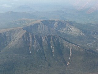
Traveler Mountain

Last updated
Traveler Mountain

Traveler Mountain.jpg

Traveler Mountain, from Lower South Branch Pond, to the northwest
Highest point
Elevation 3,540 ft (1,080 m)
Prominence 2,346 ft (715 m) [1]
Listing New England Fifty Finest #22
Coordinates 46°04′22″N68°50′41″W / 46.072833°N 68.844833°W / 46.072833; -68.844833 Coordinates: 46°04′22″N68°50′41″W / 46.072833°N 68.844833°W / 46.072833; -68.844833
Geography
USA Maine location map.svg
Red triangle with thick white border.svg
Traveler Mountain
Topo map USGS The Traveler

Traveler Mountain is a mountain located in Piscataquis County, Maine, in Baxter State Park. [2] The Traveler, is the eighth-most prominent in Maine. Subsidiary peaks include the Peak of the Ridges 3,225 ft (983 m) North and South Traveler Mountain 3,144 ft (958 m) and 2,677 ft (816 m), respectively. [3]

Mountain A large landform that rises fairly steeply above the surrounding land over a limited area

A mountain is a large landform that rises above the surrounding land in a limited area, usually in the form of a peak. A mountain is generally steeper than a hill. Mountains are formed through tectonic forces or volcanism. These forces can locally raise the surface of the earth. Mountains erode slowly through the action of rivers, weather conditions, and glaciers. A few mountains are isolated summits, but most occur in huge mountain ranges.

Piscataquis County, Maine County in the United States

Piscataquis County is a county located in the U.S. state of Maine. As of the 2010 census, its population was 17,535, making it Maine's least-populous county. Its county seat is Dover-Foxcroft. The county was incorporated on 23 March 1838, taken from the western part of Penobscot County and the eastern part of Somerset County, and is named for an Abenaki word meaning "branch of the river" or "at the river branch."
Maine State of the United States of America

Maine is a state in the New England region of the northeastern United States. Maine is the 12th smallest by area, the 9th least populous, and the 38th most densely populated of the 50 U.S. states. It is bordered by New Hampshire to the west, the Atlantic Ocean to the southeast, and the Canadian provinces of New Brunswick and Quebec to the northeast and northwest respectively. Maine is the easternmost state in the contiguous United States, and the northernmost state east of the Great Lakes. It is known for its jagged, rocky coastline; low, rolling mountains; heavily forested interior; and picturesque waterways, as well as its seafood cuisine, especially lobster and clams. There is a humid continental climate throughout most of the state, including in coastal areas such as its most populous city of Portland. The capital is Augusta.

The Traveler stands within the watershed of the Penobscot River, which drains into Penobscot Bay on the coast of Maine. The east side of the Traveler drains into the East Branch of the Penobscot River. The north and west sides of the Traveler drain by several brooks into Trout Brook, then into Grand Lake Matagamon, the source of the East Branch of the Penobscot. The south side of the Traveler drains into the Pogy Brook, then into Wassataquoik Stream and the East Branch.

Drainage basin Area of land where precipitation collects and drains off into a common outlet

A drainage basin is any area of land where precipitation collects and drains off into a common outlet, such as into a river, bay, or other body of water. The drainage basin includes all the surface water from rain runoff, snowmelt, and nearby streams that run downslope towards the shared outlet, as well as the groundwater underneath the earth's surface. Drainage basins connect into other drainage basins at lower elevations in a hierarchical pattern, with smaller sub-drainage basins, which in turn drain into another common outlet.

Penobscot River river in the US state of Maine

The Penobscot River is a 109-mile-long (175 km) river in the U.S. state of Maine. Including the river's West Branch and South Branch increases the Penobscot's length to 264 miles (425 km), making it the second-longest river system in Maine and the longest entirely in the state. Its drainage basin contains 8,610 square miles (22,300 km2).

Penobscot Bay Bay in Maine, United States

Penobscot Bay is an inlet of the Gulf of Maine and Atlantic Ocean in south central Maine. The bay originates from the mouth of Maine's Penobscot River, downriver from Belfast. Penobscot Bay has many working waterfronts including Rockland, Rockport, and Stonington, and Belfast upriver. Penobscot Bay is between Muscongus Bay and Blue Hill Bay, just west of Acadia National Park.

The Traveler was named by loggers using the East Branch of the Penobscot River. As any distant object will appear to do, it seemed to move along with them as they went down river. Upper and Lower South Branch Ponds are at the western base of the Traveler. Three ridges descend the western slopes of the mountain and provide access to the summit. These ridges are from North to South: North Traveler Ridge, Center Ridge and Pinnacle Ridge. North Traveler Ridge of course leads to the Northern summit. The other two ridges begin near the thoroughfare between the two ponds and proceed up to the peak of the ridges 3,225 ft (983 m). Both routes then merge on the way from the Peak of the Ridges to the summit of the Traveler.

See also

Related Research Articles

Mount Katahdin highest mountain in the US state of Maine

Mount Katahdin is the highest mountain in the U.S. state of Maine at 5,267 feet (1,605 m). Named Katahdin by the Penobscot Indians, which means "The Greatest Mountain", it is located within Northeast Piscataquis, Piscataquis County, and is the centerpiece of Baxter State Park. It is a steep, tall masiff formed from a granite intrusion weathered to the surface. The flora and fauna on the mountain are typical of those found in northern New England.

Loon Mountain mountain in New Hampshire, United States of America

Loon Mountain is a mountain in Lincoln, New Hampshire, in Grafton County. It is in the White Mountain National Forest.

Mount Sunapee mountain in United States of America

Mount Sunapee is a 5-mile-long (8.0 km) mountain ridge in the towns of Newbury and Goshen in western New Hampshire, United States. Its highest peak, at the north end of the mountain, is 2,726 feet (831 m) above sea level. The mountain has three secondary peaks, White Ledges at 2,716 ft (828 m); North Peak at 2,280 ft (695 m); and South Peak at 2,608 ft (795 m). The north end of the mountain, including the summit, is within Mount Sunapee State Park, which encompasses 3.85 square miles (10.0 km2) and is home to the popular Mount Sunapee Resort. The mountain extends south to Pillsbury State Park in the towns of Goshen and Washington.

Crocker Mountain (Maine) mountain in United States of America

Crocker Mountain is a 4,228 ft (1,289 m) peak located in Carrabassett Valley, Franklin County, Maine, in the United States. Crocker Mountain is the fourth highest mountain in the state after the Katahdins and Sugarloaf Mountain, and is part of the Appalachian Mountains. Crocker Mountain is traversed by the Appalachian Trail (AT), a 2,170 mi (3,490 km) National Scenic Trail from Georgia to Maine.

Sandwich Range

The Sandwich Range is located in the White Mountains of New Hampshire in the United States, north of the Lakes Region and south of the Kancamagus Highway. Although the range is not outstanding for its elevation, it is very rugged and has excellent views of the surrounding lakes, mountains, and forests.

Ragged Mountain (New Hampshire) mountain in United States of America

Ragged Mountain is a low mountain with numerous knobby summits in the towns of Danbury and Andover in central New Hampshire. It is home to the Ragged Mountain ski resort.

Mount Tripyramid (New Hampshire) mountain in United States of America

Mount Tripyramid is a mountain located in Grafton County, New Hampshire. The mountain, so-called because of the three distinct peaks along its mile-long summit ridge, is part of the Sandwich Range of the White Mountains. Scaur Peak and The Fool Killer are subsidiary peaks to the northwest and northeast. To the southeast, Tripyramid is flanked by The Sleepers.

Kinsman Mountain mountain in United States of America

Kinsman Mountain is a mountain located in Grafton County, New Hampshire. It is named after Nathan Kinsman, an early resident of Easton, New Hampshire, and is part of the Kinsman Range of the White Mountains. To the northeast, Kinsman is connected by The Cannon Balls ridge to Cannon Mountain.

North Brother mountain in United States of America

North Brother is a mountain located in Baxter State Park, Piscataquis County, Maine. North Brother is flanked to the northeast by Fort Mountain, and to the southwest by South Brother; collectively the two are called "The Brothers."

South Brother mountain in United States of America

South Brother is a mountain located in Piscataquis County, Maine, in Baxter State Park. South Brother is flanked to the southwest by Mount Coe, and to the northeast by North Brother; collectively the two are called "The Brothers".

Sandwich Mountain mountain in United States of America

Sandwich Mountain is a mountain located on the border between Carroll and Grafton counties, New Hampshire. The mountain is part of the Sandwich Range of the White Mountains. Sandwich Mountain is flanked to the northeast by Mount Tripyramid, and to the southwest by Mount Weetamoo across Sandwich Notch. Several maintained hiking trails pass over the summit.

White Cap Mountain (Piscataquis County, Maine) mountain in Maine, United States of America

White Cap Mountain is a mountain located in Piscataquis County, Maine. White Cap Mtn. is flanked to the east by Hay Mountain, to the south by Big Spruce Mountain and to the southeast by Little Spruce Mountain.

Pemigewasset Wilderness

The Pemigewasset Wilderness is a 45,000-acre (182 km2) federally designated Wilderness Area in the heart of New Hampshire's White Mountains. It is a part of the White Mountain National Forest. It is New Hampshire's largest wilderness area.

Saddleback Mountain (Piscataquis County, Maine) mountain in Maine, USA

Saddleback Mountain is a mountain located in Piscataquis County, Maine.

Goose Eye Mountain mountain in United States of America

Goose Eye Mountain, also known as Mt. Goose High, is a mountain located in Oxford County, Maine, about 1 mi (1.6 km). (2 km) east of the New Hampshire-Maine border. The mountain is the second-highest peak of the Mahoosuc Range of the White Mountains.

Fort Mountain (Maine) mountain in Maine, United States of America

Fort Mountain is a mountain located in Piscataquis County, Maine, within Baxter State Park. Fort Mountain is flanked to the southeast by North Brother Mountain, and to the north by Mullen Mountain. Although officially trailless, a well-defined herd path leads to the summit of Fort from North Brother.

Rocky Mountain is a peak of the Blue Ridge Mountains in Virginia. It is located about 2 miles (3.5 km) east of Irish Gap, on the border of Rockbridge County and Amherst County; it is the highest point of both counties. Rocky Mountain is flanked to the northeast by Elk Pond Mountain, to the southwest by Grapevine Ridge, and to the south by Tar Jacket Ridge.

Stetson Mountain mountain in United States of America

Stetson Mountain is a small mountain located in Washington County, Maine; a 8-mile (13 km) long ridge running roughly north–south. The summit elevation is between 1,080 ft (330 m) and 1,090 ft (330 m). Stetson is approximately 10 miles (16 km) from the Canada–United States border with New Brunswick.

Elephant Mountain (Piscataquis County, Maine)

Elephant Mountain is a mountain located in Bowdoin College Grant West Piscataquis County, Maine. It is about 5 miles (8 km) southeast of Moosehead Lake, 2 miles southwest of Baker Mountain, and 5 miles west of White Cap Mountain.

Moose Mountain (New Hampshire) mountain in United States of America

Moose Mountain is an 8-mile (13 km)-long ridge located in the eastern part of the town of Hanover in Grafton County, New Hampshire. The mountain is flanked to the north by Holts Ledge, at 2,110 feet (640 m), and to the south by Shaker Mountain, at 1,690 feet (520 m). It is traversed by the Appalachian Trail, a 2,170-mile (3,490 km) National Scenic Trail from Georgia to Maine. Moose Mountain is outside the White Mountain National Forest, but the trail runs through a narrow corridor along the ridge which is administered by the U.S. Forest Service. The trail can be accessed from the south along Three Mile Road in Hanover, and from the north along Goose Pond Road in Lyme, New Hampshire.

References