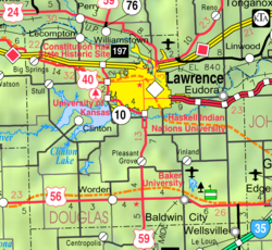
Douglas County is located in the U.S. state of Kansas. As of the 2020 census, the county population was 118,785, making it the fifth-most populous county in Kansas. Its county seat and most populous city is Lawrence.

Eudora is a city in Douglas County, Kansas, United States, along the Kansas and Wakarusa rivers. As of the 2020 census, the population of the city was 6,408.

Lawrence is the county seat of Douglas County, Kansas, United States, and the sixth-largest city in the state. It is in the northeastern sector of the state, astride Interstate 70, between the Kansas and Wakarusa Rivers. As of the 2020 census, the population of the city was 94,934. Lawrence is a college town and the home to both the University of Kansas and Haskell Indian Nations University.

Vinland is an unincorporated community in Douglas County, Kansas, United States. It is located south of Lawrence and north of Baldwin City.

Kansas' 2nd congressional district is a congressional district in the U.S. state of Kansas that covers most of the eastern part of the state, except for the core of the Kansas City Metropolitan Area. The district encompasses less than a quarter of the state. The state capital of Topeka is located within this district. The city of Lawrence, home of one of the state's universities, The University of Kansas, moved from the 2nd to the 1st congressional district in 2022. The district is currently represented by Republican Jake LaTurner.
The Wakarusa War was an armed standoff that took place in the Kansas Territory during November and December 1855. It is often cited by historians as the first instance of violence during the "Bleeding Kansas" conflict between anti-slavery and pro-slavery factions in the region.

Stull is an unincorporated community in Douglas County, Kansas, United States. Founded in 1857, the settlement was initially known as Deer Creek until it was renamed after its only postmaster, Sylvester Stull. As of 2018, only a handful of structures remain in the area.
Clinton is an unincorporated community on a peninsula next to Clinton Lake in Douglas County, Kansas, United States.

Alexander Clark Mitchell was a U.S. Representative from Kansas.

Big Springs is an unincorporated community in northwest Douglas County, Kansas, United States.
Grant Township is a township in Douglas County, Kansas, USA. As of the 2000 census, its population was 442.

Marion Township is a township in Douglas County, Kansas, USA. As of the 2000 census, its population was 836. It was named after the former town of Marion which in turn was named after Francis Marion.

Wakarusa Township is a township in Douglas County, Kansas, USA. As of the 2010 census, its population was 2,318. It was named for the Wakarusa River which flows through Douglas County from Wabaunsee County to the Kansas River near Eudora.

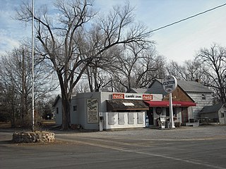
Globe is an unincorporated community in Douglas County, Kansas, United States. It is located along U.S. Highway 56 in Marion Township. To the west of Globe is the Simmons Point Station.
Lone Star is an unincorporated community in Douglas County, Kansas, United States. It is located 7 miles (11 km) southwest of Lawrence.
Pleasant Grove is an unincorporated community in Douglas County, Kansas, United States. It is located four miles south of Lawrence.
Franklin is a ghost town in Douglas County, Kansas, United States. Established as a proslavery stronghold, the town played a key role in the "Bleeding Kansas" conflict that troubled the territory in the 1850s.
Media is a ghost town in Douglas County, Kansas, United States.
Lapeer is a ghost town in Douglas County, Kansas, United States.
Louisiana is a ghost town in Douglas County, Kansas, United States.