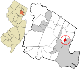
Fairview is an unincorporated community and census-designated place (CDP) located within Middletown Township, in Monmouth County, in the U.S. state of New Jersey. As of the 2010 United States Census, the CDP's population was 3,806.

Silver Ridge is an unincorporated community and census-designated place (CDP) located within Berkeley Township, in Ocean County, in the U.S. state of New Jersey. As of the 2010 United States Census, the CDP's population was 1,133.

Highland Lakes is an unincorporated community and census-designated place (CDP) located within Vernon Township, in Sussex County, in the U.S. state of New Jersey. As of the 2010 United States Census, the CDP's population was 4,933. Highland Lakes has its own Post Office with the ZIP Code 07422.
Columbia is an unincorporated community and census-designated place (CDP) located within Knowlton Township in Warren County, in the U.S. state of New Jersey. While the community has existed for over a century, the CDP was created as part of the 2010 United States Census. As of the 2010 Census, the CDP's population was 229. The area is served as United States Postal Service ZIP Code 07832.

Stewartsville is an unincorporated community and census-designated place (CDP) located within Greenwich Township in Warren County, in the U.S. state of New Jersey, that was created as part of the 2010 United States Census. As of the 2010 Census, the CDP's population was 349.

Port Colden is an unincorporated community and census-designated place (CDP) located within Washington Township, in Warren County, in the U.S. state of New Jersey, that was created as part of the 2010 United States Census. As of the 2010 Census, the CDP's population was 122.

Oxford is an unincorporated community and census-designated place (CDP) located within Oxford Township in Warren County, New Jersey, United States, that was created as part of the 2010 United States Census. As of the 2010 Census, the CDP's population was 1,090.
Florence is an unincorporated community and census-designated place (CDP) located within Florence Township, in Burlington County, in the U.S. state of New Jersey, that was established as part of the 2010 United States Census. As of the 2000 United States Census, the CDP was combined as Florence-Roebling, which had a total population of 8,200. As of the 2010 Census, the Florence-Roebling CDP was split into its components, Roebling and Florence. As of the 2010 Census, the population of the Florence CDP was 4,426.

Anderson is an unincorporated community and census-designated place (CDP) located within Mansfield Township, in Warren County, in the U.S. state of New Jersey, that was created as part of the 2010 United States census. As of the 2020 United States census, the CDP's population was 306, a decrease of 36 (-10.5%) from the 342 enumerated at the 2010 census.

Brainards is an unincorporated community and census-designated place (CDP) located within Harmony Township, in Warren County, in the U.S. state of New Jersey, that was created as part of the 2010 United States Census. As of the 2010 United States Census, the CDP's population was 202. It was formerly known as Martin's Creek.
Bridgeville is an unincorporated community and census-designated place (CDP) located within White Township, in Warren County, in the U.S. state of New Jersey, that was created as part of the 2010 United States Census. As of the 2010 Census, the CDP's population was 106.
Broadway is an unincorporated community and census-designated place (CDP) located within Franklin Township, in Warren County, in the U.S. state of New Jersey, that was created as part of the 2010 United States Census. As of the 2010 Census, the CDP's population was 244.
Upper Stewartsville is an unincorporated community and census-designated place (CDP) located within Greenwich Township in Warren County, in the U.S. state of New Jersey, that was defined as part of the 2010 United States Census. As of the 2010 Census, the CDP's population was 212.
Harmony is an unincorporated community and census-designated place (CDP) located within Harmony Township in Warren County, in the U.S. state of New Jersey, that was defined as part of the 2010 United States Census. As of the 2010 Census, the CDP's population was 441.
Hutchinson is an unincorporated community and census-designated place (CDP) located within Harmony Township in Warren County, in the U.S. state of New Jersey, that was defined as part of the 2010 United States Census. As of the 2010 Census, the CDP's population was 135.

Hope is an unincorporated community and census-designated place (CDP) located within Hope Township in Warren County, in the U.S. state of New Jersey, that was defined as part of the 2010 United States Census. As of the 2010 Census, the CDP's population was 195.
Mount Hermon is an unincorporated community and census-designated place (CDP) located within Hope Township in Warren County, in the U.S. state of New Jersey, that was defined as part of the 2010 United States Census. As of the 2010 Census, the CDP's population was 141.
Silver Lake is an unincorporated community and census-designated place (CDP) located within Hope Township in Warren County, in the U.S. state of New Jersey, that was defined as part of the 2010 United States Census. As of the 2010 Census, the CDP's population was 368.
Mountain Lake is an unincorporated community and census-designated place (CDP) located within Liberty Township in Warren County, in the U.S. state of New Jersey, that was created as part of the 2010 United States Census. As of the 2020 United States census, the CDP's population was 494 a decrease of 81 (−14.1%) from the 575 recorded at the 2010 census.
Upper Pohatcong is an unincorporated community and census-designated place (CDP) located within Pohatcong Township in Warren County, in the U.S. state of New Jersey, that was defined as part of the 2010 United States Census. As of the 2010 Census, the CDP's population was 1,781.