Brookdale, New Jersey

Last updated

Brookdale, New Jersey
Essex County New Jersey incorporated and unincorporated areas Brookdale highlighted.svg
Location in Essex County and the state of New Jersey.
Location map of Essex County, New Jersey.svg
Red pog.svg
Brookdale
Location in Essex County
USA New Jersey relief location map.svg
Red pog.svg
Brookdale
Location in New Jersey
Usa edcp relief location map.png
Red pog.svg
Brookdale
Location in the United States
Coordinates: 40°50′06″N74°10′47″W / 40.834945°N 74.179777°W / 40.834945; -74.179777
Country Flag of the United States.svg  United States
State Flag of New Jersey.svg  New Jersey
County Essex
Township Bloomfield
Area
[1]
  Total1.61 sq mi (4.17 km2)
  Land1.60 sq mi (4.15 km2)
  Water0.01 sq mi (0.02 km2)  0.26%
Elevation
[2]
177 ft (54 m)
Population
 (2020) [3]
  Total9,854
  Density6,147.22/sq mi (2,373.95/km2)
Time zone UTC−05:00 (Eastern (EST))
  Summer (DST) UTC−04:00 (EDT)
ZIP Code
07003 - Bloomfield [4]
FIPS code 34-08110 [5] [6]
GNIS feature ID02583975 [7]

Brookdale is an unincorporated community and census-designated place (CDP) [8] located in Bloomfield Township, located within Essex County, in the U.S. state of New Jersey. [9] It is generally considered to be the part of Bloomfield north of Bay Avenue.[ citation needed ] As of the 2020 United States census, the CDP's total population was 9,854, [3] an increase of 615 (+6.7%) from the 9,239 counted in the 2010 census. [10]

Contents

History

The original English name of Brookdale was Stone House Plains. "Stone House" referred to a rock formation known as the stone house or great rock, supposedly once suitable as a shelter, just north of the present-day intersection of Bellevue Avenue and Newell Drive. [11] The rock was still present in 1802 but was removed not long afterward. [12] "Plains" referred to the plains of the segment of the Yantecaw River which passes through the area. [13]

Early farmhouse in Brookdale/Stone House Plains Farmhouse, Stone House Plains.jpg
Early farmhouse in Brookdale/Stone House Plains

Within a decade or so of the turn of the 18th century, settlers, possibly including Abraham Van Giesen, had begun to populate the area along Bellevue Avenue. [12] By about 1750, two brothers, Garrabrant and Teunis Garrabrant, born in 1723 and 1726, respectively, to Cornelius and Jannetje (Pier) Gerbrandsen in Bergen (now Jersey City), owned sizeable tracts in the vicinity of Brookdale Park, Bellevue Avenue, and Broad Street. [14] Circa 1730, Alexander Cockefair, born about 1696 in Bushwick, purchased a "plantation" roughly bounded by the Yantacaw Brook, and modern-day Broad Street and Watchung Avenue. [15] The Sigler and Coeyman families also had very early farms in Stone House Plains. [16] Descendants of these families operated farms, mills, and other businesses in the area for over two centuries. [17]

Dutch was the primary language for many residents through the 18th century. In 1795, the Dutch Reformed Church of Stone House Plains (now Brookdale Reformed Church) was formed, creating a spiritual and social focal point for the community. The original church edifice was built in 1802; it burned and was rebuilt about 1857. [18] The Morris family, which operated mills just south of Brookdale, made a mill pond on the Yantacaw Brook. [19] In the mid-1800s, residents established the first school. In 1873, on the eve of US mail delivery service, the community voted to change the name to Brookdale. [20]

After World War I, much of the farmland was developed into residential housing. The Clark Thread Company bought the Morris Pond (now Clark's Pond) and built an adjoining thread-coloring factory, later occupied by the Scientific Glass Company. [21] Portions of the Cockefair farm were converted into a golf course and a junior high school (now Bloomfield Middle School). Essex County acquired and built Brookdale Park. In 1968, the petrochemical engineering firm Lummus Company set up in northern Brookdale. [22]

Geography

According to the United States Census Bureau, the CDP had a total area of 1.607 square miles (4.163 km2), including 1.603 square miles (4.152 km2) of land and 0.004 square miles (0.011 km2) of water (0.26%). [23] [24]

Demographics

Historical population
CensusPop.Note
2010 9,239
2020 9,8546.7%
Population sources:
2010 [10] 2020 [3]

2010 census

The 2010 United States census counted 9,239 people, 3,445 households, and 2,580 families in the CDP. The population density was 5,763.0 per square mile (2,225.1/km2). There were 3,583 housing units at an average density of 2,234.9 per square mile (862.9/km2). The racial makeup was 76.46% (7,064) White, 4.96% (458) Black or African American, 0.11% (10) Native American, 12.25% (1,132) Asian, 0.02% (2) Pacific Islander, 3.00% (277) from other races, and 3.20% (296) from two or more races. Hispanic or Latino of any race were 11.74% (1,085) of the population. [10]

Of the 3,445 households, 32.3% had children under the age of 18; 62.1% were married couples living together; 10.0% had a female householder with no husband present and 25.1% were non-families. Of all households, 20.1% were made up of individuals and 9.2% had someone living alone who was 65 years of age or older. The average household size was 2.68 and the average family size was 3.13. [10]

21.9% of the population were under the age of 18, 6.0% from 18 to 24, 27.4% from 25 to 44, 29.5% from 45 to 64, and 15.2% who were 65 years of age or older. The median age was 41.6 years. For every 100 females, the population had 89.2 males. For every 100 females ages 18 and older there were 87.0 males. [10]

Related Research Articles

<span class="mw-page-title-main">Golden Triangle, New Jersey</span> Populated place in Camden County, New Jersey, US

Golden Triangle is an unincorporated community and census-designated place (CDP) located within Cherry Hill, in Camden County, in the U.S. state of New Jersey. As of the 2010 United States Census, the CDP's population was 4,145.

<span class="mw-page-title-main">Bloomfield, New Jersey</span> Township in Essex County, New Jersey, United States

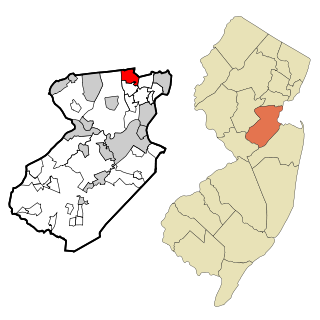
Bloomfield is a township in Essex County, in the U.S. state of New Jersey. As of the 2020 United States census, the township's population was 53,105, an increase of 5,790 (+12.2%) from the 2010 census count of 47,315, which in turn reflected a decline of 368 (-0.8%) from the 47,683 counted in the 2000 census. It surrounds the Bloomfield Green Historic District.

<span class="mw-page-title-main">Colonia, New Jersey</span> Place in Middlesex County, New Jersey, United States

Colonia is an unincorporated community and census-designated place (CDP) located within Woodbridge Township, in Middlesex County, in the U.S. state of New Jersey. As of the 2010 United States Census, the CDP's population was 17,795.

<span class="mw-page-title-main">Madison Park, New Jersey</span> Populated place in Middlesex County, New Jersey, US

Madison Park is an unincorporated community and census-designated place (CDP) located within Old Bridge Township, in Middlesex County, in the U.S. state of New Jersey. As of the 2010 United States Census, the CDP's population was 7,144. The name "Madison Park" reflects Old Bridge's original name of "Madison Township" which it had when it was formed on March 2, 1869 from portions of South Amboy Township, until November 5, 1975, when voters approved a referendum changing the township's name to Old Bridge Township.

<span class="mw-page-title-main">Lincroft, New Jersey</span> Populated place in Monmouth County, New Jersey, US

Lincroft is an unincorporated community and census-designated place (CDP) within Middletown Township, in Monmouth County, in the U.S. state of New Jersey. As of the 2020 United States census, the CDP had a population of 7,060, reflecting a 15.1% increase from the 6,135 residents enumerated at the 2010 U.S. Census, in turn a decline of 120 residents (-1.9%) from the 6,255 counted in the 2000 U.S. Census.

<span class="mw-page-title-main">Dover Beaches North, New Jersey</span> Populated place in Ocean County, New Jersey, US

Dover Beaches North is an unincorporated community and census-designated place (CDP) located within Toms River, in Ocean County, in the U.S. state of New Jersey. As of the 2010 United States Census, the CDP's population was 1,239. The CDP includes the communities of Ocean Beaches 1, 2 and 3, Chadwick Beach, Chadwick Island, Seacrest Beach, Monterey Beach, Silver Beach, Normandy Shores and half of Normandy Beach. Dover Beaches North is situated on the Barnegat Peninsula, a long, narrow barrier peninsula that separates Barnegat Bay from the Atlantic Ocean.

<span class="mw-page-title-main">Dover Beaches South, New Jersey</span> Populated place in Ocean County, New Jersey, US

Dover Beaches South, more commonly known as Ortley Beach, is an unincorporated community and census-designated place (CDP) located within Toms River, in Ocean County, in the U.S. state of New Jersey. As of the 2010 United States Census, the CDP's population was 1,209. Dover Beaches South is situated on the Barnegat Peninsula, a long, narrow barrier peninsula that separates Barnegat Bay from the Atlantic Ocean.

<span class="mw-page-title-main">Folsom, Pennsylvania</span> Census-designated place in Pennsylvania, United States

Folsom is a census-designated place (CDP) in Delaware County, Pennsylvania, United States. It is part of Ridley Township. The population was 8,323 at the 2010 census.

<span class="mw-page-title-main">Upper Montclair, New Jersey</span> Place in Essex County, New Jersey, United States

Upper Montclair is a census-designated place (CDP), unincorporated community and neighborhood within Montclair in Essex County, in the U.S. state of New Jersey. As of the 2010 United States Census, the population for the CDP was 11,565. The area is served as United States Postal Service ZIP Code 07043. It is often misperceived, even by Montclair residents, to be a separate municipality from Montclair, perhaps aided by this postal designation.

<span class="mw-page-title-main">Middlebush, New Jersey</span> Populated place in Somerset County, New Jersey, US

Middlebush is an unincorporated community and census-designated place (CDP) located in Franklin Township, in Somerset County, in the U.S. state of New Jersey. As of the 2010 United States Census, the CDP's population was 2,326. It is perhaps most distinguished as being the host section for Franklin Township's municipal complex.

<span class="mw-page-title-main">Kenvil, New Jersey</span> Populated place in Morris County, New Jersey, US

Kenvil is an unincorporated community and census-designated place (CDP) located within Roxbury Township, in Morris County, in the U.S. state of New Jersey, that had been part of the Succasunna-Kenvil CDP as part of the 2000 United States Census, at which time the population of the combined was 12,569. For the 2010 census, the area was split into two CDPs, Succasunna and Kenvil.

<span class="mw-page-title-main">Singac, New Jersey</span> Populated place in Passaic County, New Jersey, US

Singac is an unincorporated community and census-designated place (CDP) located within Little Falls, in Passaic County, in the U.S. state of New Jersey. As of the 2010 United States Census, the CDP's population was 3,618.

<span class="mw-page-title-main">Pleasant Plains, New Jersey</span> Populated place in Somerset County, New Jersey, US

Pleasant Plains is an unincorporated community and census-designated place (CDP) located in Franklin Township, in Somerset County, in the U.S. state of New Jersey. As of the 2010 United States Census, the CDP's population was 922. Having no distinct boundaries, a large area in the center of Franklin Township centered on the intersections of South Middlebush Road with Claremont and Suydam Roads is generally considered Pleasant Plains.

<span class="mw-page-title-main">Roebling, New Jersey</span> Populated place in Burlington County, New Jersey, US

Roebling is an unincorporated community and census-designated place (CDP) located within Florence Township, in Burlington County, in the U.S. state of New Jersey, that was established as part of the 2010 United States census. As of the 2000 United States census, the CDP was combined as Florence-Roebling, which had a total population of 8,200. As of the 2010 Census, the Florence-Roebling CDP was split into its components, Florence and Roebling. As of the 2010 Census, the population of the Florence CDP was 4,426.

<span class="mw-page-title-main">Mercerville, New Jersey</span> Populated place in Mercer County, New Jersey, US

Mercerville is an unincorporated community and census-designated place (CDP) located within Hamilton Township, in Mercer County, in the U.S. state of New Jersey. As of the 2010 United States Census, the CDP's population was 13,230. Until after the 2000 census, the area was part of the Mercerville-Hamilton Square CDP. For the 2010 Census it was split into two CDPs, Mercerville and Hamilton Square.

Vienna is an unincorporated community and census-designated place (CDP) located within Independence Township in Warren County, in the U.S. state of New Jersey, that was created as part of the 2010 United States Census. As of the 2010 Census, the CDP's population was 981.

<span class="mw-page-title-main">Marksboro, New Jersey</span> Census-designated place in Warren County, New Jersey, United States

Marksboro is an unincorporated community and census-designated place (CDP) located within Frelinghuysen Township in Warren County, in the U.S. state of New Jersey, that was created as part of the 2010 United States Census, though settlement and naming of the community date back to before 1760. As of the 2010 Census, the CDP's population was 82.

<span class="mw-page-title-main">Barclay, New Jersey</span> Populated place in Camden County, New Jersey, US

Barclay Farm is an unincorporated community and census-designated place (CDP) located within Cherry Hill, in Camden County, in the U.S. state of New Jersey, that had been part of the Barclay-Kingston CDP until 2000, which was split to form the CDPs of Barclay and Kingston Estates as of the 2010 Census. Until the 2000 census, Barclay was included as part of the Barclay-Kingston CDP. As of the 2010 United States Census, the CDP's population was 4,428.

<span class="mw-page-title-main">Florence (CDP), New Jersey</span> Populated place in Burlington County, New Jersey, US

Florence is an unincorporated community and census-designated place (CDP) located within Florence Township, in Burlington County, in the U.S. state of New Jersey, that was established as part of the 2010 United States Census. As of the 2000 United States Census, the CDP was combined as Florence-Roebling, which had a total population of 8,200. As of the 2010 Census, the Florence-Roebling CDP was split into its components, Roebling and Florence. As of the 2010 Census, the population of the Florence CDP was 4,426.

<span class="mw-page-title-main">Silver Lake, Essex County, New Jersey</span> Populated place in Essex County, New Jersey, US

Silver Lake is an unincorporated community and census-designated place (CDP) in Essex County, in the U.S. state of New Jersey, that is split between Belleville and Bloomfield. As of the 2010 United States Census, the CDP's total population was 4,243.

References

  1. "ArcGIS REST Services Directory". United States Census Bureau. Retrieved October 11, 2022.
  2. U.S. Geological Survey Geographic Names Information System: Brookdale Census Designated Place, Geographic Names Information System. Accessed November 6, 2012.
  3. 1 2 3 QuickFacts Brookdale CDP, New Jersey, United States Census Bureau. Accessed June 17, 2023.
  4. Look Up a ZIP Code for Brookdale, NJ, United States Postal Service. Accessed November 6, 2012.
  5. U.S. Census website, United States Census Bureau. Accessed September 4, 2014.
  6. Geographic Codes Lookup for New Jersey, Missouri Census Data Center. Accessed June 9, 2023.
  7. US Board on Geographic Names, United States Geological Survey. Accessed September 4, 2014.
  8. State of New Jersey Census Designated Places - BVP20 - Data as of January 1, 2020, United States Census Bureau. Accessed December 1, 2022.
  9. New Jersey: 2010 - Population and Housing Unit Counts - 2010 Census of Population and Housing (CPH-2-32), United States Census Bureau, August 2012, p. III-3. Accessed November 6, 2012."
  10. 1 2 3 4 5 DP-1 - Profile of General Population and Housing Characteristics: 2010 Demographic Profile Data for Brookdale CDP, New Jersey Archived 2020-02-12 at archive.today , United States Census Bureau. Accessed November 6, 2012.
  11. Lee, Francis Bazley. Genealogical and Memorial History of the State of New Jersey, p. 175. Lewis Historical Publishing Company, 1910. Accessed June 14, 2016.
  12. 1 2 Folsom, Joseph F. Bloomfield, old and new: an historical symposium, pp. 167-168. Local resident Lewis Cockefair, born 1826, was used extensively as a source, and he evidently did not have first-hand knowledge of it.
  13. Google Maps, accessed Jun 13, 2016.
  14. Folsom, Joseph F., Bloomfield, old and new: an historical symposium, p 177-178.
  15. Folsom, Joseph F., Bloomfield, old and new: an historical symposium, p 171-174.
  16. Folsom, Joseph F. Bloomfield, old and new: an historical symposium, p. 177-179.
  17. Folsom, Joseph F. Bloomfield, old and new: an historical symposium, p. 165-166.
  18. Folsom, Joseph F. Bloomfield, old and new: an historical symposium, p. 122.
  19. Sidney, J. C. Map of Essex County, New Jersey: with the names of property holders (Newark N.J.: H.A. Belding, 1850), Library of Congress. Accessed June 14, 2016.
  20. Folsom, Joseph F. Bloomfield, old and new: an historical symposium, p. 162.
  21. "The New Town Crier" newsletter, Historical Society of Bloomfield, May 2013, p. 2.
  22. "A Brief History of Bloomfield" Archived 2018-04-05 at the Wayback Machine , Township of Bloomfield, New Jersey, December 8, 2014. Accessed June 14, 2016.
  23. Gazetteer of New Jersey Places, United States Census Bureau. Accessed July 21, 2016.
  24. US Gazetteer files: 2010, 2000, and 1990, United States Census Bureau. Accessed September 4, 2014.