
Baramulla district or Varmul is one of the 20 districts in the Indian-administered union territory of Jammu and Kashmir in the disputed Kashmir region. Baramulla town is the administrative headquarters of this district. The district covered an area of 4,588 km2 (1,771 sq mi) in 2001, but it was reduced to 4,243 km2 (1,638 sq mi) at the time of 2011 census. In 2016, the district administration said that the area was 4,190 km2 (1,620 sq mi). Muslims constitute about 98% of the population.

The Jammu–Baramulla line is a railway track being laid to connect the Kashmir Valley in the Indian union territory of Jammu and Kashmir with Jammu railway station and thence to the rest of the country. The 338 km railway track will start from Jammu and end at Baramulla. It comes under the jurisdiction of the Firozpur railway division of Indian Railways' Northern zone. Part of this railway route from Udhampur to Baramulla is known as Udhampur-Srinagar-Baramula Rail Link (USBRL). The 359 m (1,178 ft) tall Chenab Bridge lies on this line, which is the tallest railway bridge in the world. The total project cost in 2022 was INR28,000 crore.
Kupwara is a city, District headquarter and a municipal council in Kupwara district in the Indian union territory of Jammu and Kashmir.
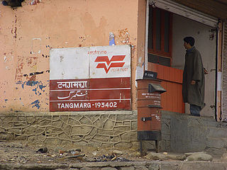
Tangmarg is a town and tehsil in Baramulla district in Indian union territory of Jammu and Kashmir. In 2014, Tangmarg was granted a sub division and trifurcated into three Tehsils, with Sub Divisional Magistrate SDM Office located at Tangmarg. The Tangmarg town is central to more than 100 villages in the vicinity. Tangmarg is gateway of gulmarg which is just 13kms away, also drung waterfall is 3kms away which makes tangmarg most crowded place in the evening due to clean & fresh environment.

Jammu and Kashmir is home to several valleys such as the Kashmir Valley, Chenab Valley, Sindh Valley and Lidder Valley. Some major tourist attractions in Jammu and Kashmir are Srinagar, with its renowned Dal Lake and Mughal Gardens, Gulmarg, Pahalgam, Bhaderwah, Patnitop and Jammu. Every year, thousands of Hindu pilgrims visit holy shrines of Vaishno Devi and Amarnath which has had a significant impact on the state's economy.
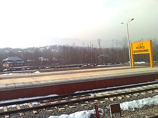
Qazigund railway station lies on Northern Railway network zone of Indian Railways. It is located in Qazigund Jammu and Kashmir, India. It is the main transport hub for the people of Qazigund.
Baramulla Railway Station is situated in outskirts of baramulla town nearly about 5 km from main town. Transport facility is available in working hours from main town baramulla to railway station and vice versa. It is the first station of 130 km long railway line which connects Kashmir Valley with Banihal.

Shri Mata Vaishno Devi Katra railway station is a railway station on the Jammu Udhampur Srinagar Baramulla Railway Link in the Indian Union Territory of Jammu and Kashmir. It mainly serves for the town of Katra where the major hindu divine temple Shri Mata Vaishno Devi is situated which is visited by millions of travellers per month with the help of this station and its frequent special trains connectivity from all over India. The station belongs to the Firozpur division of Northern Railway zone in Jammu and Kashmir.
Hanjiwera is a notified area and village in Singhpora, Pattan, Baramulla district in Indian union territory of Jammu and Kashmir. It is located 31 km (19 mi) to the east from the district headquarters in Baramulla and 23 km (14 mi) from union territory capital, Srinagar.
Hamray or Hamre is a village in the Pattan tehsil of Baramulla district in Jammu and Kashmir, India, located 7 km away from Pattan town along the Srinagar- Baramulla highway.
Pattan, is a sub-district town and a municipal community in Baramulla district within the Indian Union Territory of Jammu and Kashmir.
Bijbiara Railway Station is a railway station on the Northern Railway network in Anantnag, Jammu and Kashmir. It is the twelfth station on the railway line about 93 km (58 mi) from Baramulla railway station. It is 3 km (1.9 mi) away from the main town.
Budgam Railway Station is a station on Northern Railway Network of Indian Railways. This station is the headquarter of Jammu–Baramulla line network. It is located in Ompora, a town in Budgam district nearly 2.5 km (1.6 mi) from main town Budgam.
Pampur railway station is the railway station on the Jammu–Baramulla line in the Indian union territory of Jammu and Kashmir. It is one of the four stations in Pulwama district, the others being Awantipora railway station, Kakapora railway station and Panchgam railway station respectively.
Mazhom Railway Station, also known as Mazhama railway station, lies on Northern Railway Network Zone of Indian Railways. It is situated 20 kilometres (12 mi) west of Srinagar on Gulmarg Road. It is the major railway stations in Budgam district. The station connects Magam town with rest of the parts of state. The station comes under Firozpur division of Indian railways and has an average elevation of 1,581 meters (5,187 ft) above mean sea level.

Hathlangoo previously known as Hashmatpora is a village in the Sopore tehsil of Baramulla district, in the Indian union territory of Jammu and Kashmir. It is located 8 km (5.0 mi) away from sub-district headquarter Sopore and 22 km (14 mi) away from district headquarters Baramulla. It is one of the largest villages in Zaingair. The Hathlangoo village has Janwara Village in the South, Magraypora in the North, Botingoo in the Northwest, Malmapanpora in the West and Wular Lake in the East.
Waripora Bangil is a village located in the town of Kunzer in the Baramulla district of the Indian-administered union territory of Jammu and Kashmir. It is situated 40 kilometres (25 mi) east of the district headquarters of Baramulla and 20 kilometres (12 mi) west of the capital city of Srinagar.
Teetwal is a small border-village in Jammu and Kashmir, India. It is situated on the banks of the Kishanganga River in Kupwara district, 82 km (51 mi) from the district headquarters of Kupwara and close to the Line of Control with Pakistani-administered Kashmir. Teetwal is connected to the rest of India via Tangdhar.
Wavoora is a village in Kupwara district of the Indian union territory of Jammu and Kashmir. The town is located 13 km (8.1 mi) from district headquarters Kupwara.
Drugmulla is a village and tehsil headquarter in Kupwara district of the Indian union territory of Jammu and Kashmir. It is located 5 kilometres from the district headquarters Kupwara.
